File:Floor Plan ^ Sections - Thomas Murphy Homestead, Barn, Approximately 125 feet north of House, Kelly, Teton County, WY - LOC - hhh.wy0580.sheet.00002a.tif
Jump to navigation
Jump to search

Size of this JPG preview of this TIF file: 800 × 528 pixels. Other resolutions: 320 × 211 pixels | 640 × 423 pixels | 1,024 × 676 pixels | 1,280 × 845 pixels | 2,560 × 1,690 pixels | 14,590 × 9,632 pixels.
Original file (14,590 × 9,632 pixels, file size: 16.77 MB, MIME type: image/tiff)
Captions
Captions
Add a one-line explanation of what this file represents

Summary
[edit]| Warning | The original file is very high-resolution. It might not load properly or could cause your browser to freeze when opened at full size. |
|---|
| Description |
English: Floor Plan & Sections - Thomas Murphy Homestead, Barn, Approximately 125 feet north of House, Kelly, Teton County, Wyoming |
||
| Source |
|
||
| Author | Agutter, Jim | ||
| Permission (Reusing this file) |
Historic American Buildings Survey/Historic American Engineering Record/Historic American Landscape Survey Collection Rights and Restrictions Information |

Licensing
[edit]
|
This file comes from the Historic American Buildings Survey (HABS), Historic American Engineering Record (HAER) or Historic American Landscapes Survey (HALS). These are programs of the National Park Service established for the purpose of documenting historic places. Records consist of measured drawings, archival photographs, and written reports.
This tag does not indicate the copyright status of the attached work. A normal copyright tag is still required. See Commons:Licensing. |
This work is in the public domain in the United States because it is a work prepared by an officer or employee of the United States Government as part of that person’s official duties under the terms of Title 17, Chapter 1, Section 105 of the US Code.
Note: This only applies to original works of the Federal Government and not to the work of any individual U.S. state, territory, commonwealth, county, municipality, or any other subdivision. This template also does not apply to postage stamp designs published by the United States Postal Service since 1978. (See § 313.6(C)(1) of Compendium of U.S. Copyright Office Practices). It also does not apply to certain US coins; see The US Mint Terms of Use.
|
 | |
| This file has been identified as being free of known restrictions under copyright law, including all related and neighboring rights. | ||
File history
Click on a date/time to view the file as it appeared at that time.
| Date/Time | Thumbnail | Dimensions | User | Comment | |
|---|---|---|---|---|---|
| current | 18:02, 1 April 2013 |  | 14,590 × 9,632 (16.77 MB) | Denniss (talk | contribs) | uncompressed |
| 21:44, 13 January 2012 | 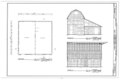 | 14,590 × 9,632 (1.64 MB) | BotMultichillT (talk | contribs) | {{User:Multichill/HABS |dc.rights=Unrestricted online access |dc.identifier=http://hdl.loc.gov/loc.pnp/hhh.wy0580/sheet.00002a |dc.type=still image |state=WY |county=Teton County |tifurl=http://lcweb2.loc.gov/pnp/habshaer/wy/wy0500/wy0580/sheet/00002a.tif |
You cannot overwrite this file.
File usage on Commons
The following 2 pages use this file:
- File:Floor Plan ^ Sections - Thomas Murphy Homestead, Barn, Approximately 125 feet north of House, Kelly, Teton County, WY - LOC - hhh.wy0580.sheet.00002a.jpg
- File:Floor Plan ^ Sections - Thomas Murphy Homestead, Barn, Approximately 125 feet north of House, Kelly, Teton County, WY - LOC - hhh.wy0580.sheet.00002a .tif (file redirect)