File:Flooding in the Philippines (MODIS).jpg

Original file (1,223 × 738 pixels, file size: 152 KB, MIME type: image/jpeg)
Captions
Captions
Summary
[edit].jpg&action=edit§ion=1)
| Description |
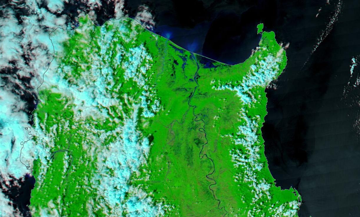
English: Typhoon Nesat made landfall over Calayan Island, Philippines, on October 16, 2022. Although the storm’s winds were not catastrophic, extreme rains brought heavy flooding to northern Philippines, especially the large island of Luzon and the small Calayan Island, which sits about 190 miles (306 km) north of Luzon.
Today’s Image of the Day compares two false-color images of the northeast tip of Luzon Island after the passage of Typhoon Nesat. Both images were acquired by the Moderate Resolution Imaging Spectroradiometer (MODIS) on board NASA’s Aqua satellite. The upper image was acquired on October 17, as skies were beginning to clear. Much of the northern coast was completely under water, and flood water (which appears blue) is present more than 20 miles inland. The Cagayan River had overflowed its banks, creating additional flooding near the river’s course. The lower image was acquired on September 15, a month before Nesat’s passage, showing a much different scene. The comparison between the two dates is stark. According to Agroinsurance, on October 19 damage to agriculture in the Philippines from Nesat was estimated at 366,058,240 Philippine pesos. This is equivalent to about $6,214,383 US dollars. It is also estimated that 14,578 farmers had been affected, with over 19,000 hectares of crops damaged. Cagayan Valley suffered the greatest agricultural loss. |
||
| Date | Taken on 17 October 2022 | ||
| Source |
Flooding in the Philippines (direct link)
|
||
| Author | MODIS Land Rapid Response Team, NASA GSFC |
| This media is a product of the Aqua mission Credit and attribution belongs to the mission team, if not already specified in the "author" row |
Licensing
[edit].jpg&action=edit§ion=2)
| This file is in the public domain in the United States because it was solely created by NASA. NASA copyright policy states that "NASA material is not protected by copyright unless noted". (See Template:PD-USGov, NASA copyright policy page or JPL Image Use Policy.) | ||
 |
Warnings:
|
File history
Click on a date/time to view the file as it appeared at that time.
| Date/Time | Thumbnail | Dimensions | User | Comment | |
|---|---|---|---|---|---|
| current | 22:06, 8 September 2023 | | 1,223 × 738 (152 KB) | OptimusPrimeBot (talk | contribs) | #Spacemedia - Upload of http://modis.gsfc.nasa.gov/gallery/images/image10212022_250m.jpg via Commons:Spacemedia |
You cannot overwrite this file.
File usage on Commons
There are no pages that use this file.
.jpg&oldid=909384454)