File:Flooding in California (MODIS 2023-01-05).jpg

Original file (962 × 616 pixels, file size: 477 KB, MIME type: image/jpeg)
Captions
Captions
Summary
[edit].jpg&action=edit§ion=1)
| Description |
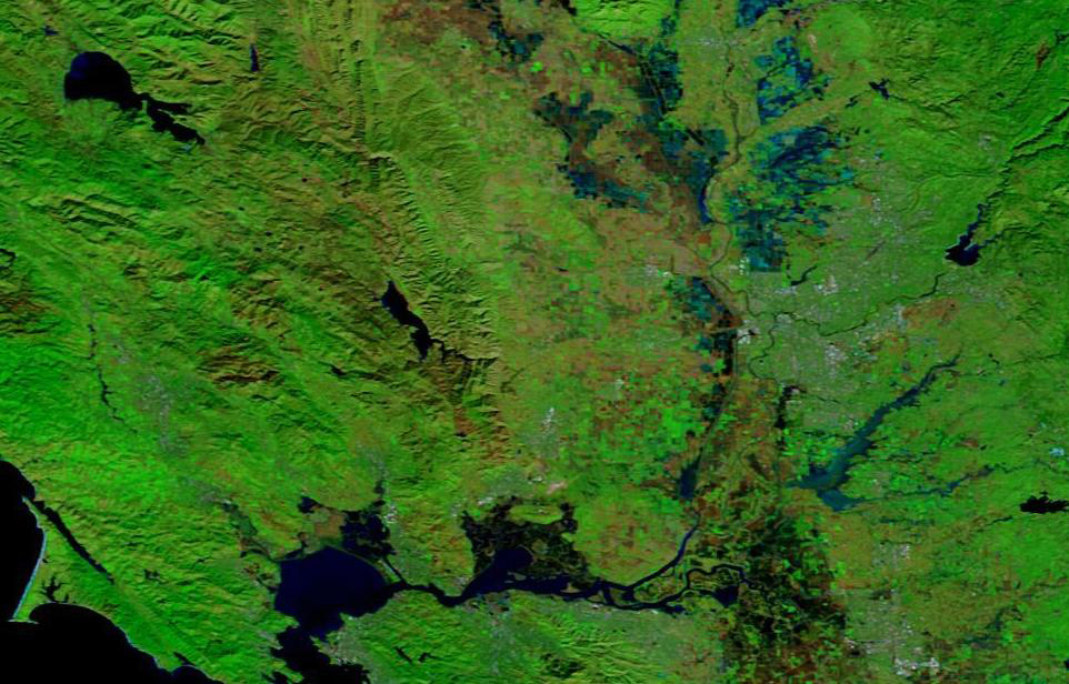
English: Heavy rain hit parts of central and northern California on New Year’s Eve 2022, flooding communities near San Francisco and Sacramento. Water breached levees along the Cosumnes River near Wilton, California, flooding numerous roads including Highway 99—a major thoroughfare in the Central Valley. Wilton and other nearby farming communities were issued evacuation orders.
The Bay Area National Weather Service measured 5.5 inches (14 centimeters) of rain in downtown San Francisco on December 31, 2022, the second wettest day in more than 170 years of record-keeping. This daily total is about half of the city’s expected rainfall for the entire month of December. Toward the northeast in Sacramento County, some areas recorded up to 4 inches (10 centimeters) of rain within 24 hours, according to the National Weather Service. The flooding that ensued is visible in the false-color image (top) acquired on January 1, 2023, by the Moderate Resolution Imaging Spectroradiometer (MODIS) on NASA’s Terra satellite. Water appears light to dark blue. Vegetation is green and bare land is brown. For comparison, the Terra MODIS image acquired on November 19, 2022 (lower image) shows the same area prior to the intense rainfall. Near Wilton, levees of the Cosumnes River have been breached. The Sacramento County Office of Emergency Services urged residents of Wilton, California, to evacuate on December 31, 2022, but changed the order a few hours later to shelter-in-place due to treacherous road conditions in the area. As flooding moved southwest along the Cosumnes River on January 1, residents of Point Pleasant were ordered to leave their homes and move livestock. Emergency personnel rescued people from roofs of cars, and several people in Wilton were stranded in their homes. Hundreds of people in Sacramento County were still without power as of the morning of January 3, 2023. Crews of the Cosumnes River Levee District scrambled to fix the levee breaches as another major winter storm approached North Central California. On January 4, California Governor Gavin Newsome declared a state of emergency just ahead of the arrival of howling winds and drenching rain later that day. Dozens of flights have been cancelled at the San Francisco International Airport, while some schools in that city cancelled schools for January 5, based on the expectation of extremely difficult conditions. The Director of the California Governor’s Office of Emergency Services was quoted as describing the current storm, which began on the afternoon of January 4 and is expected to last at least through January 5 with these words: “We anticipate that this may be one of the most challenging and impactful series of storms to touch down in California in the last five years.” |
||
| Date | 5 January 2023 (upload date) | ||
| Source |
Flooding in California (direct link)
|
||
| Author | MODIS Land Rapid Response Team, NASA GSFC |
| This media is a product of the Terra mission Credit and attribution belongs to the mission team, if not already specified in the "author" row |
Licensing
[edit].jpg&action=edit§ion=2)
| This file is in the public domain in the United States because it was solely created by NASA. NASA copyright policy states that "NASA material is not protected by copyright unless noted". (See Template:PD-USGov, NASA copyright policy page or JPL Image Use Policy.) | ||
 |
Warnings:
|
File history
Click on a date/time to view the file as it appeared at that time.
| Date/Time | Thumbnail | Dimensions | User | Comment | |
|---|---|---|---|---|---|
| current | 18:18, 27 December 2023 | | 962 × 616 (477 KB) | OptimusPrimeBot (talk | contribs) | #Spacemedia - Upload of http://modis.gsfc.nasa.gov/gallery/images/image01052023_250m.jpg via Commons:Spacemedia |
You cannot overwrite this file.
File usage on Commons
There are no pages that use this file.
.jpg&oldid=835720841)