File:Flooded areas, Cumberland River, Clear Fork, and Brier Creek, vicinity of Williamsburg, Ky. LOC gm69003387.jpg
Jump to navigation
Jump to search

Size of this preview: 800 × 485 pixels. Other resolutions: 320 × 194 pixels | 640 × 388 pixels | 1,024 × 621 pixels | 1,280 × 776 pixels | 2,560 × 1,553 pixels | 8,500 × 5,156 pixels.
Original file (8,500 × 5,156 pixels, file size: 4.61 MB, MIME type: image/jpeg)
Captions
Captions
Add a one-line explanation of what this file represents
Summary
[edit]| Description |
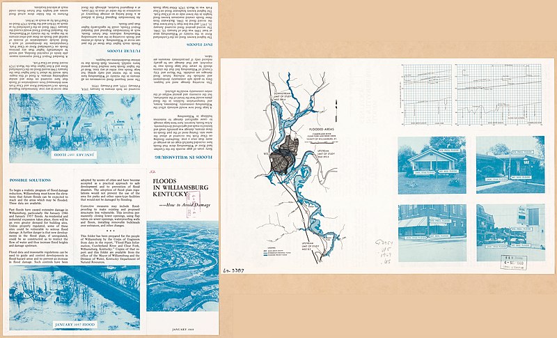
English: Scale ca. 1:62,000. Folded title: Floods in Williamsburg, Kentucky--How to avoid damage. Includes 2 "Flood elevations" charts. Text and illus. on verso. Available also through the Library of Congress Web site as a raster image. AACR2: 110; 650/1; 650/2 |
||
| Title | Flooded areas, Cumberland River, Clear Fork, and Brier Creek, vicinity of Williamsburg, Ky. | ||
| Shelf ID | G3954.W5 1969 .U5 | ||
| Date | |||
| Source | https://www.loc.gov/item/gm69003387/ | ||
| Author | United States. Army. Corps Of Engineers | ||
| Permission (Reusing this file) |
|
||
| Other versions |
|
||
| Location | Williamsburg. · Tennessee · Cumberland River · Williamsburg · Kentucky · United States · Clear Fork · Cumberland River. · Brier Creek. · Brier Creek · Clear Fork. | ||
| Part of | American Memory · General Maps · Catalog · Geography And Map Division | ||
| Subject | Clear Fork · Floods · Williamsburg · Kentucky · United States · Maps · Brier Creek · Cumberland River (Ky. And Tenn.) · Cumberland River |

Licensing
[edit]
| This work is from the Library of Congress. According to the library, there are no known copyright restrictions on the use of this work. |  |
File history
Click on a date/time to view the file as it appeared at that time.
| Date/Time | Thumbnail | Dimensions | User | Comment | |
|---|---|---|---|---|---|
| current | 18:28, 18 December 2018 | | 8,500 × 5,156 (4.61 MB) | Fæ (talk | contribs) | LOC Maps https://www.loc.gov/item/gm69003387/ #13331 |
You cannot overwrite this file.
File usage on Commons
The following page uses this file: