File:Flag of Topkinsky district.png

Original file (900 × 600 pixels, file size: 90 KB, MIME type: image/png)
Captions
Captions
Summary
[edit]| Description |
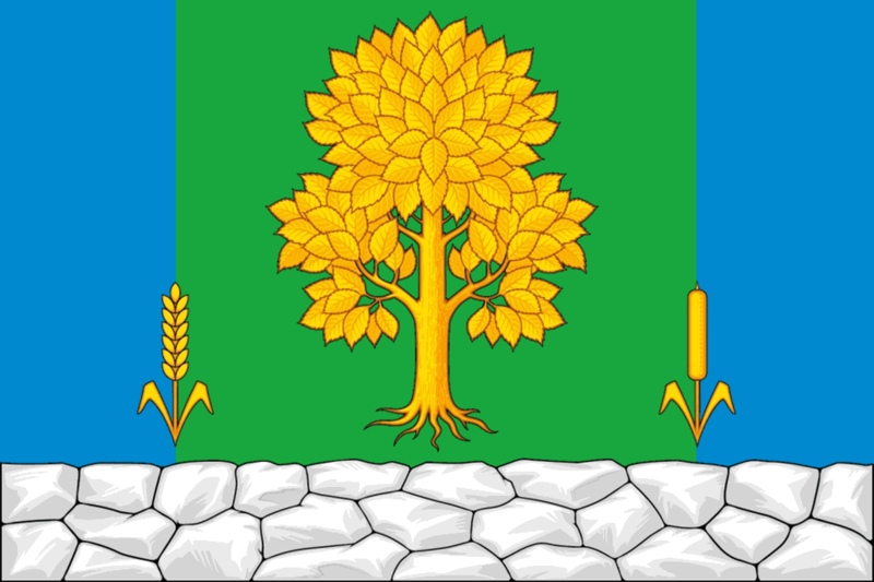
English: Flag of Topkinsky rayon, Kemerovo Oblast, Russia
Русский: Флаг Топкинского района, Кемеровская область, Россия
«Прямоугольное двухстороннее полотнище с отношением ширины к длине 2:3, воспроизводящее фигуры из герба Топкинского муниципального района, выполненные синим, зелёным, жёлтым и белым цветом». Описание герба: «В зелёном поле над серебряной сложенной из глыб оконечностью — золотой тополь с видимыми корнями между лазоревыми узкими включёнными краями, пониженно сопровождённый положенными поверх границ краёв золотым хлебным колосом и рогозом того же металла». |
||||
| Date | |||||
| Source | Решение Совета народных депутатов Топкинского муниципального района от 24.04.2018 № 79 «Об официальных символах (гербе и флаге) Топкинского муниципального района» | ||||
| Author | Сергей Синицын, Юрий Фрейман, Константин Мочёнов, Анна Гарсия, Ольга Френкель | ||||
| Permission (Reusing this file) |
|

File history
Click on a date/time to view the file as it appeared at that time.
| Date/Time | Thumbnail | Dimensions | User | Comment | |
|---|---|---|---|---|---|
| current | 16:48, 29 March 2019 | | 900 × 600 (90 KB) | Permjak (talk | contribs) | {{Information |Description = {{en|Flag of Topkinsky rayon, Kemerovo Oblast, Russia}} {{ru|Флаг Топкинского района, Кемеровская область, Россия}} {{Quote box|«Прямоугольное двухстороннее полотнище с отношением ширины к длине 2:3, воспроизводящее фигуры из герба Топкинского муниципального района, выполненные синим, зелёным, жёлтым и белым цветом». Описание герба: «В зелёном поле над серебряной сложенной из глыб оконечностью — золотой тополь с видимыми корнями между лазоревыми узкими включённым... |
You cannot overwrite this file.
File usage on Commons
The following 3 pages use this file:
File usage on other wikis
The following other wikis use this file:
- Usage on ce.wikipedia.org
- Usage on cs.wikipedia.org
- Usage on cv.wikipedia.org
- Usage on en.wikipedia.org
- Usage on fa.wikipedia.org
- Usage on hu.wikipedia.org
- Usage on hy.wikipedia.org
- Usage on it.wikipedia.org
- Usage on ru.wikipedia.org
- Кемеровская область
- Топки
- Топкинский район
- Административно-территориальное деление Кемеровской области
- Соломино (Кемеровская область)
- Подонино
- Флаги Кемеровской области
- Шаблон:Населённые пункты Топкинского муниципального округа
- Зарубино (Кемеровская область)
- Глубокое (Кемеровская область)
- Медынино
- 115 км
- 123 км
- 13 км (Кемеровская область)
- 130 км
- 137 км
- 15 км (Кемеровская область)
- 64 км
- 79 км (разъезд)
- 96 км
- Бархатово (Кемеровская область)
- Большой Корчуган (деревня)
- Бурухино
- Верх-Мостовинский
- Верх-Падунский
- Дедюево (деревня)
- Дедюево (разъезд)
- Знаменский (Кемеровская область)
- Катково (Кемеровская область)
- Ключевой (Топкинский район)
- Козлово (Кемеровская область)
- Кокуй (Топкинский район)
- Комсомольский (Кемеровская область)
- Корниловка (Кемеровская область)
- Левососновский
- Листвянка (Топкинский район)
- Лукошкино (Кемеровская область)
- Магистральный (Кемеровская область)
- Малый Корчуган (деревня)
- Мокроусовский
- Октябрьский (Топкинский район)
- Опарино (Кемеровская область)
View more global usage of this file.