File:Fiskartorpet 1680-2009.png
Jump to navigation
Jump to search

Size of this preview: 599 × 600 pixels. Other resolutions: 240 × 240 pixels | 479 × 480 pixels | 767 × 768 pixels | 1,023 × 1,024 pixels | 1,376 × 1,378 pixels.
Original file (1,376 × 1,378 pixels, file size: 347 KB, MIME type: image/png)
Captions
Captions
Add a one-line explanation of what this file represents
Summary
[edit]
| Description |
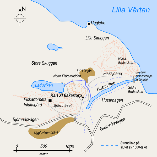
English: Area around Fiskartorpet, Norra Djurgården, Stockholm. Simplified map with historical names showing the place for King Karl XI's fishing cottage, built around 1680. |
| Date | |
| Source | Old maps and estimated historical water front |
| Author | Lidingo |
| Permission (Reusing this file) |
I, the copyright holder of this work, hereby publish it under the following license: This file is licensed under the Creative Commons Attribution-Share Alike 3.0 Unported license.
|
| Other versions | File:Fiskartorpet_historical_names.jpg (adjusted colors in present file) |
File history
Click on a date/time to view the file as it appeared at that time.
| Date/Time | Thumbnail | Dimensions | User | Comment | |
|---|---|---|---|---|---|
| current | 08:18, 14 October 2010 | | 1,376 × 1,378 (347 KB) | Holger.Ellgaard (talk | contribs) | kompl med skala |
| 21:57, 2 March 2009 |  | 1,518 × 1,427 (280 KB) | Lidingo (talk | contribs) | {{Information |Description={{en|1=Area around Fiskartorpet, Djurgården north, Stockholm. Simplified map with historical names showing the place for King Karl XI's fishing cottage, built around 1680.}} |Source=Old maps and estimated historical water front |
You cannot overwrite this file.
File usage on Commons
The following 2 pages use this file:
File usage on other wikis
The following other wikis use this file:
- Usage on sv.wikipedia.org
- Usage on www.wikidata.org