File:Fisheye lenses-HDR Technique- Qavam House-Shiraz-Iran باغ نارنجستان قوام خانه قوام السلطنه در شیراز.jpg
Jump to navigation
Jump to search

Size of this preview: 800 × 533 pixels. Other resolutions: 320 × 213 pixels | 640 × 427 pixels | 1,024 × 683 pixels | 1,280 × 853 pixels | 2,560 × 1,707 pixels | 6,720 × 4,480 pixels.
Original file (6,720 × 4,480 pixels, file size: 20.48 MB, MIME type: image/jpeg)
Captions
Captions
Add a one-line explanation of what this file represents
Summary
[edit]| Description |
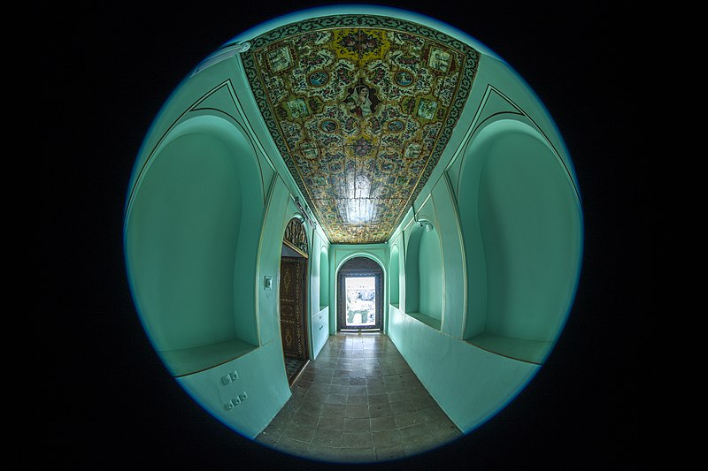
فارسی: قوام السلطنه در سال ۱۲۵۲ ه. ق به حکومت فارس منصوب گردید و در محله سکونت خویش (محله بالاکفت) اقدام به احداث ابنیه تاریخی و سکونتی نمود که به شکل گیری مجموعه قوام منجر گردید. این مجموعه که در بین عامه مردم به باغ قوام معروف است بواسطه نام بنای بیرونی خود امروز به نارنجستان قوام معروف است.
English: Qavam Pavilion in Shiraz, Iran. It is at walking distance from the Khan Madrassa.
العربية: حديقة نارنجستان قوام هي واحدة من الحدائق التاريخية في إيران. حيث يعود إنشائها إلى الحقبة القاجارية في مدينة شيراز التي تُعَد من المدن التي تكثر فيها الحدائق الغناء والبساتين والغابات والشقائق التي تستقطب السائحين. وتُعتبَر هذه الحديقة والأبنية داخلها من الأماكن الثمينة وذلك بسبب عمرها التأريخي العريق الذي يعود إلى القرن التاسع عشر.[3] لقد سميت هذه الحديقة بنارنجستان أي (حديقة النارنج) وذلك بسبب كثرة اشجار النارنج فيها.
Deutsch: Der Bagh-e Narandschestan ist die kleinste Gartenanlage in Schiras. Wie der persische Name verrät, handelt es sich um einen Orangengarten. Im Garten befindet sich der Narandschestan-e Ghavam-Pavillon
Français : La Maison Qavam ou Narenjestan e Ghavam est une résidence historique et traditionnelle persane située à Chiraz en Iran, près de la médersa du Khan.
Italiano: La Casa Qavam (anche ampiamente chiamata Narenjestan e Ghavam) è una casa tradizionale e storica a Shiraz in Iran. È a pochi passi dalla Madrassa del Khan e all'interno del giardino Eram.
Nederlands: Het Qavamhuis of Narenjestan e Ghavam ("sinaasappelgaard van Ghavam") is een historisch huis in de Eramtuin in de Iraanse stad Shiraz.
|
||
| Date | |||
| Source | Own work | ||
| Author | Mostafameraji | ||
| Other versions |
.jpg)
| Camera location | | View this and other nearby images on: OpenStreetMap |
|---|
Licensing
[edit]
I, the copyright holder of this work, hereby publish it under the following license:
This file is licensed under the Creative Commons Attribution-Share Alike 4.0 International license.
- You are free:
- to share – to copy, distribute and transmit the work
- to remix – to adapt the work
- Under the following conditions:
- attribution – You must give appropriate credit, provide a link to the license, and indicate if changes were made. You may do so in any reasonable manner, but not in any way that suggests the licensor endorses you or your use.
- share alike – If you remix, transform, or build upon the material, you must distribute your contributions under the same or compatible license as the original.

|
This image was uploaded as part of Wiki Loves Monuments 2017.
|
 |
File history
Click on a date/time to view the file as it appeared at that time.
| Date/Time | Thumbnail | Dimensions | User | Comment | |
|---|---|---|---|---|---|
| current | 08:39, 3 October 2017 | | 6,720 × 4,480 (20.48 MB) | Mostafameraji (talk | contribs) | User created page with UploadWizard |
You cannot overwrite this file.
File usage on Commons
The following page uses this file: