File:First Voyage Round The World Straits.jpg
Jump to navigation
Jump to search

Size of this preview: 377 × 599 pixels. Other resolutions: 151 × 240 pixels | 302 × 480 pixels | 483 × 768 pixels | 644 × 1,024 pixels | 1,485 × 2,360 pixels.
Original file (1,485 × 2,360 pixels, file size: 640 KB, MIME type: image/jpeg)
Captions
Captions
Add a one-line explanation of what this file represents
Summary
[edit]
| Description |
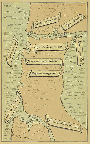
English: Pigafetta's map of Magellan's Straits, from The First Voyage round the World, by Magellan. |
| Date | |
| Source | https://archive.org/details/firstvoyageround00piga |
| Author | Henry Edward John Stanley, Baron Stanley, 1827-1903 |
Licensing
[edit]
|
The author died in 1903, so this work is in the public domain in its country of origin and other countries and areas where the copyright term is the author's life plus 100 years or fewer. This work is in the public domain in the United States because it was published (or registered with the U.S. Copyright Office) before January 1, 1929. | |
| This file has been identified as being free of known restrictions under copyright law, including all related and neighboring rights. | |
File history
Click on a date/time to view the file as it appeared at that time.
| Date/Time | Thumbnail | Dimensions | User | Comment | |
|---|---|---|---|---|---|
| current | 20:12, 1 September 2013 | | 1,485 × 2,360 (640 KB) | Keith Edkins (talk | contribs) | == {{int:filedesc}} == {{Information |Description={{En|1=Pigafetta's map of Magellan's Straits, from The First Voyage round the World, by Magellan.}} |date=1874 |Source=http://archive.org/details/firstvoyageround00piga |Author=Henry Edward John Stanley... |
You cannot overwrite this file.
File usage on Commons
The following page uses this file:
File usage on other wikis
The following other wikis use this file: