File:First Geologic Map of Mars 1978.jpg
Original file (5,603 × 4,479 pixels, file size: 3.58 MB, MIME type: image/jpeg)
Captions
Captions
Summary
[edit]
| Description |
English: Information from USGS Public Information Office, PIO No. 78-77 release statement, dated July 19, 1978: First Geological Map of Mars.
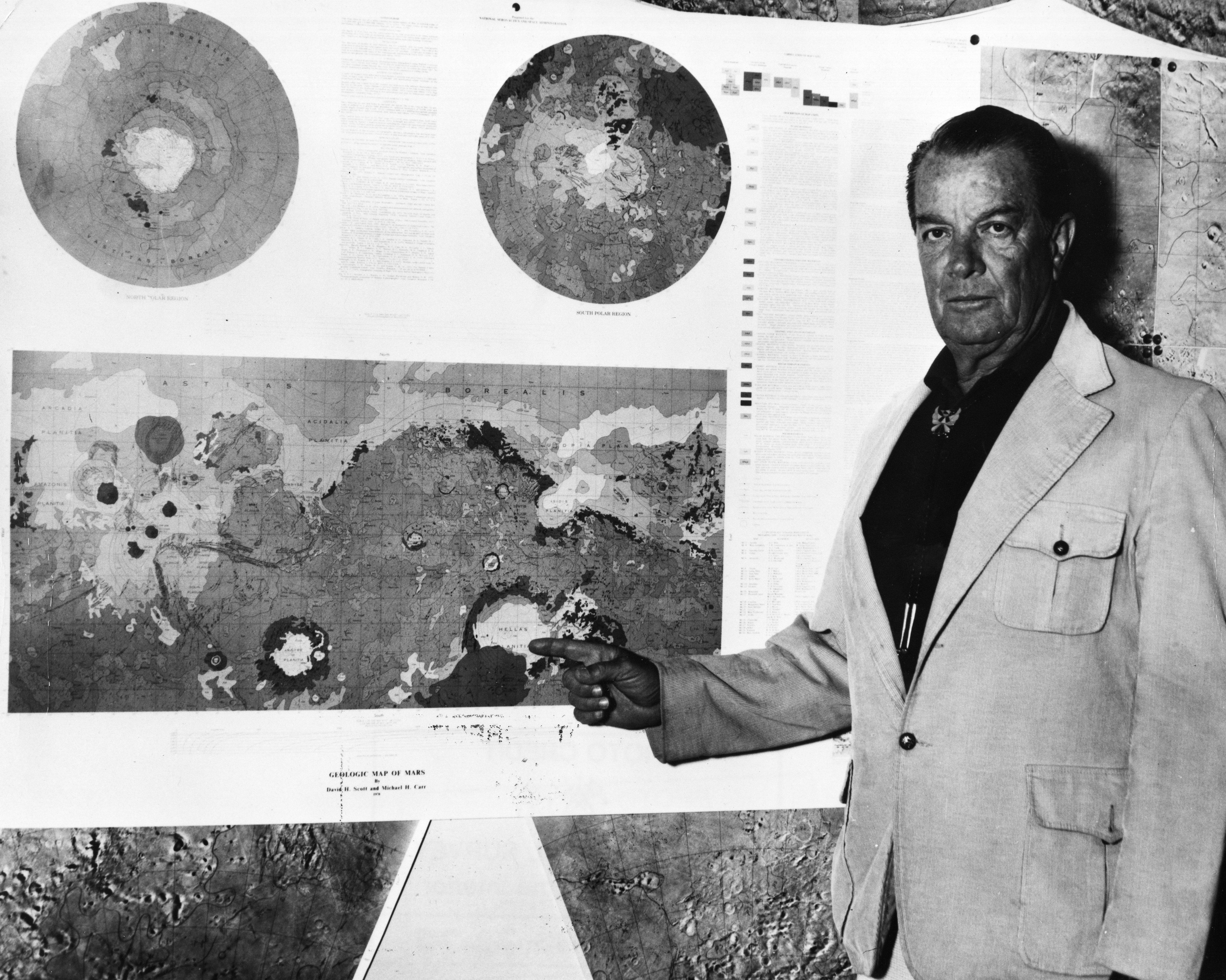
Dr. David H., Scott, geologist at the U.S. Geological Survey's Center of Astrogeology, Flagstaff, Arizona, points to the first geologic map of the entire surface of the planet Mars. The full color map show the distribution of the various kinds of rock materials, landforms, and structures - mountains, craters, plains, channels, canyons, faults, and fractures - that characterize the planet, and covers a total area of about 55,700,000 square miles or more than 18 times the area of the conterminous (48) United States at a scale of 1:25,000,000 (1 inch to about 400 miles). The map was prepared by Scott and USGS colleague geologist Dr. Michael H. Carr, of the Survey's Menlo Park, California field center, based upon detailed studies of more than 2,000 photographs of the Martian surface taken by Mariner 9 spacecraft in 1971-72. Scott served as project chief for the Mars geologic mapping program, which was funded by NASA's Planetology Program Office. The program included contributions from more than 30 planetary geologists representing 15 universities and research centers in the United States, England, and Germany. Scott said the map represents the first systematic attempt to classify the diverse rock formations of the planet into a time sequence, allowing the evolutionary history of the surface of Mars to be more clearly understood. A variety of colors and tints are used on the map to differentiate a total of 23 types of rock units as well as the great variety of geologic structures that mark the surface of Mars. The colors also provide clues to the relative ages of the rock units and features. The features on Mars, including huge volcanic mountains, immense channel and valley systems, and extensive lava plains, suggest a planet with exciting geologic history, and one that may have resembled our own Earth in ages past more than any other member of the solar system, Scott said. In the photo, Scott is pointing to one of the many unusual features depicted on the geologic map - a huge basin, Hellas, about 1,400 miles in diameter, and formed by the impact of a large asteroid. |
| Date | |
| Source | First Geologic Map of Mars. 1978. |
| Author | USGS |
Licensing
[edit]
This image is in the public domain in the United States because it only contains materials that originally came from the United States Geological Survey, an agency of the United States Department of the Interior. For more information, see the official USGS copyright policy.
|
File history
Click on a date/time to view the file as it appeared at that time.
| Date/Time | Thumbnail | Dimensions | User | Comment | |
|---|---|---|---|---|---|
| current | 18:39, 16 April 2024 | | 5,603 × 4,479 (3.58 MB) | Jstuby (talk | contribs) | Uploaded a work by USGS from [https://library.usgs.gov/photo/index.html#/item/5d4b0727e4b01d82ce8df27d First Geologic Map of Mars. 1978.] with UploadWizard |
You cannot overwrite this file.
File usage on Commons
There are no pages that use this file.
File usage on other wikis
The following other wikis use this file:
- Usage on en.wikipedia.org