File:Fires in Queensland, Australia (MODIS 2024-07-26).jpg

Original file (2,682 × 2,059 pixels, file size: 554 KB, MIME type: image/jpeg)
Captions
Captions
Summary
[edit].jpg&action=edit§ion=1)
| Description |
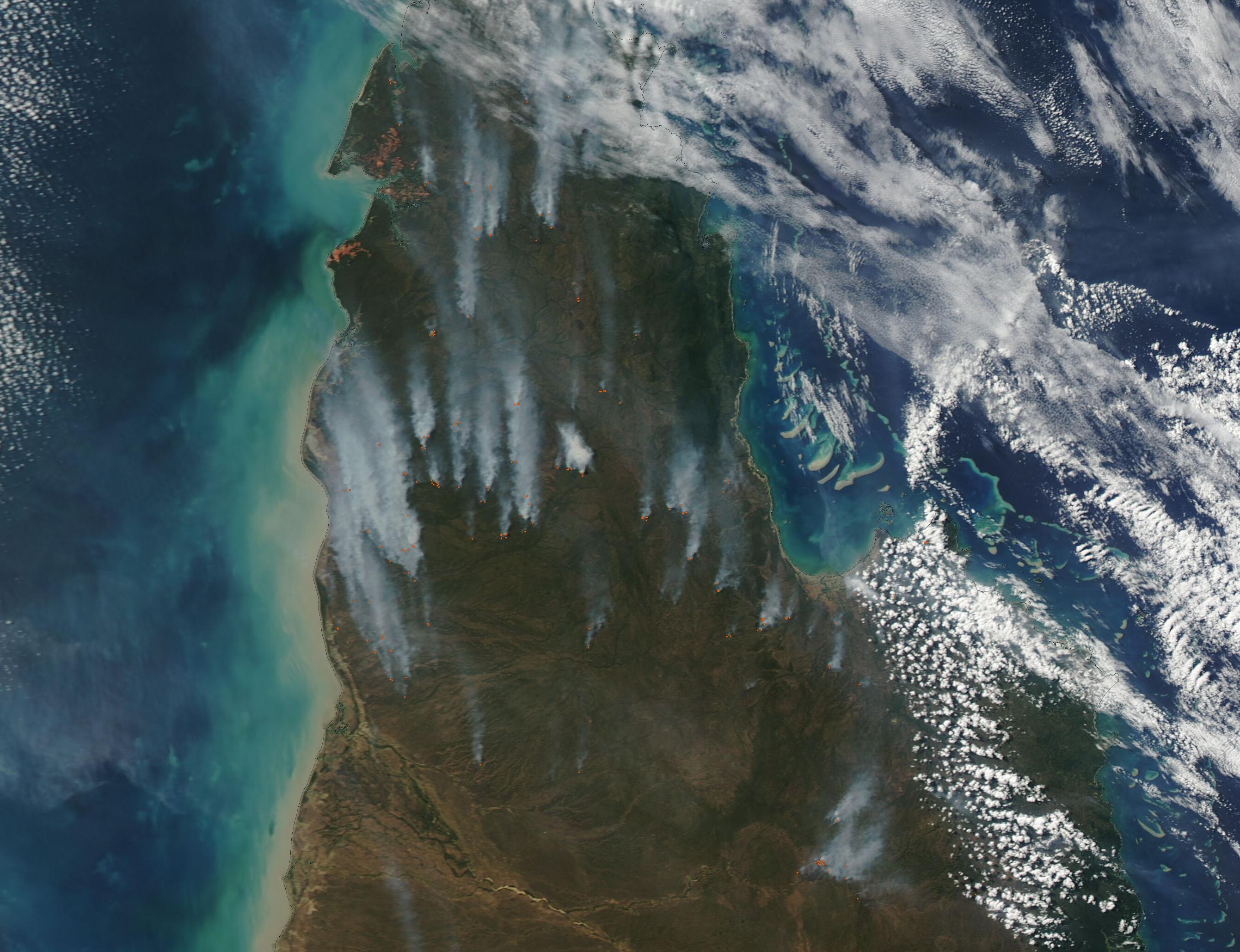
English: On July 17, 2024, the Moderate Resolution Imaging Spectroradiometer (MODIS) on NASA’s Aqua satellite acquired a dramatic true-color image of multiple fires burning across Cape York Peninsula in Queensland, Australia. Each active fire is marked by a red “hot spot”. Copious gray smoke rises from the fires and is blown northward by strong, steady winds.
Cape York Peninsula is globally significant as one of the last great Wet/Dry tropical systems in the world and is sometimes referred to as one of the largest unspoiled wilderness areas in the world, according to the Cape York National Resource Management website. While the ecosystem remains relatively intact, it still is home to people, agriculture, and is widely under management to retain a healthy ecosystem. Bushfires can occur at any time of the year, but the fire season in Cape York typically starts in August and runs through December, during the driest time of the year. At that time, bushfires can roar across as much as seventy percent of the Cape, causing considerable damage. To try to avoid disastrous bushfires and to help keep the ecosystem and residents safe, prescribed burning is widely used across much of Australia, including Cape York Peninsula. These burns, also called Hazard Burns, are intentionally lit, managed, then doused when the desired burn has been completed. July is peak fire management season in this region, as the grasses are at peak growth but are not yet so dry as to easily feed out of control spread. While it’s not possible to know the cause of a fire just by satellite imagery, it is likely that most of the fires visible in this image are prescribed burns, not wild bushfires. The Queensland Fire Department website lists many dozens of Hazard Burn Notifications as of July 25, with dates going back to mid-July. |
||
| Date | Taken on 17 July 2024 | ||
| Source |
Fires in Queensland, Australia (direct link)
|
||
| Author | MODIS Land Rapid Response Team, NASA GSFC |
| This media is a product of the Aqua mission Credit and attribution belongs to the mission team, if not already specified in the "author" row |
Licensing
[edit].jpg&action=edit§ion=2)
| This file is in the public domain in the United States because it was solely created by NASA. NASA copyright policy states that "NASA material is not protected by copyright unless noted". (See Template:PD-USGov, NASA copyright policy page or JPL Image Use Policy.) | ||
 |
Warnings:
|
File history
Click on a date/time to view the file as it appeared at that time.
| Date/Time | Thumbnail | Dimensions | User | Comment | |
|---|---|---|---|---|---|
| current | 05:05, 26 July 2024 | | 2,682 × 2,059 (554 KB) | OptimusPrimeBot (talk | contribs) | #Spacemedia - Upload of http://modis.gsfc.nasa.gov/gallery/images/image07262024_250m.jpg via Commons:Spacemedia |
You cannot overwrite this file.
File usage on Commons
There are no pages that use this file.
.jpg&oldid=903398691)