File:Fires in Drought-Stricken Brazil (MODIS).jpg

Original file (6,007 × 4,651 pixels, file size: 2.73 MB, MIME type: image/jpeg)
Captions
Captions
Summary
[edit].jpg&action=edit§ion=1)
| Description |
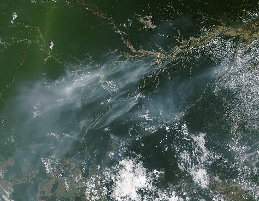
English: A cloud of thick smoke hung over many dozens of fires burning in Brazil on October 9, 2023, when the Moderate Resolution Imaging Spectroradiometer (MODIS) on NASA’s Terra satellite acquired a true-color image of the region.
The state of Amazonas fills most of the west in this image, and part of the state of Pará can be seen in the east. Red “hot spots” mark areas where the thermal bands detected high temperatures, typical of actively burning fire. Numerous hot spots are scattered throughout green rainforest but are especially thick along the course of the Amazon River and its tributaries. The high number of fires, the time of year, and the widespread distribution suggest that most of these fires have been deliberately set to manage land or clear new land for use. Deforestation in Brazil has been intense, especially in the last several years, as industry and agriculture expands in search of profit. However, with the region currently experiencing extreme drought, it is also likely that some of these are wildfires. According to a bulletin published by ReliefWeb, “On 26 September 2023, Civil Protection of the state of Amazonas in Brazil reported that there were 111,000 people affected by the drought in the state and 15 municipalities out of 62 have declared a State of Emergency due to the drought. On 12 September 2023, the Governor of Amazonas signed a decree declaring a state of environmental emergency in municipalities in southern Amazonas and metropolitan Manaus, the capital. The Government published the action plan for Operation Drought 2023, involving 30 agencies from the direct and indirect administration of the Government of Amazonas, with an estimated R$100 million in actions.” Media reports that the Rio Negro and parts of the Amazon River have been at record lows since early September, causing rivers and lakes to shrink to a fraction of their size. A floating village in Lake Puraquequara, east of the city of Manaus, was said to be entirely marooned in mud while some residents dug wells in the cracked lakebed to reach water. The dry conditions not only are a threat to the health and welfare of people, livestock, agriculture, and travel along the rivers, they also create conditions ripe for wildfires to spark and spread. |
||
| Date | Taken on 9 October 2023 | ||
| Source |
Fires in Drought-Stricken Brazil (direct link)
|
||
| Author | MODIS Land Rapid Response Team, NASA GSFC |
| This media is a product of the Terra mission Credit and attribution belongs to the mission team, if not already specified in the "author" row |
Licensing
[edit].jpg&action=edit§ion=2)
| This file is in the public domain in the United States because it was solely created by NASA. NASA copyright policy states that "NASA material is not protected by copyright unless noted". (See Template:PD-USGov, NASA copyright policy page or JPL Image Use Policy.) | ||
 |
Warnings:
|
File history
Click on a date/time to view the file as it appeared at that time.
| Date/Time | Thumbnail | Dimensions | User | Comment | |
|---|---|---|---|---|---|
| current | 05:05, 12 October 2023 | | 6,007 × 4,651 (2.73 MB) | OptimusPrimeBot (talk | contribs) | #Spacemedia - Upload of http://modis.gsfc.nasa.gov/gallery/images/image10122023_250m.jpg via Commons:Spacemedia |
You cannot overwrite this file.
File usage on Commons
There are no pages that use this file.
.jpg&oldid=910296764)