File:Finland Regions Map Numbered.svg
Jump to navigation
Jump to search

Size of this PNG preview of this SVG file: 344 × 599 pixels. Other resolutions: 138 × 240 pixels | 276 × 480 pixels | 441 × 768 pixels | 588 × 1,024 pixels | 1,176 × 2,048 pixels | 1,850 × 3,220 pixels.
Original file (SVG file, nominally 1,850 × 3,220 pixels, file size: 125 KB)
Captions
Captions
Add a one-line explanation of what this file represents

|
This file has been superseded by Finland ISO 3166-2 Regions Map.svg. It is recommended to use the other file. Please note that deleting superseded images requires consent.
|

|
| Description |
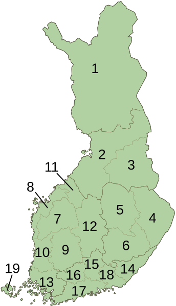
English: Numbered map of Finland divided into its 19 regions.
Suomi: Numeroitu kartta Suomen maakunnista |
| Date | 27 March 2011, 10:41 (UTC) |
| Source | |
| Author |
|
| Other versions |
 |
| This is a retouched picture, which means that it has been digitally altered from its original version. Modifications: Numbered. The original can be viewed here: Finland Regions Map.svg:
|
I, the copyright holder of this work, hereby publish it under the following license:
| I, the copyright holder of this work, release this work into the public domain. This applies worldwide. In some countries this may not be legally possible; if so: I grant anyone the right to use this work for any purpose, without any conditions, unless such conditions are required by law. |
Reference
[edit]
| Number | Finnish/Suomi | Swedish/Svenska | English (click link for Category) |
|---|---|---|---|
| 19 | Ahvenanmaa | Åland | Åland |
| 14 | Etelä-Karjala | Södra Karelen | South Karelia |
| 7 | Etelä‑Pohjanmaa | Södra Österbotten | Southern Ostrobothnia |
| 6 | Etelä-Savo | Södra Savolax | Southern Savonia |
| 3 | Kainuu | Kajanaland | Kainuu |
| 16 | Kanta-Häme | Egentliga Tavastland | Tavastia Proper |
| 18 | Kymenlaakso | Kymmenedalen | Kymenlaakso |
| 1 | Lappi | Lappland | Lapland |
| 11 | Keski‑Pohjanmaa | Mellersta Österbotten | Central Ostrobothnia |
| 12 | Keski-Suomi | Mellersta Finland | Central Finland |
| 9 | Pirkanmaa | Birkaland | Pirkanmaa |
| 8 | Pohjanmaa | Österbotten | Ostrobothnia |
| 4 | Pohjois-Karjala | Norra Karelen | North Karelia |
| 2 | Pohjois‑Pohjanmaa | Norra Österbotten | Northern Ostrobothnia |
| 5 | Pohjois-Savo | Norra Savolax | Northern Savonia |
| 15 | Päijät-Häme | Päijänne Tavastland | Päijänne Tavastia |
| 10 | Satakunta | Satakunda | Satakunta |
| 17 | Uusimaa | Nyland | Uusimaa |
| 13 | Varsinais‑Suomi | Egentliga Finland | Finland Proper |
Original upload log
[edit]
This image is a derivative work of the following images:
- File:Finland_Regions_Map.svg licensed with PD-self
- 2011-01-07T21:57:06Z Fallschirmjäger 1850x3220 (114384 Bytes) Corrected borders of Uusimaa
- 2011-01-07T19:55:54Z Fallschirmjäger 1850x3220 (114905 Bytes) == {{int:filedesc}} == {{Information |Description={{en|1=Blank map of Finland divided into its regions.}}{{fi|1=Suomen maakunnat}} |Source=[[:File:Suomen maakunnat.svg]] |Author=[[User:Fallschirmjäger|Fallschirmjäger]] |Dat
Uploaded with derivativeFX
File history
Click on a date/time to view the file as it appeared at that time.
| Date/Time | Thumbnail | Dimensions | User | Comment | |
|---|---|---|---|---|---|
| current | 10:43, 27 March 2011 | | 1,850 × 3,220 (125 KB) | Apalsola (talk | contribs) | {{Information |Description= {{en|1=Numbered map of Finland divided into its 19 regions.}} {{fi|1=Numeroitu kartta Suomen maakunnista}} |Source=*File:Finland_Regions_Map.svg |Date={{ISOdate|2011-03-27 10:41}} (UTC) |Author=*[[:File:Finland_Regions_Ma |
You cannot overwrite this file.
File usage on Commons
The following page uses this file:
File usage on other wikis
The following other wikis use this file:
- Usage on eo.wikipedia.org
- Usage on fr.wikipedia.org
- Usage on lt.wikipedia.org
- Usage on nl.wikipedia.org
- Usage on pl.wikipedia.org
- Usage on ru.wikipedia.org
- Usage on sk.wikipedia.org
- Usage on uk.wikipedia.org
- Usage on vls.wikipedia.org