File:Findon St John from NW GeoUK 3499679.jpg
Jump to navigation
Jump to search

Size of this preview: 454 × 600 pixels. Other resolutions: 182 × 240 pixels | 363 × 480 pixels | 581 × 768 pixels | 1,158 × 1,530 pixels.
Original file (1,158 × 1,530 pixels, file size: 231 KB, MIME type: image/jpeg)
Captions
Captions
Add a one-line explanation of what this file represents
Summary
[edit]| Description |
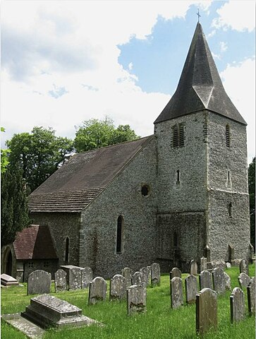
St John the Baptist Church: |
| Date | |
| Source |
This file was derived from: St John the Baptist Church, Findon, West Sussex - geograph.org.uk - 3499679.jpg |
| Author | Simon Care |
| Other versions |
|

| Camera location | | View this and other nearby images on: OpenStreetMap |
|---|
_heading:112.00&language=en)
| Object location | | View this and other nearby images on: OpenStreetMap |
|---|
_heading:112.00&language=en)
Licensing
[edit]
This file is licensed under the Creative Commons Attribution-Share Alike 2.0 Generic license.
- You are free:
- to share – to copy, distribute and transmit the work
- to remix – to adapt the work
- Under the following conditions:
- attribution – You must give appropriate credit, provide a link to the license, and indicate if changes were made. You may do so in any reasonable manner, but not in any way that suggests the licensor endorses you or your use.
- share alike – If you remix, transform, or build upon the material, you must distribute your contributions under the same or compatible license as the original.
File history
Click on a date/time to view the file as it appeared at that time.
| Date/Time | Thumbnail | Dimensions | User | Comment | |
|---|---|---|---|---|---|
| current | 16:00, 17 June 2023 | | 1,158 × 1,530 (231 KB) | Ulamm (talk | contribs) | {{Information |Description=St John the Baptist Church:<br /> Findon's parish church dates from the 11th century and has been added and altered over the following centuries, the last major overhaul coming in 1866-67. The old settlement of Findon once stood to the immediate north of the church but was in its current location by the 16th century. This subsequently left the church and manor house some distance from the rest of the settlement its isolation completed when the Findon By-Pass was con... |
You cannot overwrite this file.
File usage on Commons
The following 2 pages use this file:
File usage on other wikis
The following other wikis use this file:
- Usage on de.wikipedia.org