File:Filipovský pramen řeky Chrudimky, CZ170408-022.jpg
![File:Filipovský pramen řeky Chrudimky, CZ170408-022.jpg](https://upload.wikimedia.org/wikipedia/commons/thumb/a/a3/Filipovsk%C3%BD_pramen_%C5%99eky_Chrudimky%2C_CZ170408-022.jpg/800px-Filipovsk%C3%BD_pramen_%C5%99eky_Chrudimky%2C_CZ170408-022.jpg?20180102121437)
Original file (4,827 × 2,752 pixels, file size: 5.18 MB, MIME type: image/jpeg)
Captions
Captions
Summary
[edit]DescriptionFilipovský pramen řeky Chrudimky, CZ170408-022.jpg |
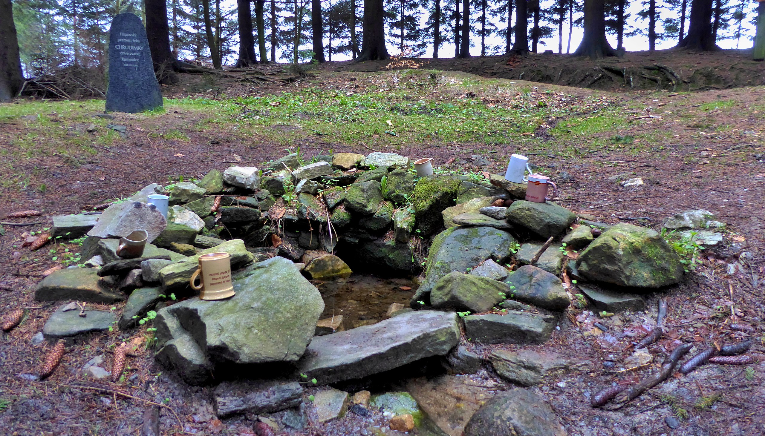
English: The "Filipovský" spring is the main source of the river Chrudimka with natural spring of the groundwater on the Earth's surface at aproximallity an altitude of 705 m at the edge of the forest locality with name "Humperky" in the landscape area of the Iron Mountains, within the administrative division in the cadastral area of the Krouna municipality in the Chrudim district, belonging to the Pardubice Region in the Czech Republic. The river is springing approximately 750 m away northwest of the highest peak of the Iron Mountains with the geographical name "U oběšeného" (737.4 m), with the local name "Na panenkách". From the point of view of the regional divide georelief of the Czech Republic springs "Chrudimka" in the geomorphological district "Kameničská" highlands, this is of the part of the "Sečská" Highlands in the southeast part of the Iron Mountains. The river has more springs in the area at the village "Kameničky", above the settlement Filipov (from it the name of the source "Filipovský"). From the point of view of hydrology, the most important source of the Chrudimka river. The geographical name of the river comes from the town of Chrudim and has been used since the 17th century. Photo location: Czechia, Pardubice Region, municipality Krouna, forest locality Humperky, "Filipovský" spring.
Čeština: Filipovský pramen je hlavní pramennou zdrojnicí řeky Chrudimky s přírodním vývěrem podzemní vody na zemský povrch přibližně v nadmořské výšce 705 m na okraji lesní lokality Humperky v krajinné oblasti Železných hor, v rámci administrativně správním na katastrálním území obce Krouna v okrese Chrudim, náležejícím do Pardubického kraje v České republice. Řeka pramení přibližně 750 m severozápadně od nejvyššího vrcholu Železných hor se zeměpisným jménem (oronymum) U oběšeného (737,4 m) a s místním názvem (oikonymum) Na panenkách. Z hlediska regionálního členění georeliéfu Česka pramení Chrudimka v geomorfologickém okrsku Kameničská vrchovina, ten je součástí Sečské vrchoviny v jihovýchodní části pohoří Železných hor. Filipovský pramen je jedním z více pramenných zdrojů rozsáhlého prameniště Chrudimky v oblasti Kameniček, nad vesničkou Filipov, od ní název pramene "Filipovský". Z pohledu hydrologie je nevýznamnějším a také nejvýše položeným pramenným zdrojem řeky Chrudimky. Zeměpisný název řeky je odvozený od města Chrudim, kterým protéká v dolním toku, začalo se ho užívat v průběhu 17. století. Foto lokace: Česko, Pardubický kraj, obec Krouna, Kameničská vrchovina, lesní lokalita Humperky, Filipovský pramen (150°). |
Date | |
Source | Own work |
Author | Josef Kreuz (PEPan) |
Camera location | 49° 44′ 15.72″ N, 16° 00′ 42.68″ E ![]() ![]() | View this and other nearby images on: OpenStreetMap | ![]() |
---|
Externí odkazy:
[edit]- Základní mapa Česka – kompozice Filipovský pramen řeky Chrudimky viz
- Turistická mapa – kompozice Filipovský pramen řeky Chrudimky (letecký pohled) viz
- CS Wkipedie – heslo Filipovský pramen viz
Licensing
[edit]![w:en:Creative Commons](https://upload.wikimedia.org/wikipedia/commons/thumb/7/79/CC_some_rights_reserved.svg/90px-CC_some_rights_reserved.svg.png)
![attribution](https://upload.wikimedia.org/wikipedia/commons/thumb/1/11/Cc-by_new_white.svg/24px-Cc-by_new_white.svg.png)
![share alike](https://upload.wikimedia.org/wikipedia/commons/thumb/d/df/Cc-sa_white.svg/24px-Cc-sa_white.svg.png)
- You are free:
- to share – to copy, distribute and transmit the work
- to remix – to adapt the work
- Under the following conditions:
- attribution – You must give appropriate credit, provide a link to the license, and indicate if changes were made. You may do so in any reasonable manner, but not in any way that suggests the licensor endorses you or your use.
- share alike – If you remix, transform, or build upon the material, you must distribute your contributions under the same or compatible license as the original.
File history
Click on a date/time to view the file as it appeared at that time.
Date/Time | Thumbnail | Dimensions | User | Comment | |
---|---|---|---|---|---|
current | 12:14, 2 January 2018 | ![]() | 4,827 × 2,752 (5.18 MB) | PEPan (talk | contribs) | User created page with UploadWizard |
You cannot overwrite this file.
File usage on Commons
The following page uses this file:
File usage on other wikis
The following other wikis use this file:
- Usage on cs.wikipedia.org
- Usage on www.wikidata.org
Metadata
This file contains additional information such as Exif metadata which may have been added by the digital camera, scanner, or software program used to create or digitize it. If the file has been modified from its original state, some details such as the timestamp may not fully reflect those of the original file. The timestamp is only as accurate as the clock in the camera, and it may be completely wrong.
Camera manufacturer | Panasonic |
---|---|
Camera model | DMC-TZ60 |
Author | Josef Kreuz |
Copyright holder |
|
Exposure time | 1/10 sec (0.1) |
F-number | f/3.3 |
ISO speed rating | 400 |
Date and time of data generation | 17:02, 8 April 2017 |
Lens focal length | 4.3 mm |
User comments | EN: The "Filipovský" spring is the main source of the river Chrudimka with natural spring of the groundwater on the Earth's surface at aproximallity an altitude of 708 m at the edge of the forest locality with name "Humperky" in the landscape area of the Iron Mountains, within the administrative division in the cadastral area of the Krouna municipality in the Chrudim district, belonging to the Pardubice Region in the Czech Republic. The river is springing approximately 750 m away northwest of the highest peak of the Iron Mountains with the geographical name "U oběšeného" (737.4 m), with the local name "Na panenkách". From the point of view of the regional divide georelief of the Czech Republic springs "Chrudimka" in the geomorphological district "Kameničská" highlands, this is of the part of the "Sečská" Highlands in the southeast part of the Iron Mountains. The river has more springs in the area at the village "Kameničky", above the settlement Filipov (from it the name of the source "Filipovský"). From the point of view of hydrology, the most important source of the Chrudimka river. The geographical name of the river comes from the town of Chrudim and has been used since the 17th century.
CZ: Filipovský pramen je hlavní pramennou zdrojnicí řeky Chrudimky s přírodním vývěrem podzemní vody na zemský povrch přibližně v nadmořské výšce 708 m na okraji lesní lokality Humperky v krajinné oblasti Železných hor, v rámci administrativně správním na katastrálním území obce Krouna v okrese Chrudim, náležejícím do Pardubického kraje v České republice. Řeka pramení přibližně 750 m severozápadně od nejvyššího vrcholu Železných hor se zeměpisným jménem (oronymum) U oběšeného (737,4 m) a s místním názvem (oikonymum) Na panenkách. Z hlediska regionálního členění georeliéfu Česka pramení Chrudimka v geomorfologickém okrsku Kameničská vrchovina, ten je součástí Sečské vrchoviny v jihovýchodní části pohoří Železných hor. Filipovský pramen je jedním z více pramenných zdrojů rozsáhlého prameniště Chrudimky v oblasti Kameniček, nad vesničkou Filipov, od ní název pramene "Filipovský". Z pohledu hydrologie je nevýznamnějším a také nejvýše položeným pramenným zdrojem řeky Chrudimky. Zeměpisný název řeky je odvozený od města Chrudim, kterým protéká v dolním toku, začalo se ho užívat v průběhu 17. století. Externí odkazy:
viz http://geoportal.cuzk.cz/geoprohlizec/?wmcid=28454&SID=&conf=undefined&serverconf=undefined
|
Latitude | 49° 44′ 15.72″ N |
Longitude | 16° 0′ 42.68″ E |
Short title |
|
Image title |
|
Label | Yellow |
City shown | Krouna |
Compression scheme | Uncompressed |
Pixel composition | RGB |
Orientation | Normal |
Horizontal resolution | 180 dpi |
Vertical resolution | 180 dpi |
Data arrangement | chunky format |
Software used | Zoner Photo Studio 18 |
File change date and time | 12:49, 2 January 2018 |
Y and C positioning | Centered |
Exposure Program | Normal program |
Exif version | 2.3 |
Date and time of digitizing | 17:02, 8 April 2017 |
Meaning of each component |
|
Image compression mode | 4 |
APEX exposure bias | 0 |
Maximum land aperture | 3.4453125 APEX (f/3.3) |
Metering mode | Pattern |
Light source | Unknown |
Flash | Flash did not fire, compulsory flash suppression |
Supported Flashpix version | 1 |
Color space | sRGB |
Sensing method | One-chip color area sensor |
File source | Digital still camera |
Scene type | A directly photographed image |
Custom image processing | Normal process |
Exposure mode | Auto exposure |
White balance | Auto white balance |
Digital zoom ratio | 0 |
Focal length in 35 mm film | 26 mm |
Scene capture type | Standard |
Scene control | High gain up |
Contrast | Normal |
Saturation | Normal |
Sharpness | Normal |
GPS time (atomic clock) | 15:01 |
Receiver status | Measurement in progress |
Measurement mode | 2-dimensional measurement |
Measurement precision | Fair (1.1) |
Geodetic survey data used | WGS-84 |
Name of GPS area | 䌀栀爀甀搀椀洀 |
GPS date | 8 April 2017 |
GPS tag version | 0.0.3.2 |
Keywords |
|
Writer | Josef Kreuz |
Province or state shown | Pardubický kraj |
Country shown | Česko |
Code for country shown | CZ |
Sublocation of city shown | Filipovský pramen řeky Chrudimky |