File:Figure 4. Regional archaeology and palaeohydrology of the Mundafan area.png
Jump to navigation
Jump to search
Size of this preview: 668 × 600 pixels. Other resolutions: 267 × 240 pixels | 535 × 480 pixels | 856 × 768 pixels | 1,141 × 1,024 pixels | 2,059 × 1,848 pixels.
Original file (2,059 × 1,848 pixels, file size: 9.29 MB, MIME type: image/png)
Captions
Captions
Add a one-line explanation of what this file represents
Summary
[edit]
| Description |
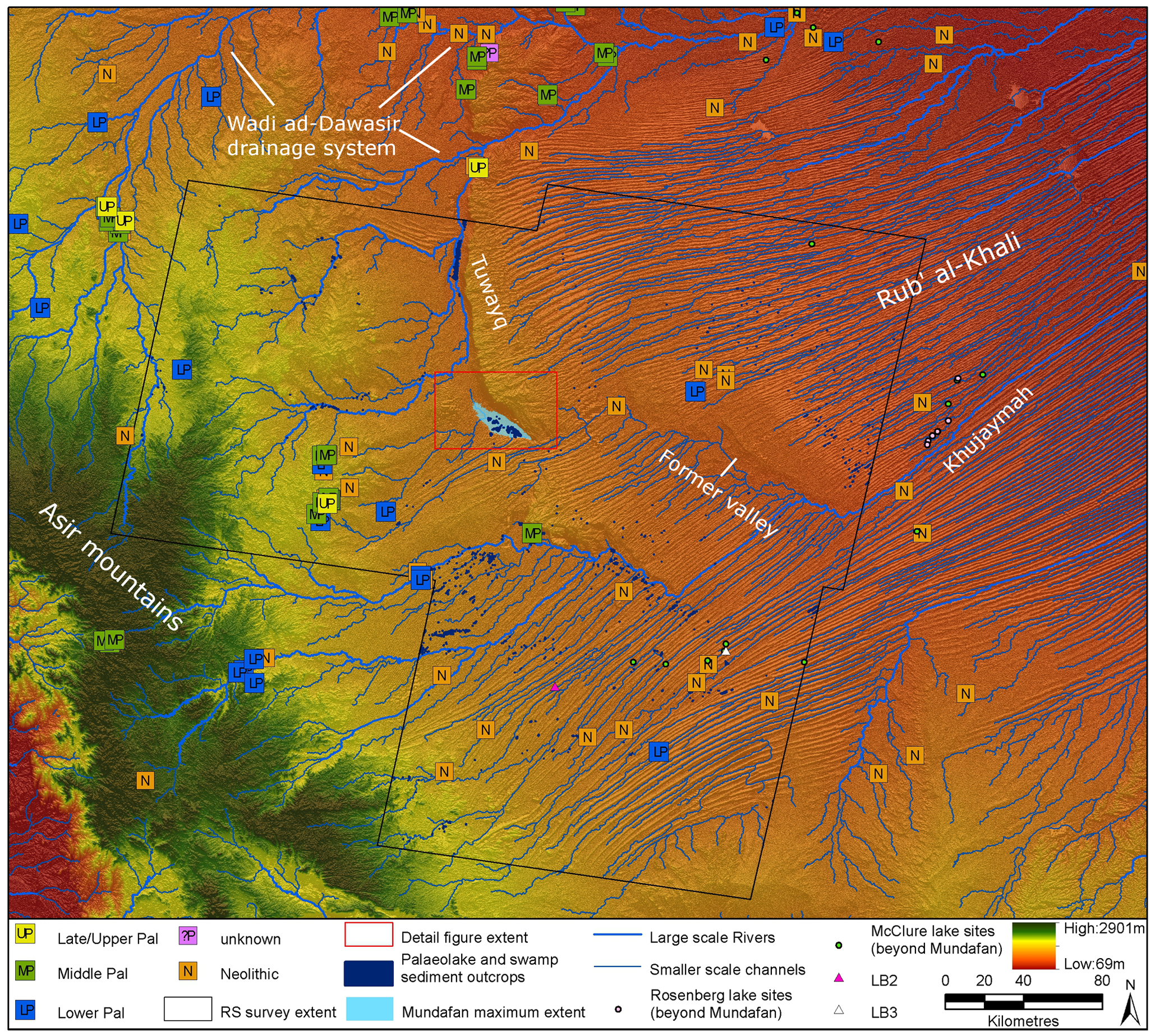
English: The remote sensing (RS) survey area is the region within which we have used the MF/SAM method to map palaeolake sediment and swamp outcrops (results displayed). Archaeological sites (by period, data from [3]), modeled drainage, the maximum recorded extent of Mundafan palaeolake [23], LB2 and LB3 site locations and published palaeolake sediment occurrences [23], [37] are displayed. All data is overlain upon SRTM V.4 elevation data [48]. |
| Date | |
| Source | Middle Palaeolithic and Neolithic Occupations around Mundafan Palaeolake, Saudi Arabia: Implications for Climate Change and Human Dispersals |
| Author | Rémy Crassard , Michael D. Petraglia, Nick A. Drake, Paul Breeze, Bernard Gratuze, Abdullah Alsharekh, Mounir Arbach, Huw S. Groucutt, Lamya Khalidi, Nils Michelsen, Christian J. Robin, Jérémie Schiettecatte |
Licensing
[edit]
This file is licensed under the Creative Commons Attribution 4.0 International license.
- You are free:
- to share – to copy, distribute and transmit the work
- to remix – to adapt the work
- Under the following conditions:
- attribution – You must give appropriate credit, provide a link to the license, and indicate if changes were made. You may do so in any reasonable manner, but not in any way that suggests the licensor endorses you or your use.
File history
Click on a date/time to view the file as it appeared at that time.
| Date/Time | Thumbnail | Dimensions | User | Comment | |
|---|---|---|---|---|---|
| current | 09:31, 13 April 2022 | | 2,059 × 1,848 (9.29 MB) | Jo-Jo Eumerus (talk | contribs) | Uploaded a work by Rémy Crassard , Michael D. Petraglia, Nick A. Drake, Paul Breeze, Bernard Gratuze, Abdullah Alsharekh, Mounir Arbach, Huw S. Groucutt, Lamya Khalidi, Nils Michelsen, Christian J. Robin, Jérémie Schiettecatte from [https://journals.plos.org/plosone/article?id=10.1371/journal.pone.0069665 Middle Palaeolithic and Neolithic Occupations around Mundafan Palaeolake, Saudi Arabia: Implications for Climate Change and Human Dispersals] with UploadWizard |
You cannot overwrite this file.
File usage on Commons
There are no pages that use this file.