File:Fig sample BSMC.jpg
Jump to navigation
Jump to search

Size of this preview: 800 × 505 pixels. Other resolutions: 320 × 202 pixels | 640 × 404 pixels | 1,024 × 647 pixels | 1,259 × 795 pixels.
Original file (1,259 × 795 pixels, file size: 110 KB, MIME type: image/jpeg)
Captions
Captions
Add a one-line explanation of what this file represents
Summary
[edit]| Description |
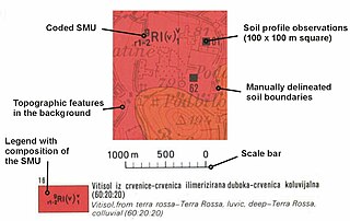
English: Soil map. |
| Date | 18 October 2005 (original upload date) |
| Source |
Hengl T., 2003. Pedometric mapping: bridging the gaps between conventional and pedometric approaches. PhD thesis, University of Wageningen, Enschede, 214 pp. |
| Author | Hengl at en.wikipedia |


Licensing
[edit]
| This work has been released into the public domain by its author, Hengl at English Wikipedia. This applies worldwide. In some countries this may not be legally possible; if so: Hengl grants anyone the right to use this work for any purpose, without any conditions, unless such conditions are required by law. |
Original upload log
[edit]
The original description page was here. All following user names refer to en.wikipedia.
- 2005-10-18 07:04 Hengl 453×286× (24130 bytes) Hengl T., 2003. Pedometric mapping: bridging the gaps between conventional and pedometric approaches. PhD thesis, University of Wageningen, Enschede, 214 pp.
- 2005-10-18 07:02 Hengl 1259×795× (113002 bytes) Hengl T., 2003. Pedometric mapping: bridging the gaps between conventional and pedometric approaches. PhD thesis, University of Wageningen, Enschede, 214 pp.
File history
Click on a date/time to view the file as it appeared at that time.
| Date/Time | Thumbnail | Dimensions | User | Comment | |
|---|---|---|---|---|---|
| current | 11:16, 20 May 2011 | | 1,259 × 795 (110 KB) | OgreBot (talk | contribs) | (BOT): This is the version originally uploaded on 2005-10-18 07:02 by Hengl; storing on commons for archival purposes |
| 21:27, 17 February 2011 |  | 453 × 286 (24 KB) | File Upload Bot (Magnus Manske) (talk | contribs) | {{BotMoveToCommons|en.wikipedia|year={{subst:CURRENTYEAR}}|month={{subst:CURRENTMONTHNAME}}|day={{subst:CURRENTDAY}}}} {{Information |Description={{en|en:Soil map.}} |Source=Transferred from [http://en.wikipedia.org en.wikipedia]; transferred to Co |
You cannot overwrite this file.
File usage on Commons
There are no pages that use this file.
File usage on other wikis
The following other wikis use this file:
- Usage on en.wikipedia.org
- Usage on es.wikipedia.org
- Usage on id.wikipedia.org