File:Fersfield Airport - geograph.org.uk - 347297.jpg
Jump to navigation
Jump to search
No higher resolution available.
Fersfield_Airport_-_geograph.org.uk_-_347297.jpg (640 × 480 pixels, file size: 119 KB, MIME type: image/jpeg)
Captions
Captions
Add a one-line explanation of what this file represents
Summary
[edit]
| Description |
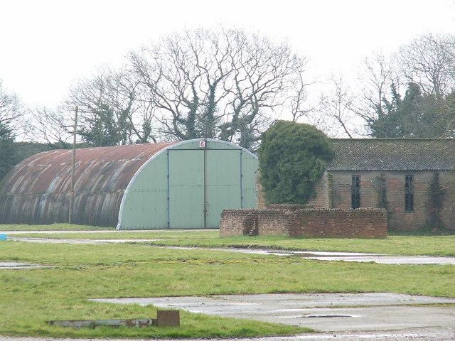
English: Fersfield Airport The airfield was a satellite of Knettishall Station and was at one time used by the 388th Bombardment Group in the joint USAAF/USN project Aphrodite to use stripped down flying fortress bombers as explosive packed, radio controlled flying bombs. Pilots would take-off manually and then parachute to safety leaving the bomber under the control of another aircraft and then flown to its target in Europe. The project was not a great success.
These buildings are being used by industry but many other buildings here are slowly deacaying and are of great interest. Find out more and see many more pictures at this website: http://8thcontrails.com/ipw-web/gallery/album43. See also TM0783 and TM0683 |
| Date | |
| Source | From geograph.org.uk |
| Author | Richard Rice |
| Attribution (required by the license) | Richard Rice / Fersfield Airport / |
| Camera location | | View this and other nearby images on: OpenStreetMap |
|---|
_heading:90.00&language=en)
| Object location | | View this and other nearby images on: OpenStreetMap |
|---|
_heading:90.00&language=en)
Licensing
[edit]

|
This image was taken from the Geograph project collection. See this photograph's page on the Geograph website for the photographer's contact details. The copyright on this image is owned by Richard Rice and is licensed for reuse under the Creative Commons Attribution-ShareAlike 2.0 license.
|
This file is licensed under the Creative Commons Attribution-Share Alike 2.0 Generic license.
Attribution: Richard Rice
- You are free:
- to share – to copy, distribute and transmit the work
- to remix – to adapt the work
- Under the following conditions:
- attribution – You must give appropriate credit, provide a link to the license, and indicate if changes were made. You may do so in any reasonable manner, but not in any way that suggests the licensor endorses you or your use.
- share alike – If you remix, transform, or build upon the material, you must distribute your contributions under the same or compatible license as the original.
File history
Click on a date/time to view the file as it appeared at that time.
| Date/Time | Thumbnail | Dimensions | User | Comment | |
|---|---|---|---|---|---|
| current | 17:04, 2 January 2011 | | 640 × 480 (119 KB) | GeographBot (talk | contribs) | == {{int:filedesc}} == {{Information |description={{en|1=Fersfield Airport The airfield was a satellite of Knettishall Station and was at one time used by the 388th Bombardment Group in the joint USAAF/USN project Aphrodite to use stripped down flying for |
You cannot overwrite this file.
File usage on Commons
There are no pages that use this file.