File:Farewell Rock - geograph.org.uk - 685206.jpg
Jump to navigation
Jump to search
No higher resolution available.
Farewell_Rock_-_geograph.org.uk_-_685206.jpg (640 × 480 pixels, file size: 172 KB, MIME type: image/jpeg)
Captions
Captions
Add a one-line explanation of what this file represents
Summary
[edit]
| Description |
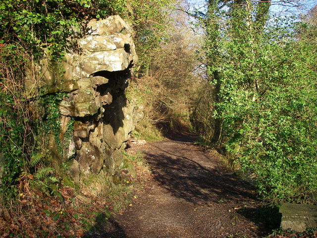
English: Farewell Rock A popular path starts up beside the Nedd Fechan from behind the Angel Inn. It was originally cut into the sheer sides of the gorge to accommodate a tramway to bring 'silica rock' - a particularly pure sandstone suitable for the manufacture of refractory bricks - down from the various mines further up the valley. However the rock outcrop here is an example of another thick bed of sandstone known as the 'Farewell Rock' which marks the very base of the South Wales Coal Measures. Mining below it was fruitless, as no further ironstone or coal seams would be encountered - 'farewell' to useful mining - hence the colourful name. |
| Date | |
| Source | From geograph.org.uk |
| Author | Alan Bowring |
| Attribution (required by the license) | Alan Bowring / Farewell Rock / |
| Camera location | | View this and other nearby images on: OpenStreetMap |
|---|
_heading:337.00&language=en)
| Object location | | View this and other nearby images on: OpenStreetMap |
|---|
_heading:337.00&language=en)
Licensing
[edit]

|
This image was taken from the Geograph project collection. See this photograph's page on the Geograph website for the photographer's contact details. The copyright on this image is owned by Alan Bowring and is licensed for reuse under the Creative Commons Attribution-ShareAlike 2.0 license.
|
This file is licensed under the Creative Commons Attribution-Share Alike 2.0 Generic license.
Attribution: Alan Bowring
- You are free:
- to share – to copy, distribute and transmit the work
- to remix – to adapt the work
- Under the following conditions:
- attribution – You must give appropriate credit, provide a link to the license, and indicate if changes were made. You may do so in any reasonable manner, but not in any way that suggests the licensor endorses you or your use.
- share alike – If you remix, transform, or build upon the material, you must distribute your contributions under the same or compatible license as the original.
File history
Click on a date/time to view the file as it appeared at that time.
| Date/Time | Thumbnail | Dimensions | User | Comment | |
|---|---|---|---|---|---|
| current | 01:28, 8 February 2011 | | 640 × 480 (172 KB) | GeographBot (talk | contribs) | == {{int:filedesc}} == {{Information |description={{en|1=Farewell Rock A popular path starts up beside the Nedd Fechan from behind the Angel Inn. It was originally cut into the sheer sides of the gorge to accommodate a tramway to bring 'silica rock' - a |
You cannot overwrite this file.
File usage on Commons
There are no pages that use this file.