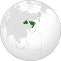
File:Far Eastern Republic (orthographic projection).svg

Original file (SVG file, nominally 536 × 536 pixels, file size: 373 KB)
Captions
Captions
The factual accuracy of this map or the file name is disputed.
Reason: see image notes (non-historic borders) |  |
See File:Far_Eastern_Republic_(orthographic_projection).png for how this image should look.
Summary
[edit]| DescriptionFar Eastern Republic (orthographic projection).svg |
English: An orthographic projection of the Far Eastern Republic, with maximum extension 1920 in both green and extension from 1920 to 1922 in dark green.
Deutsch: Ausdehnung der Fernöstlichen Republik 1920 in Grüntönen und 1920 bis 1922 in Dunkelgrün.
Русский: Орфографическая проекция Дальневосточной республики на её максимальную площадь. |
| Date | |
| Source |
Based off of File:Japan (orthographic projection).svg This W3C-unspecified vector image was created with Inkscape . |
| Author | NuclearVacuum |
| Other versions | File:Far_Eastern_Republic_(orthographic_projection).png |
Licensing
[edit]- You are free:
- to share – to copy, distribute and transmit the work
- to remix – to adapt the work
- Under the following conditions:
- attribution – You must give appropriate credit, provide a link to the license, and indicate if changes were made. You may do so in any reasonable manner, but not in any way that suggests the licensor endorses you or your use.
- share alike – If you remix, transform, or build upon the material, you must distribute your contributions under the same or compatible license as the original.

|
Permission is granted to copy, distribute and/or modify this document under the terms of the GNU Free Documentation License, Version 1.2 or any later version published by the Free Software Foundation; with no Invariant Sections, no Front-Cover Texts, and no Back-Cover Texts. A copy of the license is included in the section entitled GNU Free Documentation License.http://www.gnu.org/copyleft/fdl.htmlGFDLGNU Free Documentation Licensetruetrue |
| Annotations InfoField | This image is annotated: View the annotations at Commons |
Mistake : Brunei is under the British rule, as well as East Malaysia. The border should be removed from the map.
Mistake : the border between Eastern Timor (Portugal) and Western Timor (Netherlands) is missing.
Mistake : Burma is under the British rule, as well as the entire India. The border should be removed from the map.
Mistakes : these borders are those of today instead of those of 1920.
File history
Click on a date/time to view the file as it appeared at that time.
| Date/Time | Thumbnail | Dimensions | User | Comment | |
|---|---|---|---|---|---|
| current | 09:53, 16 May 2020 |  | 536 × 536 (373 KB) | Don-kun (talk | contribs) | Reverted to version as of 09:14, 26 July 2011 (UTC), see: "Putzger Historischer Weltatlas", Cornelsen, 2005, S. 158; "Atlas der Weltgeschichte", Bechtermünz Verlag, 1997, S. 120. and "Haack Taschenatlas Weltgeschichte" (Klett Perthes Gotha 2002) |
| 06:43, 16 May 2020 |  | 536 × 536 (373 KB) | Argenciy (talk | contribs) | Correct the borders | |
| 17:07, 23 March 2012 |  | 536 × 536 (373 KB) | NuclearVacuum (talk | contribs) | Reverted to version as of 22:56, 25 July 2011 correct border and coloring | |
| 09:14, 26 July 2011 |  | 536 × 536 (373 KB) | Don-kun (talk | contribs) | Borders were correst, see sources | |
| 22:56, 25 July 2011 |  | 536 × 536 (373 KB) | NuclearVacuum (talk | contribs) | minor fix | |
| 22:54, 25 July 2011 |  | 536 × 536 (373 KB) | NuclearVacuum (talk | contribs) | minor corrections | |
| 22:49, 25 July 2011 |  | 536 × 536 (373 KB) | NuclearVacuum (talk | contribs) | correcting the borders | |
| 12:35, 21 June 2011 |  | 536 × 536 (373 KB) | Don-kun (talk | contribs) | cor Sachalin | |
| 19:15, 19 June 2011 |  | 536 × 536 (375 KB) | Don-kun (talk | contribs) | correction with "Haack Taschenatlas Weltgeschichte" (Klett Perthes Gotha 2002) | |
| 16:36, 2 June 2011 |  | 536 × 536 (360 KB) | Don-kun (talk | contribs) | cor extension, source: "Putzger Historischer Weltatlas", Cornelsen, 2005, S. 158; "Atlas der Weltgeschichte", Bechtermünz Verlag, 1997, S. 120. |
You cannot overwrite this file.
File usage on Commons
The following 4 pages use this file:
File usage on other wikis
The following other wikis use this file:
- Usage on ar.wikipedia.org
- Usage on ast.wikipedia.org
- Usage on azb.wikipedia.org
- Usage on bg.wikipedia.org
- Usage on ca.wikipedia.org
- Usage on cs.wikipedia.org
- Usage on da.wikipedia.org
- Usage on de.wikipedia.org
- Usage on el.wikipedia.org
- Usage on en.wikipedia.org
- Usage on eo.wikipedia.org
- Usage on es.wikipedia.org
- Usage on et.wikipedia.org
- Usage on eu.wikipedia.org
- Usage on fa.wikipedia.org
- Usage on fi.wikipedia.org
- Usage on fr.wikipedia.org
- Usage on he.wikipedia.org
- Usage on hu.wikipedia.org
- Usage on id.wikipedia.org
- Usage on it.wikipedia.org
- Usage on ja.wikipedia.org
- Usage on ka.wikipedia.org
- Usage on ko.wikipedia.org
- Usage on lt.wikipedia.org
- Usage on lv.wikipedia.org
- Usage on mn.wikipedia.org
- Usage on pl.wikipedia.org
- Usage on pt.wikipedia.org
- Usage on ru.wikipedia.org
- Usage on sh.wikipedia.org
- Usage on simple.wikipedia.org
- Usage on sr.wikipedia.org
- Usage on th.wikipedia.org
- Usage on tr.wikipedia.org
- Usage on uk.wikipedia.org
- Usage on ur.wikipedia.org
- Usage on vi.wikipedia.org
- Usage on www.wikidata.org
- Usage on zh.wikipedia.org
Metadata
This file contains additional information such as Exif metadata which may have been added by the digital camera, scanner, or software program used to create or digitize it. If the file has been modified from its original state, some details such as the timestamp may not fully reflect those of the original file. The timestamp is only as accurate as the clock in the camera, and it may be completely wrong.
| Width | 536 |
|---|---|
| Height | 536 |