File:Falkirk, The Steeple - geograph.org.uk - 1540536.jpg
Jump to navigation
Jump to search

Size of this preview: 450 × 600 pixels. Other resolutions: 180 × 240 pixels | 480 × 640 pixels.
Original file (480 × 640 pixels, file size: 150 KB, MIME type: image/jpeg)
Captions
Captions
Add a one-line explanation of what this file represents
Summary
[edit]
| Description |
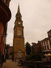
English: Falkirk: The Steeple The Steeple stands alongside the Market Place on the High Street and is the third to occupy the site. The first was a 16th or 7th century structure which was demolished in 1697 having become unsafe. The second suffered from serious subsidence after its foundations became damaged it was demmolished in 1803.
The current structure cost £1,460 to erect in 1814. It was designed by David Hamilton and built by Hanry Taylor using sandstone from the quarry at nearby Brightons. It is 140 feet high and, at ground level, is 22 feet square, and has not been without further difficulties: The upper 40 feet of the tower were replaced after being struck by lightning in June 1927. A horse belonging to Barr & Co., aerated water manufacturers, was killed by the falling masonry and its driver injured. The town jail was once housed within The Steeple, and two cells on the upper floors, accessed by a narrow spiral staircase, survive. |
| Date | |
| Source | From geograph.org.uk |
| Author | Chris Downer |
| Attribution (required by the license) | Chris Downer / Falkirk: The Steeple / |
| Camera location | | View this and other nearby images on: OpenStreetMap |
|---|
_heading:135.00&language=en)
| Object location | | View this and other nearby images on: OpenStreetMap |
|---|
_heading:135.00&language=en)
Licensing
[edit]

|
This image was taken from the Geograph project collection. See this photograph's page on the Geograph website for the photographer's contact details. The copyright on this image is owned by Chris Downer and is licensed for reuse under the Creative Commons Attribution-ShareAlike 2.0 license.
|
This file is licensed under the Creative Commons Attribution-Share Alike 2.0 Generic license.
Attribution: Chris Downer
- You are free:
- to share – to copy, distribute and transmit the work
- to remix – to adapt the work
- Under the following conditions:
- attribution – You must give appropriate credit, provide a link to the license, and indicate if changes were made. You may do so in any reasonable manner, but not in any way that suggests the licensor endorses you or your use.
- share alike – If you remix, transform, or build upon the material, you must distribute your contributions under the same or compatible license as the original.
File history
Click on a date/time to view the file as it appeared at that time.
| Date/Time | Thumbnail | Dimensions | User | Comment | |
|---|---|---|---|---|---|
| current | 09:38, 3 March 2011 | | 480 × 640 (150 KB) | GeographBot (talk | contribs) | == {{int:filedesc}} == {{Information |description={{en|1=Falkirk: The Steeple The Steeple stands alongside the Market Place on the High Street and is the third to occupy the site. The first was a 16th or 7th century structure which was demolished in 1697 |
You cannot overwrite this file.
File usage on Commons
There are no pages that use this file.
File usage on other wikis
The following other wikis use this file:
- Usage on de.wikipedia.org
- Usage on eu.wikipedia.org