File:Falk Oberdorf Eggetal Karte (politisch).jpg
Jump to navigation
Jump to search
Size of this preview: 747 × 600 pixels. Other resolutions: 299 × 240 pixels | 598 × 480 pixels | 957 × 768 pixels | 1,025 × 823 pixels.
Original file (1,025 × 823 pixels, file size: 167 KB, MIME type: image/jpeg)
Captions
Captions
Add a one-line explanation of what this file represents
Summary
[edit]
|
This map image could be re-created using vector graphics as an SVG file. This has several advantages; see Commons:Media for cleanup for more information. If an SVG form of this image is available, please upload it and afterwards replace this template with
{{vector version available|new image name}}.
It is recommended to name the SVG file “Falk Oberdorf Eggetal Karte (politisch).svg”—then the template Vector version available (or Vva) does not need the new image name parameter. |


| Description |
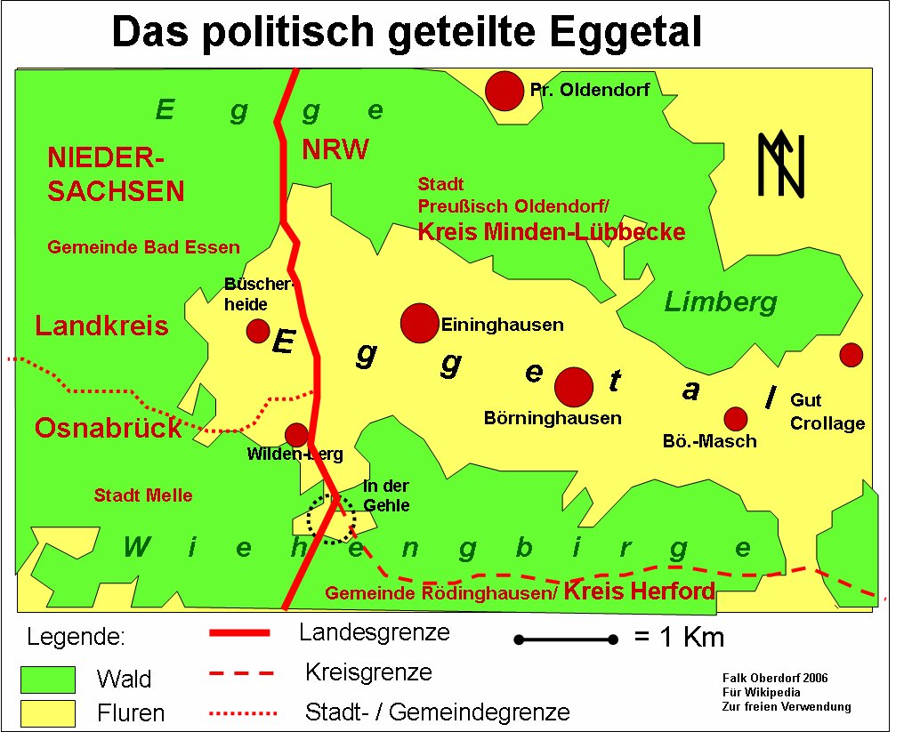
Deutsch: Karte des Eggetals in Nordrhein-Westfalen und Niedersachsen. |
| Date | |
| Source | Own work (Original text: Selbst erstellt) |
| Author | FalkOberdorf at German Wikipedia |
| Other versions |
|

.jpg&action=edit§ion=1)
| Object location | | View this and other nearby images on: OpenStreetMap |
|---|
.jpg¶ms=052.275089_N_0008.485564_E_globe:Earth_class:object_type:object__&language=en)
Licensing
[edit].jpg&action=edit§ion=2)
FalkOberdorf at the German-language Wikipedia, the copyright holder of this work, hereby publishes it under the following license:

|
Permission is granted to copy, distribute and/or modify this document under the terms of the GNU Free Documentation License, Version 1.2 or any later version published by the Free Software Foundation; with no Invariant Sections, no Front-Cover Texts, and no Back-Cover Texts. A copy of the license is included in the section entitled GNU Free Documentation License. |
| This file is licensed under the Creative Commons Attribution-Share Alike 3.0 Unported license. | ||
| Attribution: FalkOberdorf | ||
| ||
| This licensing tag was added to this file as part of the GFDL licensing update. |
Original upload log
[edit].jpg&action=edit§ion=3)
The original description page was here. All following user names refer to de.wikipedia.
- 2006-06-15 13:45 FalkOberdorf 1025×823× (171164 bytes) * Bildbeschreibung: Karte des Eggetals * Quelle: selbst erstellt * Fotograf/Zeichner: Falk Oberdorf, Osterstr. 8~~~ * Datum: 15.06.2006 * Sonstiges: ...
File history
Click on a date/time to view the file as it appeared at that time.
| Date/Time | Thumbnail | Dimensions | User | Comment | |
|---|---|---|---|---|---|
| current | 15:34, 18 December 2008 | | 1,025 × 823 (167 KB) | TUBS (talk | contribs) | {{Information |Description={{de|Karte des Eggetals * Sonstiges: ...}} |Source=Transferred from [http://de.wikipedia.org de.wikipedia]<br/> (Original text : ''Selbst erstellt'') |Date=15.06.2006<br/> 2006-06-15 (original upload date) |Author=Original uploa |
You cannot overwrite this file.
File usage on Commons
The following 3 pages use this file:
File usage on other wikis
The following other wikis use this file:
- Usage on de.wikipedia.org
- Usage on ja.wikipedia.org
- Usage on www.wikidata.org
.jpg&oldid=577969013)