File:FalkOberdorf Karte Borninghausen.JPG
Jump to navigation
Jump to search
No higher resolution available.
FalkOberdorf_Karte_Borninghausen.JPG (738 × 592 pixels, file size: 81 KB, MIME type: image/jpeg)
Captions
Captions
Add a one-line explanation of what this file represents
Summary
[edit]| Description |
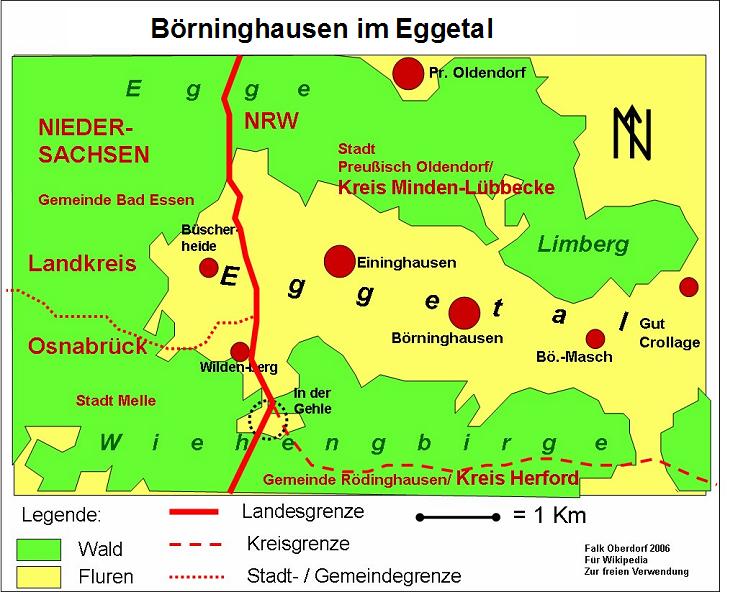
Deutsch: Karte des Eggetals im Wiehengbebirge und Lage des Ortes Börninghausen (Ortsteil von Preußisch Oldendorf, Kreis Minden-Lübbecke, Nordrhein-Westfalen) im Eggetal. |
| Date |
1 January 2008 (original upload date) |
| Source | Own work (Original text: selbst erstellt) |
| Author | Falk Oberdorf, Osterstr. 8, 32312 Lübbecke |
| Other versions |
|
.jpg)
| Object location | | View this and other nearby images on: OpenStreetMap |
|---|
Licensing
[edit]
FalkOberdorf at the German-language Wikipedia, the copyright holder of this work, hereby publishes it under the following license:

|
Permission is granted to copy, distribute and/or modify this document under the terms of the GNU Free Documentation License, Version 1.2 or any later version published by the Free Software Foundation; with no Invariant Sections, no Front-Cover Texts, and no Back-Cover Texts. A copy of the license is included in the section entitled GNU Free Documentation License. |
| This file is licensed under the Creative Commons Attribution-Share Alike 3.0 Unported license. | ||
| Attribution: FalkOberdorf | ||
| ||
| This licensing tag was added to this file as part of the GFDL licensing update. |
Original upload log
[edit]
Transferred from de.wikipedia to Commons by TUBS using CommonsHelper.
The original description page was here. All following user names refer to de.wikipedia.
- 2008-01-01 14:19 FalkOberdorf 738×592× (82568 bytes) {{Information |Beschreibung = Karte des Eggetals |Quelle = selbst erstellt |Urheber = Falk Oberdorf, Osterstr. 8, 32312 Lübbecke |Datum = 01.01.2008 |Genehmigung = |Andere Versionen = |Anmerkungen = }}
File history
Click on a date/time to view the file as it appeared at that time.
| Date/Time | Thumbnail | Dimensions | User | Comment | |
|---|---|---|---|---|---|
| current | 11:45, 4 January 2009 | | 738 × 592 (81 KB) | File Upload Bot (Magnus Manske) (talk | contribs) | {{BotMoveToCommons|de.wikipedia}} {{Information |Description={{de|Karte des Eggetals}} |Source=Transferred from [http://de.wikipedia.org de.wikipedia]; transferred to Commons by User:TUBS using [http://tools.wikimedia.de/~magnus/commonshelper.php Com |
You cannot overwrite this file.
File usage on Commons
The following page uses this file:
File usage on other wikis
The following other wikis use this file:
- Usage on de.wikipedia.org