File:Fairford Station - geograph.org.uk - 2035726.jpg
Jump to navigation
Jump to search
No higher resolution available.
Fairford_Station_-_geograph.org.uk_-_2035726.jpg (640 × 385 pixels, file size: 144 KB, MIME type: image/jpeg)
Captions
Captions
Add a one-line explanation of what this file represents
Summary
[edit]
| Description |
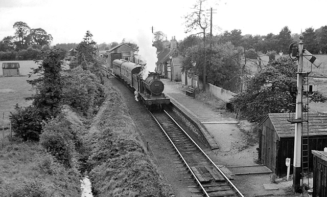
English: Fairford Station, View westward, towards buffer-stops; ex-Great Western terminus of branch from Oxford via Witney, which closed completely on 18/6/62. (In fact the line continued for a few hundred yards further, as it had been intended to go to Cirencester). The train is about to leave for Oxford, hauled by a 22XX class 0-6-0. |
| Date | |
| Source | From geograph.org.uk; transferred by User:Edward using geograph_org2commons. |
| Author | Ben Brooksbank |
| Permission (Reusing this file) |
Creative Commons Attribution Share-alike license 2.0 |
| Attribution (required by the license) | Ben Brooksbank / Fairford Station / |
| Camera location | | View this and other nearby images on: OpenStreetMap |
|---|
| Object location | | View this and other nearby images on: OpenStreetMap |
|---|
_region:GB-GBN_heading:270.00&language=en)
Licensing
[edit]

|
This image was taken from the Geograph project collection. See this photograph's page on the Geograph website for the photographer's contact details. The copyright on this image is owned by Ben Brooksbank and is licensed for reuse under the Creative Commons Attribution-ShareAlike 2.0 license.
|
This file is licensed under the Creative Commons Attribution-Share Alike 2.0 Generic license.
Attribution: Ben Brooksbank
- You are free:
- to share – to copy, distribute and transmit the work
- to remix – to adapt the work
- Under the following conditions:
- attribution – You must give appropriate credit, provide a link to the license, and indicate if changes were made. You may do so in any reasonable manner, but not in any way that suggests the licensor endorses you or your use.
- share alike – If you remix, transform, or build upon the material, you must distribute your contributions under the same or compatible license as the original.
File history
Click on a date/time to view the file as it appeared at that time.
| Date/Time | Thumbnail | Dimensions | User | Comment | |
|---|---|---|---|---|---|
| current | 16:37, 31 August 2010 | | 640 × 385 (144 KB) | File Upload Bot (Magnus Manske) (talk | contribs) | == {{int:filedesc}} == {{Information |Description={{en|1=Fairford Station, near to Horcott, Gloucestershire, Great Britain. View westward, towards buffer-stops; ex-Great Western terminus of branch from Oxford via Witney, which closed completely on 18/6/62 |
You cannot overwrite this file.
File usage on Commons
The following page uses this file:
File usage on other wikis
The following other wikis use this file:
- Usage on en.wikipedia.org
- Usage on www.wikidata.org