File:Fairfield Township panorama.jpg
Jump to navigation
Jump to search

Size of this preview: 798 × 128 pixels. Other resolutions: 320 × 51 pixels | 640 × 103 pixels | 1,024 × 164 pixels | 1,280 × 205 pixels | 8,496 × 1,363 pixels.
Original file (8,496 × 1,363 pixels, file size: 1.33 MB, MIME type: image/jpeg)
Captions
Captions
Add a one-line explanation of what this file represents
Summary
[edit]
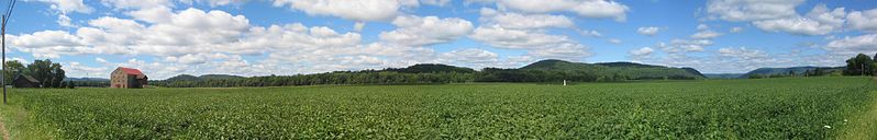
| Description | Panorama of the Loyalsock Creek valley in Fairfield Township, Lycoming County, Pennsylvania, United States. Taken from Pennsylvania Route 87, left hand side is south (Bald Eagle Mountain visible), old barn, early cemetery in middle of field, and right is north with the opening of the Loyalsock Creek valley visible. |
| Date | |
| Source |
Photographed it myself, This panoramic image was created with Autostitch (stitched images may differ from reality). |
| Author | User:Ruhrfisch |
| Permission (Reusing this file) |
GFDL. I, Ruhrfisch, give permission for Coalition for Responsible Growth & Resource Conservation to use this photo. |
Licensing
[edit]

|
Permission is granted to copy, distribute and/or modify this document under the terms of the GNU Free Documentation License, Version 1.2 or any later version published by the Free Software Foundation; with no Invariant Sections, no Front-Cover Texts, and no Back-Cover Texts. A copy of the license is included in the section entitled GNU Free Documentation License. |
| This file is licensed under the Creative Commons Attribution-Share Alike 3.0 Unported license. | ||
| ||
| This licensing tag was added to this file as part of the GFDL licensing update. |
File history
Click on a date/time to view the file as it appeared at that time.
| Date/Time | Thumbnail | Dimensions | User | Comment | |
|---|---|---|---|---|---|
| current | 18:22, 14 September 2007 | 8,496 × 1,363 (1.33 MB) | Ruhrfisch (talk | contribs) | == Summary == {{Information |Description= Panorama of the Loyalsock Creek valley in Fairfield Township, Lycoming County, Pennsylvania, United States. Taken from Pennsylvania Route 87, left hand side is south (Bald Eagle Mountain visible), old barn, early |
You cannot overwrite this file.
File usage on Commons
The following page uses this file:
File usage on other wikis
The following other wikis use this file:
- Usage on en.wikipedia.org