File:FI Lighthouse pan.jpg
Jump to navigation
Jump to search

Size of this preview: 800 × 125 pixels. Other resolutions: 320 × 50 pixels | 640 × 100 pixels | 1,024 × 159 pixels | 1,280 × 199 pixels | 11,475 × 1,787 pixels.
Original file (11,475 × 1,787 pixels, file size: 4.25 MB, MIME type: image/jpeg)
Captions
Captions
Add a one-line explanation of what this file represents
Summary
[edit]
40°37′42″N 73°13′32″W / 40.628252°N 73.225529°W
| Description |
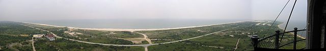
English: Panorama of Fire Island from Fire Island Lighthouse |
| Date | August 2008 (6 August 2008, according to Exif data) |
| Source | Own work |
| Author | ThreeOneFive at English Wikipedia |
Licensing
[edit]
| This work has been released into the public domain by its author, ThreeOneFive at English Wikipedia. This applies worldwide. In some countries this may not be legally possible; if so: ThreeOneFive grants anyone the right to use this work for any purpose, without any conditions, unless such conditions are required by law. |
Original upload log
[edit]
The original description page was here. All following user names refer to en.wikipedia.
- 2008-08-13 11:56 ThreeOneFive 11475×1787× (4459635 bytes) {{Information |Description=Fire Island Lighthouse |Source=I created this work entirely by myself. |Date=August 2008 |Author=~~~ |other_versions= }}
File history
Click on a date/time to view the file as it appeared at that time.
| Date/Time | Thumbnail | Dimensions | User | Comment | |
|---|---|---|---|---|---|
| current | 17:59, 21 May 2011 | 11,475 × 1,787 (4.25 MB) | K3vin (talk | contribs) |
You cannot overwrite this file.
File usage on Commons
There are no pages that use this file.
File usage on other wikis
The following other wikis use this file:
- Usage on en.wikipedia.org
- Usage on en.wikiquote.org
- Usage on fa.wikipedia.org
- Usage on ja.wikipedia.org
- Usage on pt.wikipedia.org