File:FI-18 - Helsinki - 2009-07-19 (4891342715).jpg
Jump to navigation
Jump to search

Size of this preview: 800 × 517 pixels. Other resolutions: 320 × 207 pixels | 640 × 413 pixels | 1,024 × 661 pixels | 1,280 × 827 pixels | 2,560 × 1,654 pixels | 4,208 × 2,718 pixels.
Original file (4,208 × 2,718 pixels, file size: 8.5 MB, MIME type: image/jpeg)
Captions
Captions
Add a one-line explanation of what this file represents
Summary
[edit]| Description |
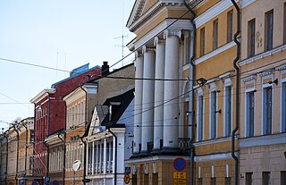
English: Aleksanterinkatu, Helsinki, Finland. Buildings seen in the image from right to left: First block: Burtz (a tiny part of it, light brown, completed in 1770) and Bock (yellow with 4 white columns, 1763). Next block: Sederholm (grey, 1757), Remander (yellow, 1814), Brummer (low, dark red, 1823) and Balder (red, 1814). Last block: the offices of Ministry of employment and economy in Aleksanterinkatu 4-10: Cadenius building (1820s?, designed 1817), Weckman building (white pilasters, 1810s, designed 1813-), Sederholm's another building (1810s) and last a tiny shread of Borgström house (1826).
Suomi: Aleksanterinkatu, Helsinki, Suomi. Kuvassa näkyvät rakennukset oikealta vasemmalle: ensimmäinen kortteli (Leijona): Burtzin talo (pieni osa, vaaleanruskea, valmistunut 1770) ja Bockin talo (keltainen, 4 valkoista pilaria, 1763). Seuraavassa ( Elefantin) korttelissa: Sederholmin talo (harmaa, 1757), Remanderin talo (keltainen, 1814), Brummerin talo (matala, tumma punainen, 1823) ja Balderin talo (punainen, 1814). Viimeinen kortteli (Leopardi): työ- ja elinkeinoministeriön toimitilat, Aleksanterinkatu 4-10: Cadeniuksen talo (1820-luvulla, suunnittelu aloitettu 1817), Weckmanin talo (valkoiset pilasterit, 1810-luvulla, alettu suunnitella 1813), kauppias Sederholmin rakennuttama toinen rakennus (1810-luvulla) ja viimeisenä näkyy kapea kaistale Borgströmin taloa (1826).
| ||
| Address |
|
||
| Date | |||
| Source | 2009-07-19T10-57-22 -- DSC_0518 | ||
| Author | CGP Grey | ||
| Other versions |
|
.jpg)
.jpg&action=edit§ion=1)
| Camera location | | View this and other nearby images on: OpenStreetMap |
|---|
.jpg¶ms=060.169333_N_0024.952833_E_globe:Earth_type:camera_region:FI-18_alt:12.8_source:exif_&language=en)
Licensing
[edit].jpg&action=edit§ion=2)
This file is licensed under the Creative Commons Attribution 2.0 Generic license.
Attribution: http://www.cgpgrey.com
- You are free:
- to share – to copy, distribute and transmit the work
- to remix – to adapt the work
- Under the following conditions:
- attribution – You must give appropriate credit, provide a link to the license, and indicate if changes were made. You may do so in any reasonable manner, but not in any way that suggests the licensor endorses you or your use.
| This image, originally posted to Flickr, was reviewed on 12 December 2014 by the administrator or reviewer RP88, who confirmed that it was available on Flickr under the stated license on that date. |
File history
Click on a date/time to view the file as it appeared at that time.
| Date/Time | Thumbnail | Dimensions | User | Comment | |
|---|---|---|---|---|---|
| current | 17:46, 12 December 2014 | | 4,208 × 2,718 (8.5 MB) | 1Veertje (talk | contribs) | {{rename|FI-18 - Helsinki - 2009-07-19 (4891342715).jpg|2}} =={{int:filedesc}}== {{Information | Description = {{Building address | Street name = | House number = | House name = | Postal code = | City =Helsinki | State = 18 | Country = FI | |
You cannot overwrite this file.
File usage on Commons
The following 2 pages use this file:
.jpg&oldid=875062497)