File:FEMA 403 NYC Cooperative Building Damage Assessment Map of November 7, 2001.png
Jump to navigation
Jump to search

Size of this preview: 464 × 599 pixels. Other resolutions: 186 × 240 pixels | 372 × 480 pixels | 595 × 768 pixels | 793 × 1,024 pixels | 1,363 × 1,759 pixels.
Original file (1,363 × 1,759 pixels, file size: 310 KB, MIME type: image/png)
Captions
Captions
Add a one-line explanation of what this file represents
Summary
[edit]
| Description |
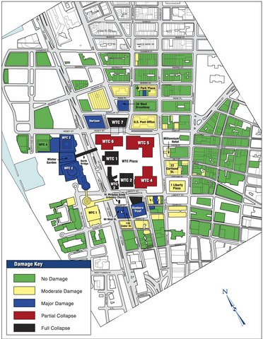
English: New York City DDC/DoB Cooperative Building Damage Assessment Map of November 7, 2001 (based on SEAoNY inspections
of September and October 2001) |
| Date | |
| Source | FEMA 403 - World Trade Center Building Performance Study, Chapter 7. Peripheral Buildings |
| Author | FEMA |
Licensing
[edit]
This image is a work of a Federal Emergency Management Agency employee, taken or made as part of that person's official duties. As works of the U.S. federal government, all FEMA images are in the public domain in the United States. Additional media usage information may be found at https://www.fema.gov/photo-video-audio-use-guidelines
|
File history
Click on a date/time to view the file as it appeared at that time.
| Date/Time | Thumbnail | Dimensions | User | Comment | |
|---|---|---|---|---|---|
| current | 04:25, 3 September 2022 | | 1,363 × 1,759 (310 KB) | YitzhakNat (talk | contribs) | res |
| 00:59, 27 November 2012 |  | 982 × 1,274 (1.17 MB) | ArtifexMayhem (talk | contribs) | User created page with UploadWizard |
You cannot overwrite this file.
File usage on Commons
The following page uses this file:
File usage on other wikis
The following other wikis use this file:
- Usage on en.wikipedia.org
- Usage on nl.wikipedia.org