File:Eyalet Algeria in 1560.png
Jump to navigation
Jump to search

Size of this preview: 800 × 552 pixels. Other resolutions: 320 × 221 pixels | 640 × 442 pixels | 1,024 × 707 pixels | 1,280 × 884 pixels | 2,068 × 1,428 pixels.
Original file (2,068 × 1,428 pixels, file size: 1.53 MB, MIME type: image/png)
Captions
Captions
Eyalet Algeria in 1560
Summary
[edit]
| Description |
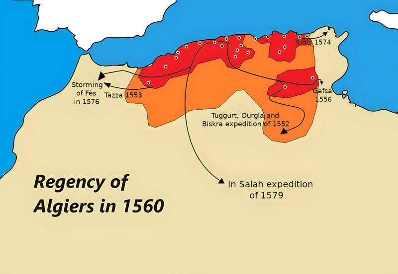
Français : Légendes:
  • En Orange Foncé: Elayet d’Algérie
  • En Orange: Régions vassales ou sous influence de l’Elayet d’Algérie
  • Cercle noir: Forts et Garnisons algériennes permanentes
Sources et Bibliographie : • Charles Féraud, Histoire des sultans de Touggourt et du Sud Algérien, 2006, 162 • Histoire de l'Afrique septentrionale, Ernest MERCIER • Carte des Régences d’Alger et de Tunis selon Dr. Shaw • Voyage dans la Régence d’Alger, Dr. Shaw • Fondation de la Régence d’Alger, traduction du livre «غزوات عروج وخير الدين » par Sander Rang et Ferdinand Denis • Historical Atlas of Islamic Word, Malise Ruthven and Azim Nanji • African History in Maps, Michael_Kwamena-Poh, John_Tosh and Richard Waller • History of the World Map, Peter Snow • Atlas of Islamic, Peter Sluglett and Andrew Currie • Philip's atlas of world history, Patrick O'Brien • Work of Kayra Atakan [Qirim Xan’i] and his video « Türk Tarihi---History of Turks » (https://www.youtube.com/watch?v=BwQINDPHbFk) • Tachirifat de l’Eyalet • Les Collections de l’Histoire, n°45 et n°63; divers cartes du site euratlas.net • Atlas de l’Afrique, Le Jaguar 2009 • Atlas historique: L'histoire du monde, Duby George • Revue Africaine • Recherche sur l’Algérie à l’époque ottomane, Lemnouar Menouche • Gens et choses de Colomb-Béchar (Sud Oranais) par L. Céard • Wikipédia, Wikimédia common...et sites affiliée • L’Histoire et le site lhistoire.fr et la carte https://www.lhistoire.fr/portfolio/carte-lempire-ottoman-xvie-xviiie-si%C3%A8cle English: Legends: • In Dark Orange: Elayet of Algeria • In Orange: Vassal region or under the influence of Elayet of Algeria • Black circle: Permanent Algerian Forts and Garnisons• |
| Date | |
| Source | Own work |
| Author | AtlasDzMapper |
Licensing
[edit]
I, the copyright holder of this work, hereby publish it under the following license:
This file is licensed under the Creative Commons Attribution-Share Alike 3.0 Unported license.
- You are free:
- to share – to copy, distribute and transmit the work
- to remix – to adapt the work
- Under the following conditions:
- attribution – You must give appropriate credit, provide a link to the license, and indicate if changes were made. You may do so in any reasonable manner, but not in any way that suggests the licensor endorses you or your use.
- share alike – If you remix, transform, or build upon the material, you must distribute your contributions under the same or compatible license as the original.
File history
Click on a date/time to view the file as it appeared at that time.
| Date/Time | Thumbnail | Dimensions | User | Comment | |
|---|---|---|---|---|---|
| current | 16:37, 6 October 2023 | | 2,068 × 1,428 (1.53 MB) | Nourerrahmane (talk | contribs) | Better quality |
| 21:18, 8 December 2019 |  | 1,034 × 714 (90 KB) | SouthPyrethre (talk | contribs) | Add Saharien expedition of 1552 | |
| 17:14, 8 December 2019 |  | 1,034 × 714 (81 KB) | SouthPyrethre (talk | contribs) | User created page with UploadWizard |
You cannot overwrite this file.
File usage on Commons
There are no pages that use this file.
File usage on other wikis
The following other wikis use this file:
- Usage on ar.wikipedia.org
- Usage on az.wikipedia.org
- Usage on cs.wikipedia.org
- Usage on en.wikipedia.org
- Usage on fa.wikipedia.org
- Usage on fr.wikipedia.org
- Usage on nl.wikipedia.org
- Usage on ru.wikipedia.org
- Usage on tr.wikipedia.org