File:Extrait d'une carte de Saint Malo montrant Cézambre à marée basse (16e ou 17e siècle).jpg
Jump to navigation
Jump to search

Size of this preview: 800 × 386 pixels. Other resolutions: 320 × 154 pixels | 640 × 309 pixels | 1,024 × 494 pixels | 1,280 × 618 pixels | 3,128 × 1,510 pixels.
Original file (3,128 × 1,510 pixels, file size: 590 KB, MIME type: image/jpeg)
Captions
Captions
Add a one-line explanation of what this file represents
Summary
[edit].jpg&action=edit§ion=1)
| Description |
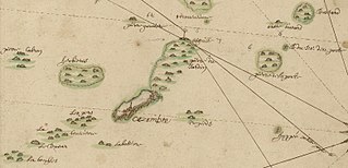
Français : Extrait d'une carte de Saint Malo (orientée sud), "Carte du port de Saint Malo comme il parroist dans la plus basse mer". On remarque la présence d'une chapelle sur l'île. La date de création de cette carte est inconnue (autour du 16e ou 17e siècle)
English: Extract of a map of Saint Malo showing the island of Cézembre and the surrounding islets. A chapel is drawn on the island. Date of creation of the map is unknown (around 16th or 17th century) |
| Date | circa 1600-1700 |
| Source | http://gallica.bnf.fr/ark:/12148/btv1b530168749/f1.item.r=Carte%20Saint%20Malo.zoom |
| Author | Unknown author |
Licensing
[edit].jpg&action=edit§ion=2)
|
This work is in the public domain in its country of origin and other countries and areas where the copyright term is the author's life plus 70 years or fewer. This work is in the public domain in the United States because it was published (or registered with the U.S. Copyright Office) before January 1, 1929. | |
| This file has been identified as being free of known restrictions under copyright law, including all related and neighboring rights. | |
File history
Click on a date/time to view the file as it appeared at that time.
| Date/Time | Thumbnail | Dimensions | User | Comment | |
|---|---|---|---|---|---|
| current | 14:43, 11 May 2018 | | 3,128 × 1,510 (590 KB) | Skimel (talk | contribs) | User created page with UploadWizard |
You cannot overwrite this file.
File usage on Commons
There are no pages that use this file.
File usage on other wikis
The following other wikis use this file:
- Usage on fr.wikipedia.org
.jpg&oldid=804409334)