File:Extract map Levasseur 1852.jpg

Original file (819 × 498 pixels, file size: 87 KB, MIME type: image/jpeg)
Captions
Captions
Summary
[edit]
| Author |
|
|||||||||||||||||||
| Description |
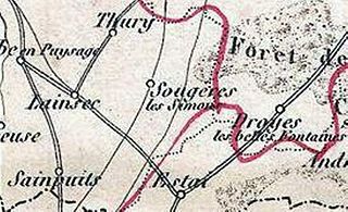
English: This is a fascinating 1852 map of the French department of L'Yonne, France. L'Yonne is of France's premier Burgundy wine region and produces some of the worlds finest reds. Yonne is also one of only two departments that produce Chaource cheese. Chaource is a cow's milk cheese, cylindrical in shape. The central pâte is soft, creamy in color, and slightly crumbly, and is surrounded by a white penicillium candidum rind. The whole map is surrounded by elaborate decorative engravings designed to illustrate both the natural beauty and trade richness of the land. There is a short textual history of the regions depicted on both the left and right sides of the map. Published by V. Levasseur in the 1852 edition of his Atlas National de la France Illustree. |
|||||||||||||||||||
| Date | 23 April 2012, 21:29 (UTC) | |||||||||||||||||||
| Dimensions | height: 11.5 in (29.2 cm); width: 16.5 in (41.9 cm) | |||||||||||||||||||
| Accession number |
Geographicus link: LYonne-levasseur-1852 |
|||||||||||||||||||
| Source/Photographer |
This file was derived from: 1852 Levasseur Map of the Department De L'Yonne (Burgundy or Bourgogne Wine Region) - Geographicus - LYonne-levasseur-1852.jpg: |
|||||||||||||||||||
_-_Geographicus_-_LYonne-levasseur-1852.jpg)
| This is a retouched picture, which means that it has been digitally altered from its original version. The original can be viewed here: 1852 Levasseur Map of the Department De L'Yonne (Burgundy or Bourgogne Wine Region) - Geographicus - LYonne-levasseur-1852.jpg:
|
Licensing
[edit]
|
This is a faithful photographic reproduction of a two-dimensional, public domain work of art. The work of art itself is in the public domain for the following reason:
The official position taken by the Wikimedia Foundation is that "faithful reproductions of two-dimensional public domain works of art are public domain".
This photographic reproduction is therefore also considered to be in the public domain in the United States. In other jurisdictions, re-use of this content may be restricted; see Reuse of PD-Art photographs for details. | ||||
Original upload log
[edit]
This image is a derivative work of the following images:
- File:1852_Levasseur_Map_of_the_Department_De_L'Yonne_(Burgundy_or_Bourgogne_Wine_Region)_-_Geographicus_-_LYonne-levasseur-1852.jpg licensed with PD-Art, PD-old
- 2011-03-24T06:12:46Z BotMultichillT 3500x2532 (3240170 Bytes) {{subst:User:Multichill/Geographicus |link=http://www.geographicus.com/P/AntiqueMap/LYonne-levasseur-1852 |product_name=1852 Levasseur Map of the Department De L'Yonne (Burgundy or Bourgogne Wine Region) |map_title=Dept. de l
Uploaded with derivativeFX
File history
Click on a date/time to view the file as it appeared at that time.
| Date/Time | Thumbnail | Dimensions | User | Comment | |
|---|---|---|---|---|---|
| current | 21:31, 23 April 2012 | | 819 × 498 (87 KB) | Benoît Prieur (talk | contribs) | == {{int:filedesc}} == {{Information |Description={{en|This is a fascinating 1852 map of the French department of L'Yonne, France. L'Yonne is of France's premier Burgundy wine region and produces some of the worlds finest reds. Yonne is also one of o... |
You cannot overwrite this file.
File usage on Commons
The following page uses this file:
File usage on other wikis
The following other wikis use this file:
- Usage on fr.wikipedia.org