File:Extension of Germany (1935-1939)-es.svg
Jump to navigation
Jump to search

Size of this PNG preview of this SVG file: 659 × 600 pixels. Other resolutions: 264 × 240 pixels | 527 × 480 pixels | 844 × 768 pixels | 1,125 × 1,024 pixels | 2,250 × 2,048 pixels | 790 × 719 pixels.
Original file (SVG file, nominally 790 × 719 pixels, file size: 648 KB)
Captions
Captions
Add a one-line explanation of what this file represents
| Description |
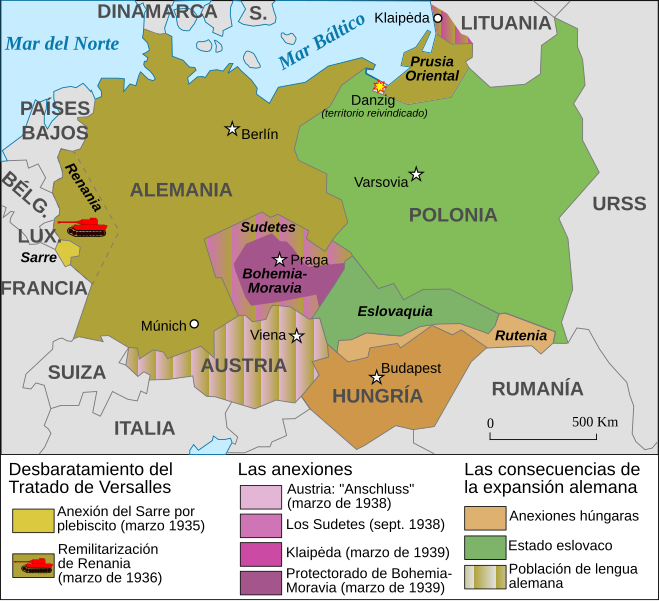
Español: Mapa de la extensión de Alemania (1935-1939) |
||||||||
| Date | |||||||||
| Source | Based on Image:Extension of Germany (1935-1939)-fr.svg | ||||||||
| Author | JMPerez | ||||||||
| Permission (Reusing this file) |
I, the copyright holder of this work, hereby publish it under the following licenses:
This file is licensed under the Creative Commons Attribution-Share Alike 2.5 Generic, 2.0 Generic and 1.0 Generic license.
You may select the license of your choice. |
||||||||
| Other versions |
Français : Carte en français Image:Extension of Germany (1935-1939)-fr.svg English: French version Image:Extension of Germany (1935-1939)-fr.svg |

-fr.svg)
-es.svg)
|
This SVG file contains embedded text that can be translated into your language, using any capable SVG editor, text editor or the SVG Translate tool. For more information see: About translating SVG files. |
-es.svg)
File history
Click on a date/time to view the file as it appeared at that time.
| Date/Time | Thumbnail | Dimensions | User | Comment | |
|---|---|---|---|---|---|
| current | 20:01, 14 February 2017 | | 790 × 719 (648 KB) | Rowanwindwhistler (talk | contribs) | https://en.wikipedia.org/wiki/Wikipedia:WikiProject_Maps/Conventions Fake text added Múnich |
| 16:11, 5 September 2007 |  | 741 × 674 (116 KB) | Redtony (talk | contribs) | "Prusia Oriental" traducido | |
| 16:38, 18 August 2007 |  | 741 × 674 (116 KB) | JMPerez~commonswiki (talk | contribs) | {{Information |Description={{es}}Mapa de la extensión de Alemania (1935-1939) |Source=Based on Image:Extension of Germany (1935-1939)-fr.svg |Date=18/08/2007 |Author=JMPerez |Permission={{self2|GFDL|cc-by-sa-2.5,2.0,1.0}} |other_ver |
You cannot overwrite this file.
File usage on Commons
The following page uses this file:
File usage on other wikis
The following other wikis use this file:
- Usage on ast.wikipedia.org
- Usage on ca.wikipedia.org
- Usage on es.wikipedia.org
- Usage on gl.wikipedia.org
-es.svg&oldid=606479281)