File:Extension at the rear of 372 High Road N17.jpg
Original file (1,600 × 1,200 pixels, file size: 658 KB, MIME type: image/jpeg)
Captions
Captions
Summary
[edit]
| Description |
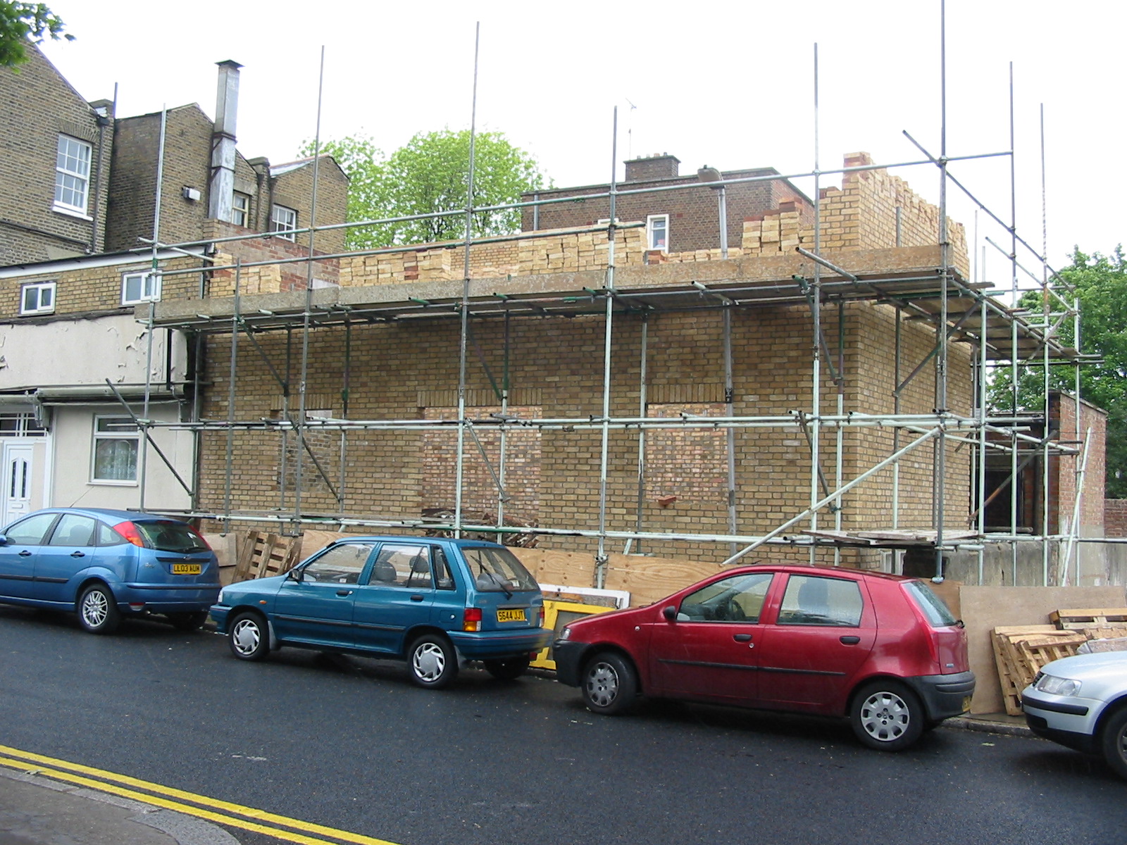
English: 19 May 2005. Photo from Somerset Road N17.
____________________________________________________ WHAT'S THIS ABOUT? Please start here . . . . . . and then continue below. (The quotations in bold are from my previous email on 12 July 2010.) Original Message ----- From : Haringey Urban Environment Department To : Alan Stanton, Tottenham Hale ward Sent : Thursday, September 9, 2010 12:21 PM Subject : LBH/80553 Planning decision - rear of 372 High Road N17 I refer to your email of 12 July and apologise for the delay in replying. The extensions to 372 are essentially in four elements: ● The nearest ground floor extension ● The nearest first floor extension ● The farthest ground floor extension ● The farthest first floor extensions. In the past it was always considered that the nearest ground floor addition was established or even an original part of the building. However later plans submitted during the latest planning appeal seem to support the view that the whole ground floor additional is unauthorised. This argument was accepted by the Court which in part led to the defendants acquittal. (1) "Following my bringing this unauthorised development to the attention of Haringey Planning Service in October 2005, retrospective planning permission was refused." This is correct and an Enforcement Case was opened when you reported this matter on 28th October 2005. Retrospective planning application HGY/2005/2009, received on 26 November 2005. This was refused on 20th December 2005. An appeal against the decision was dismissed by letter on 11th December 2006. Another planning application to retain the development (part 1st floor and two storey rear extension) was also refused and was not appealed on 15th May 2006. As stated previously an Enforcement Notice was served on the two storey rear extension in 2006. This related to the rearmost part of the two storey extension not the part closest to the frontage of Tottenham High Road. (2) "Haringey Planning Service defended Appeal and the Council won the case, appeal dismissed on 11/12/06"! Please see above. (3) "Having won, Haringey went to Court to enforce, but messed-up the case so badly that we lost." On 30th October 2007 prosecution for non-compliance with the Enforcement Notice was heard in the Magistrate Court today. It was adjourned and the owner pled not guilty. On 19th March 2008 he defendant was acquitted - Magistrates found in favour of the defendant as it was not certain that the entire two storey extension was unauthorised given that a 1991 permission for a ground floor extension and restaurant existed and the Court was satisfied that the ground floor element was immune from enforcement action. There was then a need to serve a fresh Enforcement Notice. However the Court decision severely limited what action could be taken. "(4) Haringey Planning then issued a Certificate of Lawfulness on part of the same building.". This was granted on 16th October 2007 under HGY/2007/1671 relates to the first floor nearest the original built on what was thought to be an original ground floor addition. Evidence form Council’s Building Control Service indicates that this work was commenced in 1995 Sworn affidavits from the owner and neighbours atest to the 1st floor being in situ from at least 2000. This was not covered by the Enforcement Notice and therefore not affected by it. (5) "As far as I can tell, despite my being a ward councillor and having taken a specific interest in these premises, I was not told about (3) and (4)" I apologise on behalf of Planning Enforcement for not notifying you in relation to the matters raised in your note (3) above. In relation to your note (4) in relation to the certificate of lawfulness at the time the application was considered you will recall that the Planning Service did not consult in relation to this time of application as it was considered that the applications were dealt with on the basis of evidence and not on judgements of planning matters. (6) "Haringey Planning Service refused a further application from the owner." This is correct. However this related to the first floor of the extended premises only. It was under Ref HGY/2007/2622 and refused on 5th February 2008 for conservation area reasons and amenity harm to near by occupiers. In the Inspector’s report he as of the opinion that the information suggested that the entire ground floor was established being built around about 1991. With this being so and a CoL granted for the nearest first floor extension only the farthest first floor element was enforceable. (7) "Haringey Enforcement Service then decided to take no action." The key difficulty therefore with enforcement after the Court decision was that only the 1st floor of the rearmost extension could have been enforced in terms of operational development and required to be removed. Although it does appear that both the ground and rear floors could be enforced in terms of the change of use to residential, the removal of just the first floor through compliance would be in my opinion a poorer quality building than what is existing. Another factor is that 372-376 High Road have all been substantially extended to the rear and that further enforcement action would not have been proportionate or expedient given the limited outcome of what could have been achieved through compliance. With these limiting factors it was with some regret that the case was considered for closure in 2008. In summation had all facts been known at the outset of your complaint we may have been able to have undertaken more efficient enforcement action and drafted out notices accordingly. The establishment of the entire ground floor as accepted by the Court also significantly lessens the degree of unauthorised development. Certainly our preparation for Court could have been better. The case appears to have suffered from a lack of continuity which has hampered effective enforcement action. In the last two years measures have been put in place to ensure that more through investigations improved updating of complainants and better scrutiny with regard to drafting notices and prosecution preparation to minimise the chance of such matters happening again. In addition improved co-ordination of working with Development Management has improved the decision making process in the last two years. (a) "How often do similar sequences of events occur?" I can only think of one other acquittal. This was where there was strong pressure to prosecute against our advice (the matter had been reduced to within permitted development rights and the Court agreed that the defendant had no case to answer. (b) "How often do they occur in: (i) Tottenham and (ii) areas such as Highgate?" With regard to problems arising due to lack of continuity I can think of two cases which like 372 High Road were older cases where delay, change of personnel and lack of continuity prejudiced our ability to effectively regularise matters with through enforcement or through the planning process. One of these occurred in Seven Sisters ward and the other in Bounds Green Ward from case dating from 2003. (c) "Can you please tell me what purpose is served by the Tottenham Conservation Areas?" The purpose, as with all designated Conservation Areas, is to protect and enhance the character and appearance of the physical environment within the area defined by the Conservation Area. Original Message ----- From : Alan Stanton, Tottenham Hale ward councillor To : Niall Bolger, Director of Urban Environment Sent : Thursday, September 09, 2010 3:30 PM Subject : LBH/80553 Planning decision - rear of 372 High Road N17 Today I received a reply to my Member Enquiry sent on 12 July 2010. Can you please tell me who drafted this reply and whether or not they were legally qualified in Planning Law? If not, can I please ask that the papers are now reviewed by an appropriate officer from the Legal Service. I do not accept that there are "four elements" to this building. Quite plainly there are at most three. They are: ● The nearest ground floor extension; ( i.e. nearest to the original building) ● The nearest first floor extension; ● The furthest extension to both ground and second floor. This third 'element' was constructed as a single block in 2005. Please see the attached photo which I took on 19 May 2005. This and two more are posted on Flickr. At the time I failed to spot that Planning Permission had not been applied for. I'd assumed - wrongly - that [Haringey] Building Control would not have permitted 'stopping-up' the pavement for unauthorised building works. I cannot understand the apparent argument that because the whole ground floor extension - all three 'elements' - may have been unauthorised, this somehow prevents legal action being taken against the furthest extension to both ground and second floors - i.e. the extension I reported and photographed. Can I draw attention to the answer given to my question about the purpose of the Tottenham Conservation areas. I was told this is: "to protect and enhance the character and appearance of the physical environment within the area defined by the Conservation Area." Oddly, that was also my assumption. Now please read the Inspector's decision on 372 High Road and his highly critical verdict on the furthest extension at ground and first floor levels. May I please request a reply a little more speedily this time. |
| Date | |
| Source | https://www.flickr.com/photos/53921762@N00/4974049690/ |
| Author | Alan Stanton |
| Camera location | | View this and other nearby images on: OpenStreetMap |
|---|
Licensing
[edit]
- You are free:
- to share – to copy, distribute and transmit the work
- to remix – to adapt the work
- Under the following conditions:
- attribution – You must give appropriate credit, provide a link to the license, and indicate if changes were made. You may do so in any reasonable manner, but not in any way that suggests the licensor endorses you or your use.
- share alike – If you remix, transform, or build upon the material, you must distribute your contributions under the same or compatible license as the original.
| This image was originally posted to Flickr by Alan Stanton at https://flickr.com/photos/53921762@N00/4974049690. It was reviewed on 22 December 2021 by FlickreviewR 2 and was confirmed to be licensed under the terms of the cc-by-sa-2.0. |
File history
Click on a date/time to view the file as it appeared at that time.
| Date/Time | Thumbnail | Dimensions | User | Comment | |
|---|---|---|---|---|---|
| current | 02:54, 22 December 2021 | | 1,600 × 1,200 (658 KB) | Oxyman (talk | contribs) | Uploaded a work by Alan Stanton from https://www.flickr.com/photos/53921762@N00/4974049690/ with UploadWizard |
You cannot overwrite this file.
File usage on Commons
There are no pages that use this file.