File:Expulsion map of the Circassians in 19th century.PNG
Jump to navigation
Jump to search
No higher resolution available.
Expulsion_map_of_the_Circassians_in_19th_century.PNG (491 × 445 pixels, file size: 15 KB, MIME type: image/png)
Captions
Captions
Add a one-line explanation of what this file represents
Summary
[edit]
| Description |
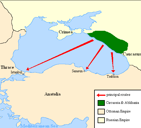
English: Map showing the location of Circassia and the expulsion routes (1859-1864) of the Circassians and other Caucasian peoples to the Ottoman Empire, after the Russian annexation of the North-Caucasus following the Crimean War of 1853-1856.
I used the information of the following two maps: http://www.circassianworld.com/CIRCASSIA1840.jpg And the books: The Northwest Caucasus: past, present, future, Walter Richmond The forgotten minorities of Eastern Europe, Arno TannerРусский: Карта с указанием местонахождения Черкесии и высылки маршрутов (1859-1864) от черкесов и других кавказских народов в состав Османской империи, после русской аннексии Северо-Кавказского следующие Крымской войны 1853-1856 гг. |
| Date | |
| Source | Own work |
| Author | DragonTiger23 |
Licensing
[edit]
| I, the copyright holder of this work, release this work into the public domain. This applies worldwide. In some countries this may not be legally possible; if so: I grant anyone the right to use this work for any purpose, without any conditions, unless such conditions are required by law. |
File history
Click on a date/time to view the file as it appeared at that time.
| Date/Time | Thumbnail | Dimensions | User | Comment | |
|---|---|---|---|---|---|
| current | 20:06, 5 July 2013 | | 491 × 445 (15 KB) | Irānshahr (talk | contribs) | |
| 02:01, 4 July 2013 |  | 491 × 445 (15 KB) | Irānshahr (talk | contribs) | Olahus is correct. | |
| 09:23, 3 July 2013 |  | 491 × 445 (15 KB) | DragonTiger23 (talk | contribs) | Reverted to version as of 18:05, 11 February 2011 | |
| 13:23, 9 December 2011 |  | 491 × 445 (15 KB) | Olahus (talk | contribs) | The Circassian inhabited region was actually much bigger. | |
| 18:05, 11 February 2011 |  | 491 × 445 (15 KB) | DragonTiger23 (talk | contribs) | {{Information |Description ={{en|1=Map showing the location of Circassia and the expulsion routes (1859-1864) of the Circassians and other Caucasian peoples to the Ottoman Empire, after the Russian annexation of the North-Caucasus following the Crimean |
You cannot overwrite this file.
File usage on Commons
There are no pages that use this file.
File usage on other wikis
The following other wikis use this file:
- Usage on bg.wikipedia.org
- Usage on ca.wikipedia.org
- Usage on de.wikipedia.org
- Usage on it.wikipedia.org
- Usage on ja.wikipedia.org
- Usage on lmo.wikipedia.org
- Usage on nl.wikipedia.org
- Usage on pl.wikipedia.org
- Usage on ru.wikipedia.org
- Usage on ru.wikinews.org
- Usage on sh.wikipedia.org
- Usage on tr.wikipedia.org