File:Explore the Namib Desert of Southern Africa (NESDIS 2020-04-24).jpg

Original file (1,920 × 1,080 pixels, file size: 1.04 MB, MIME type: image/jpeg)
Captions
Captions
Summary
[edit].jpg&action=edit§ion=1)
| Description |
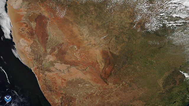
English: Seen through the VIIRS sensor of NOAA-20 on April 17, 2020, one of the least inhabited places in the world is mostly located within the boundaries of the southern African country of Namibia—the 31,274 mi² Namib Desert. The Namib, which in the local Khoekhoegowab language means “vast place,” is considered the only true desert in southern Africa. This is due to its minuscule annual precipitation levels of less than eight inches a year and it having no surface water. Life is concentrated on the coastal areas and is supported by the moisture that rolls into the area from the Atlantic Ocean in the form of fog, which comes on average only 40 days every year. Temperatures can range as high as 122 degrees Fahrenheit, to below freezing, due to the geographical and environmental factors that could otherwise help moderate its climate.
In 2013, the desert was designated a UNESCO world heritage site because of its unique climate and estimated age of 55 million years, making it the oldest desert in the world. According to UNESCO, the Namib is the only coastal desert that generates fog that later shapes and influences its vast dune fields. Also, the fog is a key part of a three-part conveyer system which assists the transition of silt and other particles from the African interior, along with river erosion, ocean currents, and wind. Elsewhere in the world, dunes are created through particles from eroded bedrock. Within its confines, there is the Namib-Naukluft National Park, which contains a rich ecosystem of smaller reptiles, mid-size mammalian predators, and unusual insects not found anywhere else in the world. The country that it mostly resides in, Namibia, is also considered one of the most isolated places in the world, which assists conservation efforts for the area. This image was captured by the NOAA-20 satellite's VIIRS instrument , which scans the entire Earth twice per day at a 750-meter resolution. Multiple visible and infrared channels allow it to detect atmospheric aerosols, such as dust, smoke, and haze associated with industrial pollution and fires. The polar-orbiting satellite circles the globe 14 timesdaily and captures a complete daytime view of our planet once every 24 hours. |
| Date | 24 April 2020 (upload date) |
| Source | Explore the Namib Desert of Southern Africa |
| Author | NOAA |
Licensing
[edit].jpg&action=edit§ion=2)
This image is in the public domain because it contains materials that originally came from the U.S. National Oceanic and Atmospheric Administration, taken or made as part of an employee's official duties.
|
File history
Click on a date/time to view the file as it appeared at that time.
| Date/Time | Thumbnail | Dimensions | User | Comment | |
|---|---|---|---|---|---|
| current | 17:58, 3 June 2024 | | 1,920 × 1,080 (1.04 MB) | OptimusPrimeBot (talk | contribs) | #Spacemedia - Upload of https://nesdis-prod.s3.amazonaws.com/migrated/iod42420.jpg via Commons:Spacemedia |
You cannot overwrite this file.
File usage on Commons
There are no pages that use this file.
.jpg&oldid=881172859)