File:Evansville, Indiana (map) - compiled from official records and surveys by J.D. and M. S. Saunders. - DPLA - ba0fdb4bbd2062f5b676e34be742cbcc (page 6).jpg
Jump to navigation
Jump to search

Size of this preview: 800 × 522 pixels. Other resolutions: 320 × 209 pixels | 640 × 418 pixels | 1,024 × 669 pixels | 1,280 × 836 pixels | 2,560 × 1,672 pixels | 8,252 × 5,389 pixels.
Original file (8,252 × 5,389 pixels, file size: 5.85 MB, MIME type: image/jpeg)
Captions
Captions
Add a one-line explanation of what this file represents
Summary
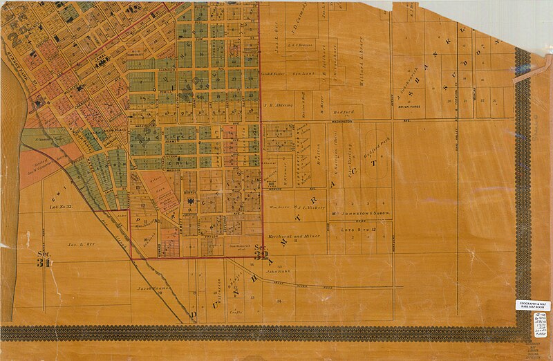
[edit]| Evansville, Indiana [map] / compiled from official records and surveys by J.D. and M. S. Saunders.
( |
|||||||||||||||||
|---|---|---|---|---|---|---|---|---|---|---|---|---|---|---|---|---|---|
| Creator | Saunders, J. D; Saunders, M. S | ||||||||||||||||
| Title |
Evansville, Indiana [map] / compiled from official records and surveys by J.D. and M. S. Saunders. |
||||||||||||||||
| Description |
Cadastral map showing some landowners; Originally printed in 2 sheets; Stamped on: Copyright 1890 by J.D. & M.S. Saunders; Includes index to buildings.; 1 map : hand col., dissected in 6 pieces and mounted on linen and shellacked ; 129 x 132 cm., pieces 48 x 71 or smaller.; Scale not given. |
||||||||||||||||
| Date | 1890 | ||||||||||||||||
| Collection |
|
||||||||||||||||
| Source/Photographer |
|
||||||||||||||||
| Permission (Reusing this file) |
Copyright determination made by Indiana University Libraries ( Q58241552) using RightsStatements.org
|
||||||||||||||||


_-_compiled_from_official_records_and_surveys_by_J.D._and_M._S._Saunders._-_DPLA_-_ba0fdb4bbd2062f5b676e34be742cbcc_(page_6).jpg&action=edit§ion=1)
File history
Click on a date/time to view the file as it appeared at that time.
| Date/Time | Thumbnail | Dimensions | User | Comment | |
|---|---|---|---|---|---|
| current | 00:09, 9 April 2023 | | 8,252 × 5,389 (5.85 MB) | DPLA bot (talk | contribs) | Uploading DPLA ID dpla:ba0fdb4bbd2062f5b676e34be742cbcc |
You cannot overwrite this file.
File usage on Commons
The following page uses this file:
_-_compiled_from_official_records_and_surveys_by_J.D._and_M._S._Saunders._-_DPLA_-_ba0fdb4bbd2062f5b676e34be742cbcc_(page_6).jpg)
_-_compiled_from_official_records_and_surveys_by_J.D._and_M._S._Saunders._-_DPLA_-_ba0fdb4bbd2062f5b676e34be742cbcc_(page_6).jpg&oldid=783502611)