File:European countries by median wealth per adult, 2018.jpg
Jump to navigation
Jump to search

Size of this preview: 800 × 547 pixels. Other resolutions: 320 × 219 pixels | 640 × 438 pixels | 1,024 × 701 pixels | 1,280 × 876 pixels | 2,560 × 1,752 pixels | 4,091 × 2,799 pixels.
Original file (4,091 × 2,799 pixels, file size: 2.06 MB, MIME type: image/jpeg)
Captions
Captions
Add a one-line explanation of what this file represents
Summary
[edit]
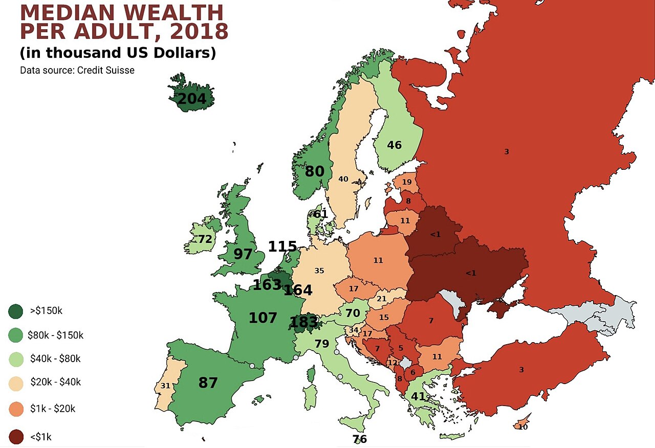
| Description | A map showing European countries by median wealth per adult in thousands of US dollars, based on Credit Suisse's Global Wealth Report 2018. See Table 3.1 (page 114) of the databook for mean and median wealth by country. |
| Date | - date of first upload of this file. |
| Source | Own work |
| Author | Radom1967 |
Licensing
[edit]
| This map was created for free at MapChart.net. All maps created there are licensed under the Creative Commons Attribution-ShareAlike 4.0 International License. See the "Licensing" link on the home page, or the MapChart.net feedback page for the image license info, and this MapChart.net Commons discussion. Use {{Mapchart.net}} to provide attribution for maps created with that service.
See also: Other maps on Commons created with Mapchart.net: Category:Mapchart.net and this search query; other map and chart resources. |
I, the copyright holder of this work, hereby publish it under the following license:
This file is licensed under the Creative Commons Attribution-Share Alike 4.0 International license.
- You are free:
- to share – to copy, distribute and transmit the work
- to remix – to adapt the work
- Under the following conditions:
- attribution – You must give appropriate credit, provide a link to the license, and indicate if changes were made. You may do so in any reasonable manner, but not in any way that suggests the licensor endorses you or your use.
- share alike – If you remix, transform, or build upon the material, you must distribute your contributions under the same or compatible license as the original.
File history
Click on a date/time to view the file as it appeared at that time.
| Date/Time | Thumbnail | Dimensions | User | Comment | |
|---|---|---|---|---|---|
| current | 18:12, 9 January 2024 | | 4,091 × 2,799 (2.06 MB) | Iktsokh (talk | contribs) | Clearing the map |
| 10:46, 21 February 2023 |  | 4,091 × 2,799 (2.02 MB) | Iktsokh (talk | contribs) | Clearing | |
| 12:39, 4 February 2023 |  | 4,091 × 2,799 (1.95 MB) | Рагин1987 (talk | contribs) | Countries of North Africa outside of Europe, in contrast to the politically, historically, and culturally related states | |
| 15:43, 17 January 2023 |  | 1,618 × 1,342 (274 KB) | Radom1967 (talk | contribs) | Reverted to version as of 11:23, 12 November 2018 (UTC) | |
| 17:57, 14 August 2022 |  | 4,091 × 2,799 (2.35 MB) | Рагин1987 (talk | contribs) | Extended map | |
| 11:23, 12 November 2018 |  | 1,618 × 1,342 (274 KB) | Radom1967 (talk | contribs) | User created page with UploadWizard |
You cannot overwrite this file.
File usage on Commons
The following page uses this file:
File usage on other wikis
The following other wikis use this file:
- Usage on en.wikipedia.org
- Usage on hy.wikipedia.org
- Usage on ja.wikipedia.org
- Usage on uz.wikipedia.org