File:Europe rail electrification de.svg
Jump to navigation
Jump to search

Size of this PNG preview of this SVG file: 680 × 520 pixels. Other resolutions: 314 × 240 pixels | 628 × 480 pixels | 1,004 × 768 pixels | 1,280 × 979 pixels | 2,560 × 1,958 pixels.
Original file (SVG file, nominally 680 × 520 pixels, file size: 557 KB)
Captions
Captions
Add a one-line explanation of what this file represents
| Description |
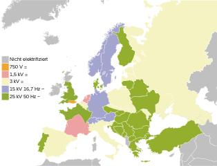
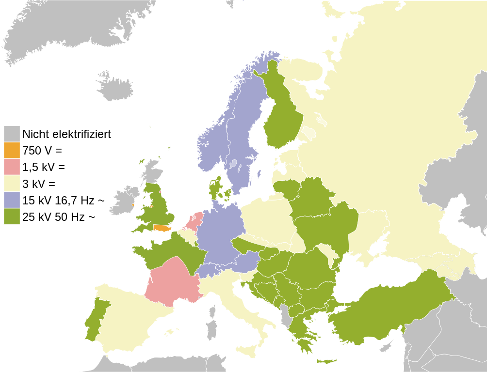
English: Map of the railway electrification systems in Europe
Deutsch: Bahnstromnetze in Europa
Italiano: Mappa del sistema di elettrificazione ferroviaria in Europa |
| Date | (UTC) |
| Source | |
| Author |
|
| This is a retouched picture, which means that it has been digitally altered from its original version. Modifications: Translation. The original can be viewed here: Europe rail electrification en.svg:
|
I, the copyright holder of this work, hereby publish it under the following license:
| I, the copyright holder of this work, release this work into the public domain. This applies worldwide. In some countries this may not be legally possible; if so: I grant anyone the right to use this work for any purpose, without any conditions, unless such conditions are required by law. |
Original upload log
[edit]
This image is a derivative work of the following images:
- File:Europe_rail_electrification_en.svg licensed with PD-self
- 2010-05-24T14:47:33Z N299 680x520 (551774 Bytes) {{Information |Description={{en|Map of the railway electrification systems in Europe}} |Source=*[[:File:Europe_rail_electrification.png|]] *[[:File:Blank_map_europe.svg|]] |Date=2010-05-24 14:42 (UTC) |Author=*[[:File:Europe_
Uploaded with derivativeFX
File history
Click on a date/time to view the file as it appeared at that time.
| Date/Time | Thumbnail | Dimensions | User | Comment | |
|---|---|---|---|---|---|
| current | 05:51, 6 September 2022 | | 680 × 520 (557 KB) | Рагин1987 (talk | contribs) | Added countries |
| 15:44, 23 July 2011 |  | 680 × 520 (539 KB) | Simon04 (talk | contribs) | {{Information |Description={{en|Map of the railway electrification systems in Europe}} {{de|Bahnstromnetze in Europa}} |Source=*File:Europe_rail_electrification_en.svg |Date=2011-07-23 15:43 (UTC) |Author=*[[:File:Europe_rail_electrification_en.svg| |
You cannot overwrite this file.
File usage on Commons
The following 3 pages use this file:
File usage on other wikis
The following other wikis use this file:
- Usage on de.wikipedia.org
- Usage on it.wikipedia.org
- Usage on ja.wikipedia.org
- Usage on lb.wikipedia.org