File:Europe in 814, Charlemagne, Krum, Nicephorus I.png
Jump to navigation
Jump to search
Size of this preview: 800 × 583 pixels. Other resolutions: 320 × 233 pixels | 640 × 467 pixels | 1,024 × 747 pixels | 1,218 × 888 pixels.
Original file (1,218 × 888 pixels, file size: 102 KB, MIME type: image/png)
Captions
Captions
Add a one-line explanation of what this file represents
Summary
[edit]
| Description |
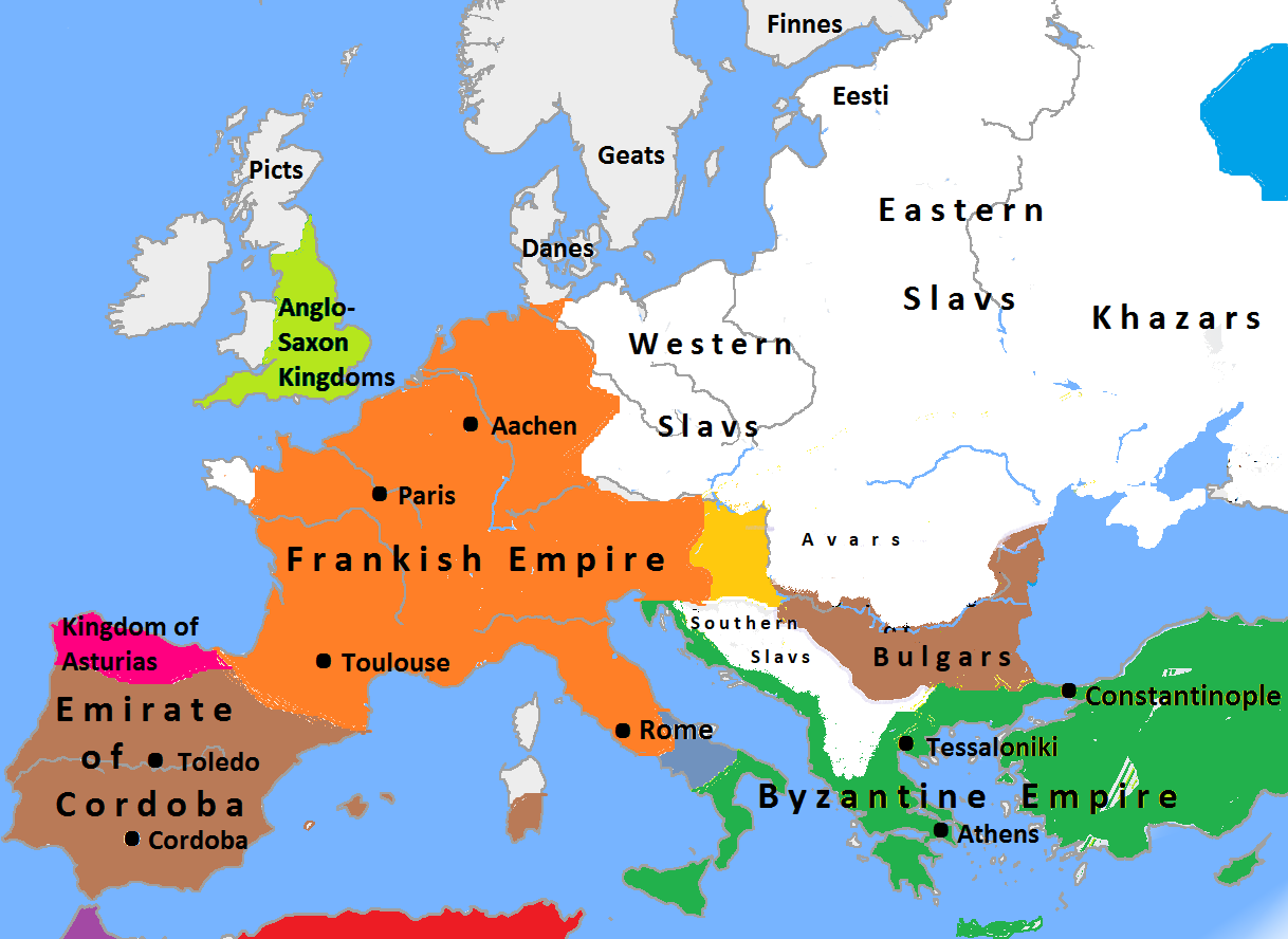
English: Map of Europe in 814 |
| Date | |
| Source |
Europe_plain_rivers.png
|
| Author | Stolichanin |
| Other versions | العربيَّة |
Licensing
[edit]
I, the copyright holder of this work, hereby publish it under the following licenses:

|
Permission is granted to copy, distribute and/or modify this document under the terms of the GNU Free Documentation License, Version 1.2 or any later version published by the Free Software Foundation; with no Invariant Sections, no Front-Cover Texts, and no Back-Cover Texts. A copy of the license is included in the section entitled GNU Free Documentation License. |
This file is licensed under the Creative Commons Attribution-Share Alike 3.0 Unported license.
- You are free:
- to share – to copy, distribute and transmit the work
- to remix – to adapt the work
- Under the following conditions:
- attribution – You must give appropriate credit, provide a link to the license, and indicate if changes were made. You may do so in any reasonable manner, but not in any way that suggests the licensor endorses you or your use.
- share alike – If you remix, transform, or build upon the material, you must distribute your contributions under the same or compatible license as the original.
You may select the license of your choice.
File history
Click on a date/time to view the file as it appeared at that time.
| Date/Time | Thumbnail | Dimensions | User | Comment | |
|---|---|---|---|---|---|
| current | 19:33, 25 April 2024 | | 1,218 × 888 (102 KB) | OrionNimrod (talk | contribs) | Reverted to version as of 05:03, 12 November 2020 (UTC) Vlachs in 800? Any contemporary source which know about them there before 1200s? |
| 04:45, 27 January 2022 |  | 1,218 × 888 (103 KB) | Stolichanin (talk | contribs) | Reverted to version as of 05:15, 13 November 2020 (UTC) | |
| 05:09, 25 January 2022 |  | 1,218 × 888 (122 KB) | Stolichanin (talk | contribs) | Reverted to version as of 18:29, 19 December 2014 (UTC) | |
| 05:15, 13 November 2020 |  | 1,218 × 888 (103 KB) | Stolichanin (talk | contribs) | new sources | |
| 05:03, 12 November 2020 |  | 1,218 × 888 (102 KB) | Stolichanin (talk | contribs) | New sources | |
| 04:15, 4 August 2020 |  | 1,218 × 888 (104 KB) | Stolichanin (talk | contribs) | Borders by new sources | |
| 18:29, 19 December 2014 |  | 1,218 × 888 (122 KB) | Stolichanin (talk | contribs) | Sicily | |
| 17:58, 19 December 2014 |  | 1,218 × 888 (122 KB) | Stolichanin (talk | contribs) | {{subst:Upload marker added by en.wp UW}} {{Information |Description = {{en|Map of Europe in 814}} |Source = {{own}} |Date = 2014-12-19 |Author = Stolichanin }} |
You cannot overwrite this file.
File usage on Commons
The following 3 pages use this file:
File usage on other wikis
The following other wikis use this file:
- Usage on ar.wikipedia.org
- Usage on el.wikipedia.org
- Usage on fa.wikipedia.org
- Usage on ht.wikipedia.org
- Usage on hy.wikipedia.org
- Usage on id.wikipedia.org
- Usage on no.wikipedia.org
- Usage on pt.wikipedia.org
- Usage on sl.wikipedia.org
- Usage on sr.wikipedia.org
- Usage on zh.wikipedia.org