File:Europe 1740 lt.png
Jump to navigation
Jump to search
Size of this preview: 800 × 571 pixels. Other resolutions: 320 × 228 pixels | 640 × 456 pixels | 1,024 × 730 pixels | 1,280 × 913 pixels | 2,560 × 1,826 pixels | 5,163 × 3,682 pixels.
Original file (5,163 × 3,682 pixels, file size: 1.7 MB, MIME type: image/png)
Captions
Captions
Add a one-line explanation of what this file represents
Summary
[edit]
| Description |
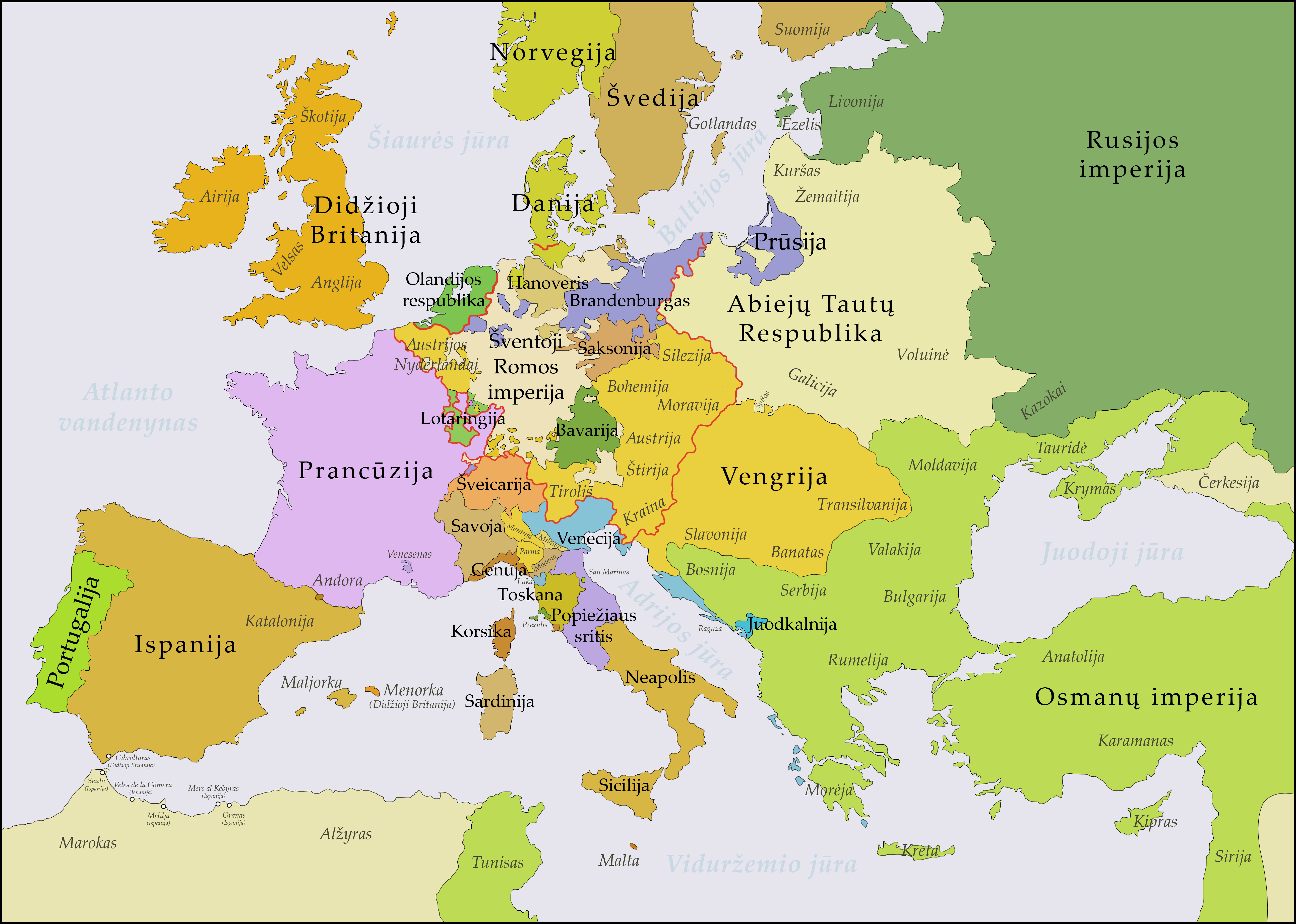
English: This map shows Europe in the years between the 1739 Treaty of Belgrade (the end of the Austro–Turkish War (1737–39)) and the beginning of the War of the Austrian Succession in 1740. The red line marks the borders of the Holy Roman Empire. The work was created with Inkscape and is mainly based on a map in: Putzger - Historischer Weltatlas, Berlin 1990, 78 pp.
Lietuvių: Žemėlapyje pavaizduota Europa po 1739 m. Belgrado taikos (pabaigusios Austrijos–Turkijos karą (1737–1739)) ir 1740 m. prasidėjus Austrijos įpėdinystės karui. Raudona linija pažymėtos Šventosios Romos imperijos sienos. Vaizdas sukurtas naudojant „Inkscape“, daugiausia remiantis žemėlapiu iš Putzger - Historischer Weltatlas, Berlin 1990, 78 pp. |
| Date | |
| Source | Own work, based on File:Europe 1740 en.png |
| Author | Adamvs |
Licensing
[edit]
I, the copyright holder of this work, hereby publish it under the following license:
This file is licensed under the Creative Commons Attribution-Share Alike 4.0 International license.
- You are free:
- to share – to copy, distribute and transmit the work
- to remix – to adapt the work
- Under the following conditions:
- attribution – You must give appropriate credit, provide a link to the license, and indicate if changes were made. You may do so in any reasonable manner, but not in any way that suggests the licensor endorses you or your use.
- share alike – If you remix, transform, or build upon the material, you must distribute your contributions under the same or compatible license as the original.
File history
Click on a date/time to view the file as it appeared at that time.
| Date/Time | Thumbnail | Dimensions | User | Comment | |
|---|---|---|---|---|---|
| current | 17:16, 30 October 2023 | | 5,163 × 3,682 (1.7 MB) | Adamvs (talk | contribs) | State of Presidi and Ösel label |
| 21:52, 23 January 2023 |  | 3,872 × 2,761 (1.35 MB) | Adamvs (talk | contribs) | Improved translation of the State of the Presidi | |
| 15:57, 23 January 2023 |  | 3,872 × 2,761 (1.35 MB) | Adamvs (talk | contribs) | =={{int:filedesc}}== {{Information |Description={{de|1=Diese Karte zeigt Europa in den Jahren nach dem Frieden von Aachen 1748 und in der Zeit des Siebenjährigen Krieges (1756-1763). Bis 1766 kam es zu keinen größeren geographischen Veränderungen in Europa. Die Arbeit wurde mit Inkscape erstellt und beruht hauptsächlich auf einer Karte in: ''Putzger - Historischer Weltatlas'', Berlin 1990, S.78f.}} {{en|1=This ma... |
You cannot overwrite this file.
File usage on Commons
The following 2 pages use this file:
File usage on other wikis
The following other wikis use this file:
- Usage on lt.wikipedia.org