File:Europa geografisch karte de 1.png
Jump to navigation
Jump to search

Size of this preview: 800 × 523 pixels. Other resolutions: 320 × 209 pixels | 640 × 418 pixels | 1,024 × 669 pixels | 1,280 × 836 pixels | 1,596 × 1,043 pixels.
Original file (1,596 × 1,043 pixels, file size: 227 KB, MIME type: image/png)
Captions
Captions
Add a one-line explanation of what this file represents
Summary
[edit]
| Description |
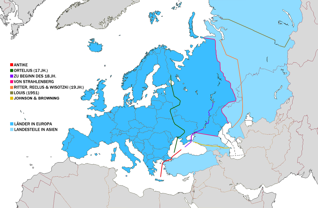
Deutsch: Europas geografische Grenzen nach unterschiedlichen Definitionen:
|
| Date | 23 October 2006 (original upload date) |
| Source | Own work (Original text: Selbstgemacht aus File:Europa geografisch map de.png und File:Europe political map.png) |
| Author | BillFromTheHill at German Wikipedia, transfered from de.wikipedia by W like wiki. |
| Other versions |
 |
Licensing
[edit]
This file is licensed under the Creative Commons Attribution-Share Alike 3.0 Unported license.
- You are free:
- to share – to copy, distribute and transmit the work
- to remix – to adapt the work
- Under the following conditions:
- attribution – You must give appropriate credit, provide a link to the license, and indicate if changes were made. You may do so in any reasonable manner, but not in any way that suggests the licensor endorses you or your use.
- share alike – If you remix, transform, or build upon the material, you must distribute your contributions under the same or compatible license as the original.

|
This map of europe image could be re-created using vector graphics as an SVG file. This has several advantages; see Commons:Media for cleanup for more information. If an SVG form of this image is available, please upload it and afterwards replace this template with
{{vector version available|new image name}}.
It is recommended to name the SVG file “Europa geografisch karte de 1.svg”—then the template Vector version available (or Vva) does not need the new image name parameter. |
Original upload log
[edit]
Transferred from de.wikipedia to Commons by W like wiki using CommonsHelper.
The original description page was here. All following user names refer to de.wikipedia.
- 2006-10-23 21:35 BillFromTheHill 1596×1043× (163066 bytes) Selbstgemacht aus Vorlage: Europa_geografisch_map.png
File history
Click on a date/time to view the file as it appeared at that time.
| Date/Time | Thumbnail | Dimensions | User | Comment | |
|---|---|---|---|---|---|
| current | 16:18, 6 August 2022 | | 1,596 × 1,043 (227 KB) | Рагин1987 (talk | contribs) | Korrektur zusätzlicher Linien auf dem Territorium der Ukraine |
| 23:38, 5 August 2022 |  | 1,596 × 1,043 (227 KB) | Рагин1987 (talk | contribs) | Feste Schattierung | |
| 23:34, 5 August 2022 |  | 1,596 × 1,043 (227 KB) | Рагин1987 (talk | contribs) | Aus welchen Gründen gibt es keine Option für eine Grenze entlang des Großen Kaukasus? Diese Unterscheidung wird seit 1896 in den Karten von Johnson und Browning bis heute verwendet. | |
| 15:20, 12 November 2013 |  | 1,596 × 1,043 (159 KB) | File Upload Bot (Magnus Manske) (talk | contribs) | Transfered from de.wikipedia by User:W like wiki using CommonsHelper |
You cannot overwrite this file.
File usage on Commons
The following page uses this file:
File usage on other wikis
The following other wikis use this file:
- Usage on de.wikipedia.org
- Usage on la.wikipedia.org
- Usage on lv.wikipedia.org
- Usage on rm.wikipedia.org