File:Ethnic map of Montenegro by municipality according to 2011 census and 2023 borders (in Albanian).svg
Jump to navigation
Jump to search

Size of this PNG preview of this SVG file: 495 × 599 pixels. Other resolutions: 198 × 240 pixels | 397 × 480 pixels | 635 × 768 pixels | 846 × 1,024 pixels | 1,693 × 2,048 pixels | 996 × 1,205 pixels.
Original file (SVG file, nominally 996 × 1,205 pixels, file size: 262 KB)
Captions
Captions
Ethnic map of Montenegro by municipality
Summary
[edit].svg&action=edit§ion=1)
| Description |
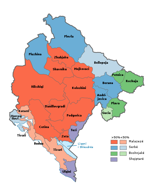
English: Ethnic map of Montenegro by municipality according to 2011 census and 2023 borders (in Albanian) Shqip: Hartë etnike e Malit të Zi sipas komunave, bazuar në censusin e vitit 2011 dhe kufijve ndërkomunal të vitit 2023 |
| Date | |
| Source |
Based on data from Census 2011 This W3C-unspecified vector image was created with Inkscape . This vector image includes elements that have been taken or adapted from this file: |
| Author | AT44 |
Licensing
[edit].svg&action=edit§ion=2)
This file is licensed under the Creative Commons Attribution-Share Alike 4.0 International license.
- You are free:
- to share – to copy, distribute and transmit the work
- to remix – to adapt the work
- Under the following conditions:
- attribution – You must give appropriate credit, provide a link to the license, and indicate if changes were made. You may do so in any reasonable manner, but not in any way that suggests the licensor endorses you or your use.
- share alike – If you remix, transform, or build upon the material, you must distribute your contributions under the same or compatible license as the original.
File history
Click on a date/time to view the file as it appeared at that time.
| Date/Time | Thumbnail | Dimensions | User | Comment | |
|---|---|---|---|---|---|
| current | 08:33, 2 March 2023 | | 996 × 1,205 (262 KB) | AT44 (talk | contribs) | Uploaded a work by AT44 from Based on data from [https://www.monstat.org/cg/page.php?id=536&pageid=322 Census 2011] {{Inkscape}}{{AttribSVG|Montenegro, administrative divisions - sq - colored 2022.svg |AT44}} with UploadWizard |
You cannot overwrite this file.
File usage on Commons
The following page uses this file:
File usage on other wikis
The following other wikis use this file:
- Usage on sq.wikipedia.org
.svg&oldid=737773797)