File:Ethnic map USSR 1930.jpg
Jump to navigation
Jump to search
Size of this preview: 800 × 589 pixels. Other resolutions: 320 × 236 pixels | 640 × 472 pixels | 1,024 × 755 pixels | 1,280 × 943 pixels | 2,560 × 1,886 pixels | 3,287 × 2,422 pixels.
Original file (3,287 × 2,422 pixels, file size: 1.28 MB, MIME type: image/jpeg)
Captions
Captions
Add a one-line explanation of what this file represents
Summary
[edit]| Description |
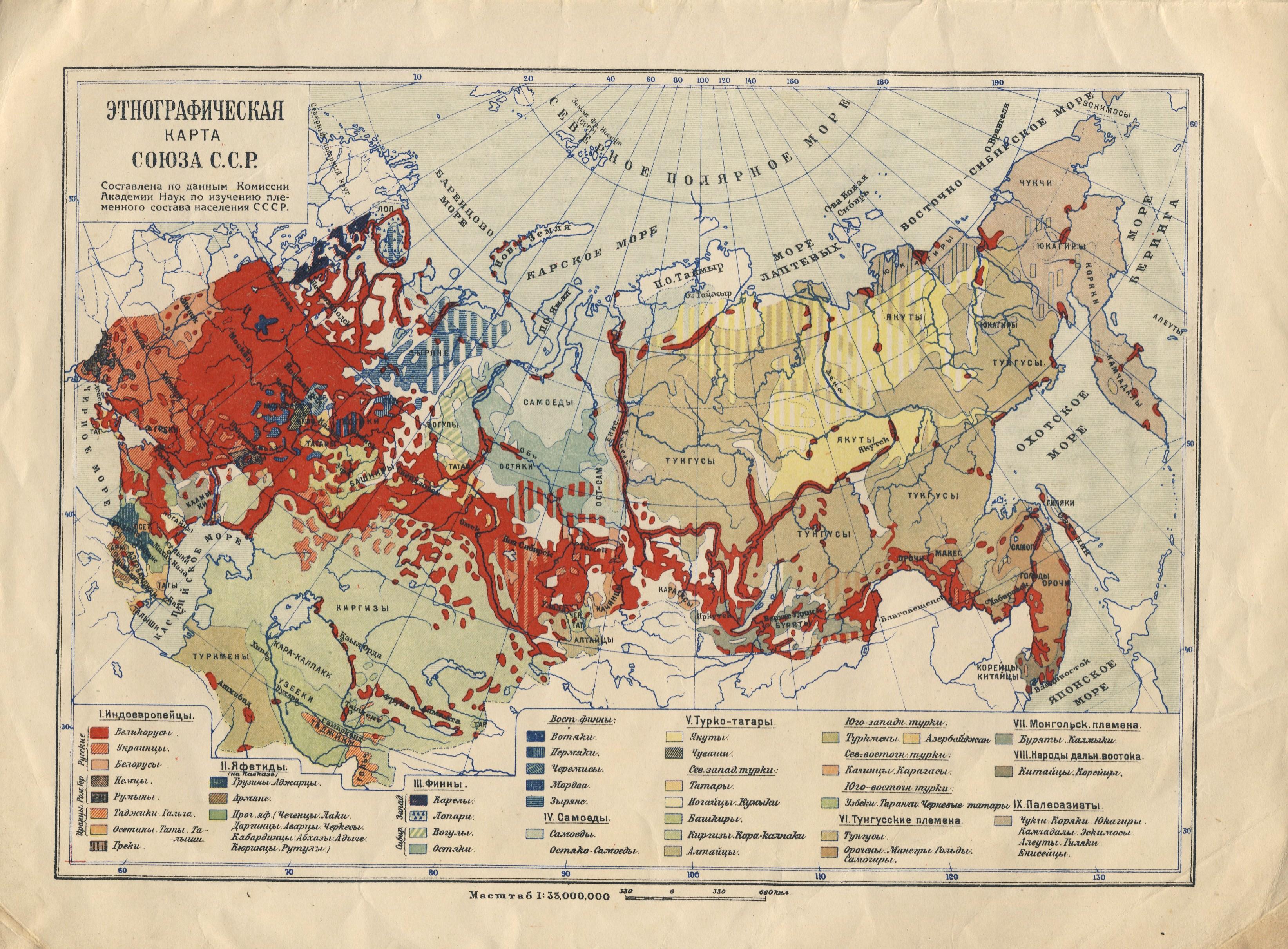
Русский: Этнографическая карта СССР. Составлена по данным Комиссии Академии Наук по изучению племенного состава населения СССР
Українська: Етнографічна карта СРСР. Складена за даними Комісії Академії Наук по вивченню племінного складу населення СРСР
English: Ethnographic map of the USSR. Compiled according to the Commission of the Academy of Sciences for the study of the tribal composition of the population of the USSR |
|||||||||||||||||||||||
| Date | ||||||||||||||||||||||||
| Source | Географический Атлас в 16 таблиц под ред. Ю. Шокальского, 1930. | |||||||||||||||||||||||
| Author |
|
|||||||||||||||||||||||

Licensing
[edit]
|
This is a faithful photographic reproduction of a two-dimensional, public domain work of art. The work of art itself is in the public domain for the following reason:
The official position taken by the Wikimedia Foundation is that "faithful reproductions of two-dimensional public domain works of art are public domain".
This photographic reproduction is therefore also considered to be in the public domain in the United States. In other jurisdictions, re-use of this content may be restricted; see Reuse of PD-Art photographs for details. | ||||
File history
Click on a date/time to view the file as it appeared at that time.
| Date/Time | Thumbnail | Dimensions | User | Comment | |
|---|---|---|---|---|---|
| current | 22:57, 29 April 2020 | | 3,287 × 2,422 (1.28 MB) | Lanamy (talk | contribs) | Uploaded a work by Ю. Шокальский from Географический Атлас в 16 таблиц под ред. Ю. Шокальского, 1930. with UploadWizard |
You cannot overwrite this file.
File usage on Commons
There are no pages that use this file.
File usage on other wikis
The following other wikis use this file:
- Usage on en.wikipedia.org