File:Espansione indoeuropea Kossinna.png
Jump to navigation
Jump to search

Size of this preview: 800 × 502 pixels. Other resolutions: 320 × 201 pixels | 640 × 401 pixels | 1,024 × 642 pixels | 1,280 × 802 pixels | 1,777 × 1,114 pixels.
Original file (1,777 × 1,114 pixels, file size: 743 KB, MIME type: image/png)
Captions
Captions
Add a one-line explanation of what this file represents
Summary
[edit]
| Description |
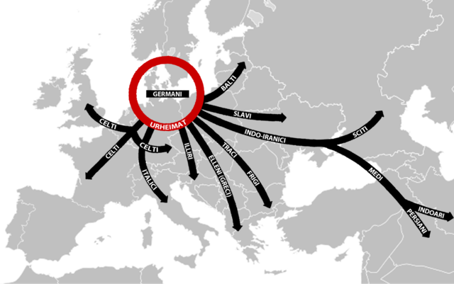
Italiano: L'Urheimat indoeuropeo (cerchio rosso) e l'espansione delle popolazioni indoeuropee secondo Kossinna. |
| Date | (UTC) |
| Source |
This file was derived from: Blank map europe123.png: |
| Author |
|
| This is a retouched picture, which means that it has been digitally altered from its original version. Modifications: Modificata e inserite frecce per indicare l'espansione indoeuropea Kossinna. The original can be viewed here: Blank map europe123.png:
|
Licensing
[edit]
I, the copyright holder of this work, hereby publish it under the following licenses:
This file is licensed under the Creative Commons Attribution-Share Alike 3.0 Unported license.
- You are free:
- to share – to copy, distribute and transmit the work
- to remix – to adapt the work
- Under the following conditions:
- attribution – You must give appropriate credit, provide a link to the license, and indicate if changes were made. You may do so in any reasonable manner, but not in any way that suggests the licensor endorses you or your use.
- share alike – If you remix, transform, or build upon the material, you must distribute your contributions under the same or compatible license as the original.

|
Permission is granted to copy, distribute and/or modify this document under the terms of the GNU Free Documentation License, Version 1.2 or any later version published by the Free Software Foundation; with no Invariant Sections, no Front-Cover Texts, and no Back-Cover Texts. A copy of the license is included in the section entitled GNU Free Documentation License. |
You may select the license of your choice.
Original upload log
[edit]
This image is a derivative work of the following images:
- File:Blank_map_europe123.png licensed with Cc-by-sa-3.0, GFDL
- 2010-04-07T06:17:47Z Jennifer1982 680x520 (76639 Bytes) {{Information |Description={{en|1=map europe}} |Source={{own}} |Author=[[User:Jennifer1982|Jennifer1982]] |Date=2010-04-07 |Permission= |other_versions= }} [[Category:Europe]]
Uploaded with derivativeFX
File history
Click on a date/time to view the file as it appeared at that time.
| Date/Time | Thumbnail | Dimensions | User | Comment | |
|---|---|---|---|---|---|
| current | 10:36, 10 June 2012 | | 1,777 × 1,114 (743 KB) | Yiyi (talk | contribs) | Metto sfondo trasparente. |
| 10:30, 10 June 2012 |  | 1,777 × 1,114 (695 KB) | Yiyi (talk | contribs) | == {{int:filedesc}} == {{Information |Description={{en|1=map europe}} |Source={{Derived from|Blank_map_europe123.png|display=50}} |Date=2012-06-10 10:29 (UTC) |Author=*File:Blank_map_europe123.png: Jennifer1982 *derivative w... |
You cannot overwrite this file.
File usage on Commons
There are no pages that use this file.
File usage on other wikis
The following other wikis use this file:
- Usage on bs.wikipedia.org
- Usage on gl.wikipedia.org
- Usage on it.wikipedia.org
- Usage on sh.wikipedia.org