File:Escutcheon on the stable block, Ratcliffe Hall (geograph 4458959).jpg
Jump to navigation
Jump to search
Size of this preview: 441 × 600 pixels. Other resolutions: 176 × 240 pixels | 353 × 480 pixels | 941 × 1,280 pixels.
Original file (941 × 1,280 pixels, file size: 301 KB, MIME type: image/jpeg)
Captions
Captions
Add a one-line explanation of what this file represents
Summary
[edit].jpg&action=edit§ion=1)
| Description |
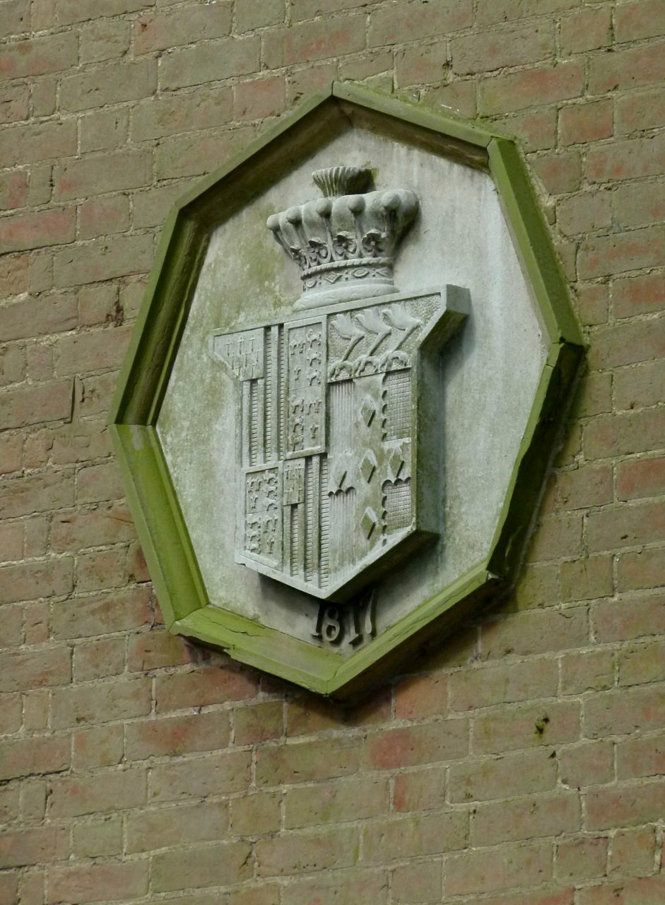
English: Escutcheon on the stable block, Ratcliffe Hall. Arms of Robert Shirley, 7th Earl Ferrers (1756-1827), who married secondly (on 28 September 1799) Elizabeth Mundy (d.1827), a daughter of Wrightson Mundy. Shirley (Paly of six or and azure, a canton ermine) quartering royal arms of Thomas of Woodstock, 1st Duke of Gloucester (5th surviving son of King Edward III): Royal arms of King Edward III differenced by a bordure argent; (a Bourchier quartering; Sir Henry Shirley, 2nd Baronet (1588-1633) (ancestor of 1st Earl Ferrers) married Lady Dorothy Devereux, daughter of Robert Devereux, 2nd Earl of Essex. On the death of her brother Robert Devereux, 3rd Earl of Essex, she became the youngest co-heiress to the baronies of Ferrers of Chartley and the barony of Bourchier, which had fallen into abeyance on the death of the 3rd Earl). Impaling Mundy: Per pale gules and sable, on a cross engrailed argent five lozenges purpure on a chief or three eagle's legs erased a-la-quise azure (Burke, Sir Bernard, The General Armory, London, 1884, p.716 "Mundy of Markeaton, Derbyshire") |
| Date | |
| Source | From geograph.org.uk |
| Author | Alan Murray-Rust |
| Permission (Reusing this file) |
Creative Commons Attribution Share-alike license 2.0 |
| Attribution (required by the license) | Alan Murray-Rust / Escutcheon on the stable block, Ratcliffe Hall / |
| Camera location | | View this and other nearby images on: OpenStreetMap |
|---|
.jpg¶ms=052.723242_N_-001.070285_E_globe:Earth_type:camera_heading:337.00_source:geograph&language=en)
| Object location | | View this and other nearby images on: OpenStreetMap |
|---|
.jpg¶ms=052.723380_N_-001.070400_E_globe:Earth_class:object_type:object_source:geograph-osgb36(SK62881437)_region:GB-GBN_heading:337.00&language=en)
Licensing
[edit].jpg&action=edit§ion=2)

|
This image was taken from the Geograph project collection. See this photograph's page on the Geograph website for the photographer's contact details. The copyright on this image is owned by Alan Murray-Rust and is licensed for reuse under the Creative Commons Attribution-ShareAlike 2.0 license.
|
This file is licensed under the Creative Commons Attribution-Share Alike 2.0 Generic license.
Attribution: Alan Murray-Rust
- You are free:
- to share – to copy, distribute and transmit the work
- to remix – to adapt the work
- Under the following conditions:
- attribution – You must give appropriate credit, provide a link to the license, and indicate if changes were made. You may do so in any reasonable manner, but not in any way that suggests the licensor endorses you or your use.
- share alike – If you remix, transform, or build upon the material, you must distribute your contributions under the same or compatible license as the original.
File history
Click on a date/time to view the file as it appeared at that time.
| Date/Time | Thumbnail | Dimensions | User | Comment | |
|---|---|---|---|---|---|
| current | 15:17, 30 September 2017 | | 941 × 1,280 (301 KB) | Kaliforniyka (talk | contribs) | Transferred from geograph.co.uk using [https://tools.wmflabs.org/geograph2commons/ geograph2commons] |
You cannot overwrite this file.
File usage on Commons
The following page uses this file:
File usage on other wikis
The following other wikis use this file:
- Usage on www.wikidata.org
.jpg&oldid=802211214)