File:Escadre allemande d'Extrême-Orient 1914 1915-de.svg
Jump to navigation
Jump to search

Size of this PNG preview of this SVG file: 800 × 413 pixels. Other resolutions: 320 × 165 pixels | 640 × 330 pixels | 1,024 × 529 pixels | 1,280 × 661 pixels | 2,560 × 1,321 pixels | 3,100 × 1,600 pixels.
Original file (SVG file, nominally 3,100 × 1,600 pixels, file size: 1.12 MB)
Captions
Captions
Add a one-line explanation of what this file represents
Summary
[edit]
| Description |
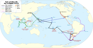
Deutsch: Routen, Stationen und Seegefechten des Ostasiengeschwaders von Juni 1914 bis März 1915. English: Routes, stations and battles of the German East Asia Squadron from June 1914 to March 1915. Français : Routes, étapes et batailles de l'escadre d'Extrême-Orient entre juin 1914 et mars 1915. |
| Date | |
| Source |
This file was derived from:
|
| Author |
|
| Other versions | |
| SVG development | This world map is translated using SVG switch elements: all translations are stored in the same file. |
_(180E).svg)
Licensing
[edit]
I, the copyright holder of this work, hereby publish it under the following licenses:
| Copyleft: This work of art is free; you can redistribute it and/or modify it according to terms of the Free Art License. You will find a specimen of this license on the Copyleft Attitude site as well as on other sites. |
This file is licensed under the Creative Commons Attribution-Share Alike 4.0 International, 3.0 Unported, 2.5 Generic, 2.0 Generic and 1.0 Generic license.
- You are free:
- to share – to copy, distribute and transmit the work
- to remix – to adapt the work
- Under the following conditions:
- attribution – You must give appropriate credit, provide a link to the license, and indicate if changes were made. You may do so in any reasonable manner, but not in any way that suggests the licensor endorses you or your use.
- share alike – If you remix, transform, or build upon the material, you must distribute your contributions under the same or compatible license as the original.
You may select the license of your choice.
Original upload log
[edit]
This image is a derivative work of the following images:
- Ostasiengeschwader 1914-15.png licensed with Cc-by-sa-3.0, Cc-by-sa-3.0-de, GFDL
- 2011-09-12T01:44:02Z File Upload Bot (Magnus Manske) 2000x1488 (406202 Bytes) {{BotMoveToCommons|de.wikipedia|year={{subst:CURRENTYEAR}}|month={{subst:CURRENTMONTHNAME}}|day={{subst:CURRENTDAY}}}} {{Information |Description={{de|Routen und Stationen des Ostasiengeschwaders von August 1914 bis März 19
- Cruise of the Emden 1914 Map.png licensed with PD-US
- 2008-11-07T05:20:00Z Rcbutcher 767x548 (94370 Bytes) ''{{Information |Description=Map showing the cruise of German raider, light cruiser SMS Emden in the Indian Ocean September - November 1914.|Source="A History of Sea Power". From Official British Naval History, Vol. I.<br>Downloaded from Project Gu
- Blank map of the world (Robinson projection) (180E).svg licensed with PD-self
- 2011-05-16T02:05:36Z Milenioscuro 3100x1600 (2154098 Bytes) {{Information |Description=A blank map of the world centered at the 180E longitude line. |Source=*[[:File:BlankMap-World-180E.svg|]] |Date=2011-05-16 02:04 (UTC) |Author=*[[:File:BlankMap-World-180E.svg|]]: [[:User:Lokal_Prof
File history
Click on a date/time to view the file as it appeared at that time.
| Date/Time | Thumbnail | Dimensions | User | Comment | |
|---|---|---|---|---|---|
| current | 19:02, 1 January 2021 | | 3,100 × 1,600 (1.12 MB) | Artoria2e5 (talk | contribs) | Add language detection hack |
| 18:52, 1 January 2021 |  | 3,100 × 1,600 (1.12 MB) | Artoria2e5 (talk | contribs) | File uploaded using svgtranslate tool (https://svgtranslate.toolforge.org/). Added translation for en. | |
| 11:36, 6 April 2020 |  | 3,100 × 1,600 (1.11 MB) | Andreas P 15 (talk | contribs) | File uploaded using svgtranslate tool (https://tools.wmflabs.org/svgtranslate/). Added translation for hu. | |
| 17:40, 11 March 2014 |  | 3,100 × 1,600 (1.08 MB) | Kopiersperre (talk | contribs) | == {{int:filedesc}} == {{Information |Description= {{Multilingual description |de= Routen, Stationen und Seegefechten des Ostasiengeschwaders von Juni 1914 bis März 1915. |en= Routes, stations and battles of the [[:en:Germa... |
You cannot overwrite this file.
File usage on Commons
The following 7 pages use this file:
- User:Chumwa/OgreBot/Transport Maps/2020 April 1-10
- User:Chumwa/OgreBot/Transport Maps/2021 January 1-10
- User:Magog the Ogre/Maps of conflicts/2020 April
- User:Magog the Ogre/Maps of conflicts/2021 January
- User:Matthias Süßen/East Frisia/2020 April
- User:Matthias Süßen/East Frisia/2021 January
- User:OgreBot/Watercraft/2014 March 9-12
File usage on other wikis
The following other wikis use this file:
- Usage on ca.wikipedia.org
- Usage on de.wikipedia.org
- Usage on el.wikipedia.org
- Usage on en.wikipedia.org
- Usage on es.wikipedia.org
- Usage on hu.wikipedia.org
- Usage on it.wikipedia.org
- Usage on nl.wikipedia.org
- Usage on pl.wikipedia.org
- Usage on vi.wikipedia.org