File:Engelhartstetten - Schloss Niederweiden (4).JPG
Jump to navigation
Jump to search

Size of this preview: 800 × 477 pixels. Other resolutions: 320 × 191 pixels | 640 × 381 pixels | 1,024 × 610 pixels | 1,280 × 763 pixels | 2,560 × 1,526 pixels | 4,369 × 2,604 pixels.
Original file (4,369 × 2,604 pixels, file size: 9.17 MB, MIME type: image/jpeg)
Captions
Captions
Add a one-line explanation of what this file represents
Summary
[edit]| Description |
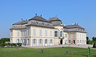
Deutsch: Südwestansicht des Schlosses Niederweiden in der niederösterreichischen Marktgemeinde Engelhartstetten.
Der Vorgängerbau wurde bei der 1. Türkenbelagerung zerstört. 1685 übernahm Ernst Rüdiger von Starhemberg die Herrschaft und ließ unmittelbar neben der öde Veste durch Johann Bernhard Fischer von Erlach ein Lustschloss errichten. 1725 wurde das Schloss von Prinz Eugen von Savoyen erworben und später dann von Maria Theresia. Diese ließ das Schloss um 1765 durch den Hofarchitekten Nikolaus Pacassi umbauen. Dabei erhielt das Schloss im Wesentlichen sein heutiges Erscheinungsbild. Nach schweren Kriegsschäden 1945 und einem Brand 1956 begann man mit der Restaurierung und Rekonstruktion, die 1986 abgeschlossen wurde. |
| Date | |
| Source | Own work |
| Author | C.Stadler/Bwag |
| Permission (Reusing this file) |
Deutsch: Hallo, du darfst meine Fotos kostenlos nutzen, aber nenne mich bitte als Fotograf, beispielsweise „Foto: C.Stadler/Bwag“ oder © C.Stadler/Bwag; CC-BY-SA-4.0. Auf mehr Angaben bestehe ich nicht - im Gegensatz zu manch anderen, die die Vorgaben der unten angeführten Lizenzierung auf Punkt und Beistrich einfordern. English: Feel free to use my photos, but please mention me as the author like © C.Stadler/Bwag or © C.Stadler/Bwag; CC-BY-SA-4.0 (that's good enough) and if you want send me a message: bwag@gmx.net. |
| Other versions |
|
.JPG)
.JPG&action=edit§ion=1)
| Object location | | View this and other nearby images on: OpenStreetMap |
|---|
.JPG¶ms=048.197890_N_0016.900980_E_globe:Earth_class:object_type:object__&language=en)
| Camera location | | View this and other nearby images on: OpenStreetMap |
|---|
.JPG¶ms=048.197430_N_0016.901580_E_globe:Earth_type:camera_heading:310.00&language=en)
Licensing
[edit].JPG&action=edit§ion=2)
I, the copyright holder of this work, hereby publish it under the following license:
This file is licensed under the Creative Commons Attribution-Share Alike 4.0 International license.
- You are free:
- to share – to copy, distribute and transmit the work
- to remix – to adapt the work
- Under the following conditions:
- attribution – You must give appropriate credit, provide a link to the license, and indicate if changes were made. You may do so in any reasonable manner, but not in any way that suggests the licensor endorses you or your use.
- share alike – If you remix, transform, or build upon the material, you must distribute your contributions under the same or compatible license as the original.
File history
Click on a date/time to view the file as it appeared at that time.
| Date/Time | Thumbnail | Dimensions | User | Comment | |
|---|---|---|---|---|---|
| current | 17:21, 15 May 2018 | | 4,369 × 2,604 (9.17 MB) | Bwag (talk | contribs) | {{Information |Description= {{de|1= Südwestansicht des Schlosses Niederweiden in der niederösterreichischen Marktgemeinde Engelhartstetten.<br/>Der Vorgängerbau wurde bei der 1. Türkenbelagerung zerstört. 1685 übernahm Ernst Rüdiger von Starhemberg die Herrschaft und ließ unmittelbar neben der ''öde Veste'' durch Johann Bernhard Fischer von Erlach ein Lustsch... |
You cannot overwrite this file.
File usage on Commons
The following 2 pages use this file:
File usage on other wikis
The following other wikis use this file:
- Usage on ceb.wikipedia.org
- Usage on cs.wikipedia.org
- Usage on de.wikipedia.org
- Usage on de.wikivoyage.org
- Usage on en.wikipedia.org
- Usage on www.wikidata.org
.JPG&oldid=706357356)