File:Empires chinois et japonais LOC 2006629415.jpg
Jump to navigation
Jump to search

Size of this preview: 796 × 600 pixels. Other resolutions: 319 × 240 pixels | 637 × 480 pixels | 1,019 × 768 pixels | 1,280 × 964 pixels | 2,560 × 1,929 pixels | 6,400 × 4,822 pixels.
Original file (6,400 × 4,822 pixels, file size: 5.51 MB, MIME type: image/jpeg)
Captions
Captions
Add a one-line explanation of what this file represents
Summary
[edit]| Description |
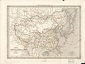
English: Relief shown by hachures. Shows roads, overprinted in red. Prime meridian: Paris. From Dufour and Duvotenay's Atlas de geographie. Paris : Dufour et Duvotenay, 1840. In pencil in upper left corner: 34. LC copy stamped on: 626888. Available also through the Library of Congress Web site as a raster image. |
||
| Title | Empires chinois et japonais | ||
| Shelf ID | G7820 1840 .D8 | ||
| Date | |||
| Source | https://www.loc.gov/item/2006629415/ | ||
| Author | Dufour, A.-H. (Auguste-Henri) | ||
| Permission (Reusing this file) |
|
||
| Other versions |
|
||
| Location | Japan · China. · China · Japan. | ||
| Part of | American Memory · General Maps · Catalog · Geography And Map Division | ||
| Subject | Roads · Maps · China · Japan |


Licensing
[edit]
|
This is a faithful photographic reproduction of a two-dimensional, public domain work of art. The work of art itself is in the public domain for the following reason:
The official position taken by the Wikimedia Foundation is that "faithful reproductions of two-dimensional public domain works of art are public domain".
This photographic reproduction is therefore also considered to be in the public domain in the United States. In other jurisdictions, re-use of this content may be restricted; see Reuse of PD-Art photographs for details. | ||||
File history
Click on a date/time to view the file as it appeared at that time.
| Date/Time | Thumbnail | Dimensions | User | Comment | |
|---|---|---|---|---|---|
| current | 17:07, 5 August 2018 | | 6,400 × 4,822 (5.51 MB) | Fæ (talk | contribs) | LOC Maps https://www.loc.gov/item/2006629415/ #23398 |
You cannot overwrite this file.
File usage on Commons
The following 6 pages use this file:
Categories:
- Maps in the Library of Congress
- 1840s maps of Japan
- 1840s maps of Korea
- 1840 maps of Taiwan
- Mongolia in the 1840s
- Tibet in the 1840s
- 1840s maps of China
- 19th-century maps of Mongolia
- 19th-century maps of Tibet
- 1840 maps of Asia
- French-language maps of China
- 1840 engravings
- Engravings from France
- Old maps of the Qing Dynasty
- Maps by Auguste Henri Dufour