File:Emmanuel church - geograph.org.uk - 883851.jpg
Jump to navigation
Jump to search
No higher resolution available.
Emmanuel_church_-_geograph.org.uk_-_883851.jpg (640 × 480 pixels, file size: 183 KB, MIME type: image/jpeg)
Captions
Captions
Add a one-line explanation of what this file represents
Summary
[edit]
| Description |
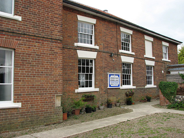
English: Emmanuel church. Emmanuel Church, accessible via a narrow lane > 883845 off White Hart Street, serves the Baptist community; the building dates from 1789 and was originally a Methodist church. Sadly, this church is kept locked. The Emmanuel Church Hall > 622429 is located in Cawston Road, further to the southwest. |
| Date | |
| Source | From geograph.org.uk |
| Author | Evelyn Simak |
| Attribution (required by the license) | Evelyn Simak / Emmanuel church / |
| Camera location | | View this and other nearby images on: OpenStreetMap |
|---|
_heading:247.00&language=en)
| Object location | | View this and other nearby images on: OpenStreetMap |
|---|
_heading:247.00&language=en)
Licensing
[edit]

|
This image was taken from the Geograph project collection. See this photograph's page on the Geograph website for the photographer's contact details. The copyright on this image is owned by Evelyn Simak and is licensed for reuse under the Creative Commons Attribution-ShareAlike 2.0 license.
|
This file is licensed under the Creative Commons Attribution-Share Alike 2.0 Generic license.
Attribution: Evelyn Simak
- You are free:
- to share – to copy, distribute and transmit the work
- to remix – to adapt the work
- Under the following conditions:
- attribution – You must give appropriate credit, provide a link to the license, and indicate if changes were made. You may do so in any reasonable manner, but not in any way that suggests the licensor endorses you or your use.
- share alike – If you remix, transform, or build upon the material, you must distribute your contributions under the same or compatible license as the original.
File history
Click on a date/time to view the file as it appeared at that time.
| Date/Time | Thumbnail | Dimensions | User | Comment | |
|---|---|---|---|---|---|
| current | 12:16, 21 February 2011 | | 640 × 480 (183 KB) | GeographBot (talk | contribs) | == {{int:filedesc}} == {{Information |description={{en|1=Emmanuel church Emmanuel Church, accessible via a narrow lane > http://www.geograph.org.uk/photo/883845 off White Hart Street, serves the Baptist community; the building dates from 1789 and was orig |
You cannot overwrite this file.
File usage on Commons
There are no pages that use this file.