File:Emergency Arts, Fremont East District, Las Vegas, Nevada.jpg

Original file (4,000 × 3,000 pixels, file size: 2.54 MB, MIME type: image/jpeg)
Captions
Captions
Summary
[edit]
| Description |
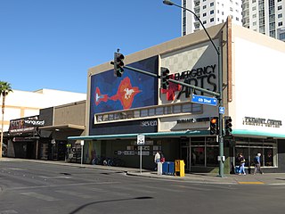
English: Downtown Las Vegas is the central business district of Las Vegas, Nevada. It is the original townsite and gambling district of Las Vegas, prior to the Strip, and the area still incorporates downtown gaming. As the urban core of the Las Vegas Valley, it features a variety of hotel and business highrises, cultural centers, historical buildings and government institutions, as well as residential and retail developments. Downtown is located in the center of the Las Vegas Valley and just north of the Las Vegas Strip, centered on Fremont Street, the Fremont Street Experience and Fremont East. The city defines the area as bounded by I-15 on the west, Washington Avenue on the north, Maryland Parkway on the east and Sahara Avenue on the south.
Property and business owners have been working to redevelop Fremont Street just east of the Fremont Street Experience. In 2002, the city of Las Vegas Redevelopment Agency joined with Fremont East property and business owners to create a business improvement district, as well as pay for a $5.5 million streetscape improvement. This area is called the Fremont East Entertainment District. It features an eclectic mix of bars, clubs and restaurants. Centered on Las Vegas Boulevard on Fremont Street, this three-block renovation includes pedestrian-friendly street redesign, landscaping and retro-looking neon signage. en.wikipedia.org/wiki/Downtown_Las_Vegas en.wikipedia.org/wiki/Wikipedia:Text_of_Creative_Commons_... |
| Date | |
| Source | https://www.flickr.com/photos/kenlund/15278843520/ |
| Author | Ken Lund |
| Camera location | | View this and other nearby images on: OpenStreetMap |
|---|
Licensing
[edit]
- You are free:
- to share – to copy, distribute and transmit the work
- to remix – to adapt the work
- Under the following conditions:
- attribution – You must give appropriate credit, provide a link to the license, and indicate if changes were made. You may do so in any reasonable manner, but not in any way that suggests the licensor endorses you or your use.
- share alike – If you remix, transform, or build upon the material, you must distribute your contributions under the same or compatible license as the original.
| This image was originally posted to Flickr by Ken Lund at https://flickr.com/photos/75683070@N00/15278843520 (archive). It was reviewed on 1 March 2019 by FlickreviewR 2 and was confirmed to be licensed under the terms of the cc-by-sa-2.0. |
File history
Click on a date/time to view the file as it appeared at that time.
| Date/Time | Thumbnail | Dimensions | User | Comment | |
|---|---|---|---|---|---|
| current | 06:22, 1 March 2019 | | 4,000 × 3,000 (2.54 MB) | Missvain (talk | contribs) | User created page with UploadWizard |
You cannot overwrite this file.
File usage on Commons
The following page uses this file:
File usage on other wikis
The following other wikis use this file:
- Usage on www.wikidata.org