File:Emeljanovka1917.jpg
Jump to navigation
Jump to search

Size of this preview: 800 × 565 pixels. Other resolutions: 320 × 226 pixels | 640 × 452 pixels | 1,024 × 723 pixels | 1,280 × 904 pixels | 1,700 × 1,200 pixels.
Original file (1,700 × 1,200 pixels, file size: 789 KB, MIME type: image/jpeg)
Captions
Captions
Add a one-line explanation of what this file represents
Summary
[edit]
| Description |
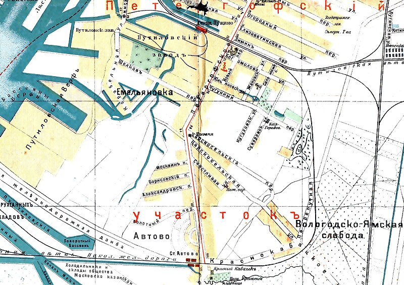
Русский: Деревня Емельяновка на карте 1917 года |
| Date | |
| Source | http://www.etomesto.ru/view.php?map=peterburg_1917&key=1&x=30.249643&y=59.879236 |
| Author | План из путеводителя Суворина 1917 года: Весь Петроград |
Licensing
[edit]
|
This work is in the public domain in its country of origin and other countries and areas where the copyright term is the author's life plus 70 years or fewer. This work is in the public domain in the United States because it was published (or registered with the U.S. Copyright Office) before January 1, 1929. | |
| This file has been identified as being free of known restrictions under copyright law, including all related and neighboring rights. | |
File history
Click on a date/time to view the file as it appeared at that time.
| Date/Time | Thumbnail | Dimensions | User | Comment | |
|---|---|---|---|---|---|
| current | 20:39, 16 July 2023 | | 1,700 × 1,200 (789 KB) | Valeriy10f (talk | contribs) | =={{int:filedesc}}== {{Information |description={{ru|1=Деревня Емельяновка на карте 1917 года}} |date=1917 |source=http://www.etomesto.ru/map-peterburg_1917/ |author=План из путеводителя Суворина 1917 года: Весь Петроград |permission= |other versions= }} =={{int:license-header}}== {{PD-old-70-1923}} Category:Old maps of Saint Petersburg |
You cannot overwrite this file.
File usage on Commons
There are no pages that use this file.
File usage on other wikis
The following other wikis use this file:
- Usage on ru.wikipedia.org